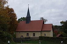
Hüddingen
|
Hüddingen
City of Bad Wildungen
Coordinates: 51 ° 5 ′ 44 ″ N , 9 ° 1 ′ 14 ″ E
|
|
|---|---|
| Height : | 370 (364-400) m |
| Area : | 6.18 km² |
| Residents : | 86 (December 31, 2018) |
| Population density : | 14 inhabitants / km² |
| Incorporation : | December 31, 1971 |
| Postal code : | 34537 |
| Area code : | 05621 |
Hüddingen is the smallest district in terms of population in the town of Bad Wildungen in the Waldeck-Frankenberg district in northern Hesse .
geography
The cluster village of Hüddingen is located west of Bad Wildungen in the Kellerwald and is surrounded by forest. On the eastern edge of the town, three small headwaters of the total of about 6 km long unite three of Bach , who in Gellershausen coming from the south in the Eder influx Wesebach flows .
history
The "Heddingen" settlement was first mentioned in a document in 1209 when the Fritzlar Petri-Stift recorded income there.
A parish has been associated with the Hüddinger Church since 1410. Until the Reformation it belonged to the Archdeaconate Fritzlar. Today the Bad Wildunger districts Albertshausen and Reinhardshausen belong to the evangelical parish of Hüddingen.
On December 31, 1971, Hüddingen was incorporated into the city of Bad Wildungen as part of the regional reform in Hesse .
Attractions
Some old farmhouses and the former parsonage with bar inscriptions in the half-timbered houses are well worth seeing .
On the eastern edge of the village, directly on the K 39, there is a small half-timbered house on the former "Zimmerplatz" , in which a permanent exhibition with historical tools provides information about carpentry work and the history of Hüddinger. The small museum was built as part of the preparation for the 3rd Hessian State Garden Show in Bad Wildungen in 2006 with the support of the vocational school of the German carpentry trade Kassel.
The Romanesque church , which was probably originally from the 12th century, was completely renovated in 1782, but still contains its Romanesque rectangular choir , making it the oldest preserved church in Bad Wildungen and one of the oldest churches in the Eder parish. Inside there is a sacrament niche with Gothic minuscule as well as wall paintings in the chancel that were exposed and restored in 1853 (a stylized scroll with the year 1513 in Gothic minuscule is shown) and a bar inscription from 1616. The bells date from the 15th and 16th centuries. The first organ was installed in the choir room in 1849 and came from the organ builder Vogt; it was replaced in 1955 by a Möller organ on the front wall of the nave . Another renovation took place from 2001 to 2007.
traffic
Hüddingen is located on Kreisstraße 39 north of federal highway 253 . Supra-local thoroughfares do not touch the place. The 6th stage ends in the village and the 7th stage of the Kellerwaldsteig begins , and the Barbarossaweg also leads through the village.
Individual evidence
- ↑ City of Bad Wildungen in figures , accessed on February 8, 2019
- ^ Federal Statistical Office (ed.): Historical municipality directory for the Federal Republic of Germany. Name, border and key number changes in municipalities, counties and administrative districts from May 27, 1970 to December 31, 1982 . W. Kohlhammer GmbH, Stuttgart and Mainz 1983, ISBN 3-17-003263-1 , p. 408 .
- ↑ Photo of the museum building
- ↑ The Protestant Church in Hüddingen
literature
- Literature about Hüddingen in the Hessian Bibliography
- Search for Hüddingen in the archive portal-D of the German Digital Library
Web links
- District Hüddingen. In: Internet presence. City of Bad Wildungen
- Hüddingen, Waldeck-Frankenberg district. Historical local dictionary for Hessen. In: Landesgeschichtliches Informationssystem Hessen (LAGIS).


