Chabomai
| Chabomai | ||
|---|---|---|
| The archipelago seen from space | ||
| Waters | Pacific Ocean | |
| archipelago | Kuril Islands | |
| Geographical location | 43 ° 30 ' N , 146 ° 8' E | |
|
|
||
| Number of islands | 10 larger and more rocks | |
| Main island | Seljony | |
| Total land area | 99.9 km² | |
| Residents | uninhabited | |
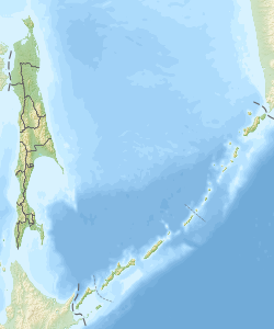
| Overview map | ||
Chabomai ( Russian Хабомай ; Japanese 歯 舞 群島 Habomai-guntō or 歯 舞 諸島 Habomai-shotō ) is the southernmost island group within the Kuril Islands . The islands - part of Sakhalin Oblast - are under Russian control like Iturup , Kunashir and Shikotan , but are claimed by Japan .
Islands
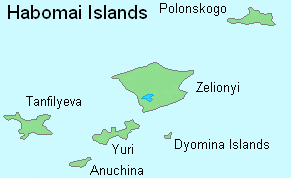
The Chabomai group consists of the ten larger islands or groups of islands, as well as several surrounding smaller rock islands. On the island of Juri (Yuri), the archipelago reaches its maximum elevation with a height of 45 m . The largest island is Seljony (Shibotsu), which with 51 km² takes up more than half of the land area of the entire archipelago.
| Russian | Japanese | Coordinates | |||
|---|---|---|---|---|---|
| Polonskogo Street | Пролив Полонского | Shikotan Street | 色 丹 水道 | ||
| Polonskogo | Остров Полонского | Taraku-tō | 多 楽 島 | 43 ° 38 ' N , 146 ° 19' E | |
| Polonskogo | м. Полонского | Kabu-tō | カ ブ 島 | 43 ° 37 ' N , 146 ° 22' E | |
| Oskolki Islands | Острова Осколки | ||||
|
|
Peshchernaya | Скала Пещерная | Kanakuso-tō | カ ナ ク ソ 島 | 43 ° 36 ' N , 146 ° 26' E |
| Shishki Islands | Острова Шишки | Kabuto-tō | カ ブ ト 島 | 43 ° 34 ' N , 146 ° 26' E | |
| Lisji Islands | Острова Лисьи | Todo-jima | 海馬 島 | 43 ° 34 ' N , 146 ° 24' E | |
| Wojeikowa Street | Пролив Воейкова | Taraku Street | 多 楽 水道 | ||
| Seljony | Остров Зелёный | Shibotsu-tō | 志 発 島 | 43 ° 30 ' N , 146 ° 8' E | |
| Djomina Islands | Острова Дёмина | Harukarimoshiri-tō | ハ ル カ リ モ シ リ 島 | 43 ° 25 ' N , 146 ° 10' E | |
| Yuri | Остров Юрий | Yuri-tō | 勇 留 島 | 43 ° 25 ' N , 146 ° 4' E | |
| Yuri Street | Пролив Юрий | Yuri Street | 勇 留 水道 | ||
| Anuchina | Остров Анучина | Akiyuri-tō | 秋 勇 留 島 | 43 ° 22 ' N , 146 ° 0' E | |
| Tanfileva | Остров Танфильева | Suishō-jima | 水晶 島 | 43 ° 26 ' N , 145 ° 55' E | |
| Storoschewoi | Остров Сторожевой | Moemoshiri-tō | 萌 茂 尻 島 | 43 ° 23 ' N , 145 ° 54' E | |
| Rifowy | Остров Рифовый | Odoke-tō | オ ド ケ 島 | 43 ° 23 ' N , 145 ° 53' E | |
| Signalny | Остров Сигнальный | Kaigara-jima | 貝殻 島 | 43 ° 24 ' N , 145 ° 51' E | |
| Sowetski Street | Советский пролив | Goyōmai Street | 珸 瑤 瑁 水道 | ||
|
|
|||||
history
Chabomai was occupied by Soviet troops during the final days of the Pacific War . Since then, Japan has been trying to return the islands as a result of the Kuril conflict . With the exception of a Russian border guard , Chabomai is uninhabited today.


