
Herbolzheim (Neudenau)
|
Herbolzheim
City of Neudenau
|
|
|---|---|
 |
|
| Height : | 158 m above sea level NN |
| Area : | 7.07 km² |
| Residents : | 1608 (2009) |
| Population density : | 227 inhabitants / km² |
| Incorporation : | 1st January 1975 |
| Postal code : | 74861 |
| Area code : | 06264 |

Herbolzheim (in the local dialect Herwelze ) is a village in Baden-Württemberg that has been part of the city of Neudenau in the Heilbronn district since 1975 .
history
The oldest traces of settlement in Herbolzheim were found on the right bank of the Jagst in Gewann Kirchengärten and along the cemetery path. Stone Age and Bronze Age finds show that place as an ancient settlement. On the left of the Jagst, in the Gewann Eurich, Roman remains of the wall were discovered, while the early medieval settlement at the time of the Franks is proven again on the right of the Jagst in the area of the Gassenweg . The place was first mentioned in the Lorsch Codex in 863 as "Heribotesheim" on the occasion of an extensive donation of goods from a Germo to the Lorsch Monastery . The name ending in -heim points to a Franconian foundation of today's place, the name describes the place as the property of a tribal prince Heribot.
Presumably at the time of the Hungarian invasions in the early 10th century, the village on the right side of the Jagst was destroyed and abandoned. Only the cemetery and the old church of St. Wendelin remained on the right bank. Instead, people then settled on the left side of the Jagst, where Herbolzheim Castle was built on a ridge at the latest by the High Middle Ages, where the Lords of Herbolzheim, first mentioned in 1268, had their seat. Little is known about the Lords of Herbolzheim. The family died out in the late 15th century, and the castle was also destroyed by then. Below the castle, today's settlement of the town center developed as a castle hamlet.
Around 1330 the village with the castle was sold to the Bishopric of Worms , from 1361 it was owned by the Mainz electors . Within Kurmainz, Herbolzheim was part of the Amorbach Oberamt and, within it, the Neudenau Office. In Herbolzheim there was a winery until 1688 , after which Neudenau was part of the administration.
With the other Electoral Mainz properties Neudenau and Stein am Kocher , the place came to Count Wenzel von Leiningen-Heidesheim as a result of the Napoleonic Wars in 1802 . In 1806 the Leiningen possessions were incorporated into the Grand Duchy of Baden , but the Leiningen-Neudenau line retained numerous goods and rights in Herbolzheim. The lordly rights were lost to the people of Leiningen in the course of the Baden Revolution in 1848, and the house still owned the building until 1918.

Within Baden, Herbolzheim first belonged to the Neudenau office and later to the Mosbach district . The high taxes and burdens of war led to great poverty in Herbolzheim in the 19th century. Only the industrialization in Heilbronn and Neckarsulm and the connection to the railway line from Heilbronn to Osterburken in 1869 created better economic conditions. The embankment also made the place flood-safe and thus an end to the regular flooding caused by Jagst floods. The upswing in the late 19th century also led to the (re-) settlement of the right Jagstufers. In 1939 there were 715 inhabitants, at the end of 1945 there were 788.
In the course of the Baden-Württemberg district reform in 1973 and the dissolution of the Mosbach district, Herbolzheim became part of the Heilbronn district . On January 1, 1975 it was incorporated into Neudenau.
Herbolzheim has been dominated by agriculture until recently. In 2006, a standard procedure to improve production and working conditions in agriculture through a new network of roads and waterways and the reorganization and amalgamation of the fragmented property is in progress. The village is mainly a residential area for commuters from the surrounding cities and communities.
coat of arms
|
|
Blazon : "In a split shield, split at the bottom, a striding red lion above in gold, below in front a silver wheel in red, behind in gold a red sloping bar." |
| Justification of the coat of arms: The Mainz wheel stands for Kurmainz , the red sloping bar is Baden's coat of arms . |
traffic
Street
The L1096 from Bad Friedrichshall to Züttlingen leads through Herbolzheim. The next motorway connections are in Heilbronn - Neckarsulm to the federal motorway A6 and in Möckmühl -Züttlingen to the A81 .
railroad
Herbolzheim is on the Frankenbahn from Stuttgart to Würzburg . Regional trains stop every hour to Osterburken and Heilbronn , some of which are linked to Würzburg or Stuttgart and Ulm .
Attractions


- The ruins of Heriboldesburg lie on a mountain spur above the village . From the castle, built in the 12th century, only the restored round keep and some remains of the wall are preserved.
- At the site of the outer bailey , an Electoral Mainz administration building, which later became the rectory , was built in the 16th century . It bears the coat of arms of the Lords of Adelsheim and is dated 1564. The neighboring sheep house was built in 1594 and destroyed in the Second World War. Old components were incorporated into the new building that replaced it. The former stately wine press of the town, whose portal was lost in 1865 when the school was built, also belongs to the Electoral Mainz construction period of the late 16th century . From the tithe barn from 1577, which was torn down when the railway was expanded in 1932 , the portal stone has been preserved in another building in the village.
- The oldest church in town was on the right bank of the Jagst in the cemetery. The tower of the Church of St. Wendelin was demolished in 1784 because it was dilapidated, the nave, which was renovated in the 14th century, was demolished in 1825. A Gothic niche in the cemetery wall has been preserved from the church, in which a wooden figure known as the man of the dead was once kept.
- The late Baroque old church of St. Kilian from 1770, which was built to replace St. Wendelin in the center of the village on the site of an old chapel, has been used as an event room ( Bernhardusheim ) since the inauguration of the new Catholic church of St. Kilian .
- The Herbolzheim forest chapel, the Käppele , was built around 1750 at the instigation of a now unknown donor. Pastor Röckel, who was born in Herbolzheim, donated the Way of the Cross at Käppele.
- The town hall dates back to the 14th century, but has been rebuilt and renewed many times.
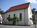
Old Church of St. Kilian

St. Kilian

Käppele


Individual evidence
- ↑ Our 1956, pp. 10/11.
- ↑ Our 1956, p. 11/12.
- ↑ Minst, Karl Josef [trans.]: Lorscher Codex (Volume 5), Certificate 3474, January 26, 863 - Reg. 3451. In: Heidelberg historical stocks - digital. Heidelberg University Library, p. 193 , accessed on January 20, 2018 .
- ↑ Our 1956, p. 19.
- ↑ Our 1956, p. 21.
- ↑ Our 1956, p. 29.
- ↑ Our 1956, p. 39.
- ↑ Our 1956, pp. 40/41.
- ↑ Our 1956, p. 42.
- ↑ Our 1956, p. 43.
- ↑ Our 1956, p. 50.
- ↑ Communications from the Württ. And Bad. State Statistical Office No. 2: Results of the population census on December 31, 1945 in North Baden
- ^ Federal Statistical Office (ed.): Historical municipality directory for the Federal Republic of Germany. Name, border and key number changes in municipalities, counties and administrative districts from May 27, 1970 to December 31, 1982 . W. Kohlhammer, Stuttgart / Mainz 1983, ISBN 3-17-003263-1 , p. 465 .
literature
- Rudolf Unser: History of the village of Herbolzheim an der Jagst, Mosbach 1956.