Hlboké nad Váhom
| Hlboké nad Váhom | ||
|---|---|---|
| coat of arms | map | |

|
|
|
| Basic data | ||
| State : | Slovakia | |
| Kraj : | Žilinský kraj | |
| Okres : | Bytča | |
| Region : | Severné Považie | |
| Area : | 5.359 km² | |
| Residents : | 936 (Dec. 31, 2019) | |
| Population density : | 175 inhabitants per km² | |
| Height : | 347 m nm | |
| Postal code : | 014 01 | |
| Telephone code : | 0 41 | |
| Geographic location : | 49 ° 13 ' N , 18 ° 36' E | |
| License plate : | BY | |
| Kód obce : | 581984 | |
| structure | ||
| Community type : | local community | |
| Administration (as of November 2018) | ||
| Mayor : | Karina Holešová | |
| Address: | Obecný úrad Hlboké nad Váhom č. 218 014 01 Hlboké nad Váhom |
|
| Website: | www.hlbokenadvahom.info | |
| Statistics information on statistics.sk | ||
Hlboké nad Váhom is a municipality in northwestern Slovakia with 936 inhabitants (as of December 31, 2019), which belongs to the Okres Bytča , part of the Žilinský kraj .
geography
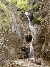
The majority of the municipality is located in the Súľovské vrchy mountains in the valley of the Hlbocký creek in the catchment area of the Waag . Only a small part of the municipality is located in the Bytčianska kotlina basin within the Považské podolie valley . The waterfall Hlbocký vodopád in a small gorge is worth seeing . The center of the village lies at an altitude of 347 m nm and is three and a half kilometers from Bytča and 17 kilometers from Žilina .
Neighboring municipalities are Kotešová in the north, Dolný Hričov in the northeast, Hričovské Podhradie in the east, Paština Závada in the southeast, Súľov-Hradná in the south and Bytča (parts of Hrabové and Hliník nad Váhom ) in the west and northwest.
history
The present municipality was created in 1961 through the merger of the places Dolné Hlboké (Hungarian Alsómélyesd - until 1882 Alsóhloboke ) and Horné Hlboké (Hungarian Felsőmélyesd - until 1882 Felsőhloboke ).
The original place, later Horné Hlboké, was first mentioned in writing in 1347 as Holoboka and was owned by the noble families Hlbokay and Hrabovský . In the 16th century the later Dolné Hlboké was built, which belonged to the dominion of the Hričov castle , later that of Bytča, but part of it was owned by the landed nobility. In 1828 there were 45 houses and 345 inhabitants in both places, whose main source of income was agriculture.
Until 1918, the places in Trenčín County belonged to the Kingdom of Hungary and then came to Czechoslovakia or now Slovakia.
From 1971 to 1998 Hlboké nad Váhom was part of the city of Bytča.
population
According to the 2011 census, there were 937 inhabitants in Hlboké nad Váhom, 906 of them Slovaks and one Czech . 30 residents gave no information on ethnicity .
862 residents committed themselves to the Roman Catholic Church, 6 residents to the Jehovah's Witnesses, 3 residents to the Evangelical Church AB and one resident each to the Evangelical Methodist Church and the Reformed Church. 16 residents had no denomination and 48 residents had no denomination.
Buildings and monuments
- Roman Catholic Church of Seven Sorrows from 1993
Individual evidence
- ↑ Results of the 2011 census (Slovak) ( Memento of the original from March 5, 2016 in the Internet Archive ) Info: The archive link was inserted automatically and has not yet been checked. Please check the original and archive link according to the instructions and then remove this notice.
Web links
- Entry on e-obce.sk (Slovak)

