High Dubrau
| High Dubrau | ||
|---|---|---|
|
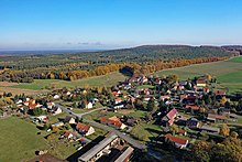
View from Weißig to the Hohen Dubrau |
||
| height | 307 m above sea level HN | |
| location | Saxony , Germany | |
| Mountains | High Dubrau | |
| Coordinates | 51 ° 15 '50 " N , 14 ° 41' 12" E | |
|
|
||
The Hohe Dubrau (also Kollmer Höhen ; Upper Sorbian Wysoka dubrawa ) is a hill country in the district of Görlitz near the municipality of the same name Hohendubrau . The name also designates the main summit, which is 307 m above sea level. NN is the highest point in the Upper Lusatian heath and pond area .
geology
In the core, i.e. in the peaks of Hoher Dubrau and Kollmer Dubrau ( 303 m above sea level ), Monumentberg ( 293 m above sea level ) and Hobians Horken ( 265 m above sea level ), the Precambrian subsoil with old Grauwacken comes to the surface , which (as on the main summit itself) is interspersed with so-called Dubrau quartzite from the Ordovician . The central high elevations at Groß Radisch are lightly covered with loess and are bordered by Elster Ice Age terminal moraines at Dauban , Kollm and Kleinsaubernitz , by ground moraines around Gebelzig and by various Pleistocene sand plates and terraces. In the neighboring hill area of Dubrauke ( 193 m above sea level ) there are gravel banks of an Old Pleistocene tributary of the Elbe. Tertiary clay and lignite layers come to the surface on Kollmer Gemeindeberg ( 222 m above sea level ), near Diehsa and in the east of Dubrauke , while Devonian rocks are added to the south bank of the Quitzdorf reservoir.
Hydrology and flora and fauna

The hill country of the Hohen Dubrau itself is relatively poor in water, some forest streams even seep away after a few 100 meters or disappear in the pipes of the melioration. The Weigersdorfer Fließ rises at the western foot. The ridge has a rich population of deciduous and coniferous trees. As a potential natural vegetation birch and oak-pine forests and alder-ash forests are, in the surrounding meadows. The name (old sorb .: "dubrava" = oak forest) is derived from the oak that was dominant here earlier.
Natural forest-like stands with pine-sessile oak forest in the area of the summit cliffs and with sessile oak-beech forest on the upper and middle slopes of the Hohen and Kollmer Dubrau are together with small areas of enclosed waters, wet meadows, intermediate moors, dry grass and orchards in a 356 hectare area under nature protection. In the area, which is also designated as a Natura 2000 area, round-leaved and medium sundew , knot oak , pondweed and large yellow sedge grow, among other things . In addition to the northern crested newt , breeding birds are of particular interest: the stock dove , gray , black and middle woodpecker , ortolan , miniature flycatcher , red-backed killer , honey buzzard and even a sea eagle have been observed.
tourism
Together with the Quitzdorf dam , the Kollmer Heights form a conservation area that is made accessible to tourists through the design of the Monument Mountain and the layout of various hiking and cycling trails.
literature
- Friedhard Förster, Christian Klouda: The Hohe Dubrau - an outstanding wooded nature reserve in Upper Lusatia. in: Reports of the natural research society of Upper Lusatia. Volume 16, Görlitz 2008, pp. 121-136 ( digitized version )
Web links
- Brief description, aerial photo and further links / downloads at www.umwelt.sachsen.de


