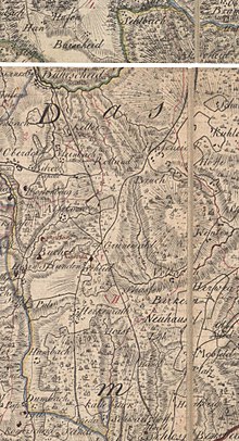
Honesty Herkenrath
The Honschaft Herkenrath was from the Middle Ages to the 19th century, a Honschaft yet parish in office Porz in the Duchy of Berg .
From the Charter of the Duchy of Berg in 1789 by Carl Friedrich von Wiebeking shows that Herkenrath Titularort was the Honschaft and the parish. The honor was assigned to the Herkenrath messenger office and to the Bensberg Higher Court . In the Wiebeking map of 1789 the limits of the Herkenrath Honschaft are shown; it roughly corresponds to today's district of Herkenrath with the exception of hall 011, which was added later.
At that time, the honors included the residential areas Asselborn , Broich , Büchel , Gronewald , Hasselsheide , Herkenrath, Herrenstrunden , Hombach ( Ober- and Unterhombach ), Horst , Neuenhaus , Selbach ( Ober- and Unterselbach ), Scheid , Strassen , Volbach and Wenten .
Under the French administration between 1806 and 1813 the Porz office was dissolved and Herkenrath was politically assigned to Mairie Bensberg in the canton of Bensberg in the Mülheim am Rhein arrondissement . In 1816 the Prussians converted the Mairie to the mayor's office in Bensberg in the Mülheim am Rhein district .
Individual evidence
- ^ A b Wilhelm Fabricius : Explanations of the historical atlas of the Rhine Province, Volume 2: The map of 1789. Bonn, Hermann Behrend, 1898
- ↑ JC Dänzer: Décret impérial sur la circonscription territoriale du grand-duché de Berg… Imperial decree on the division of the Grand Duchy of Berg . 1808.
Coordinates: 50 ° 59 ′ 12 ″ N , 7 ° 11 ′ 34 ″ E
