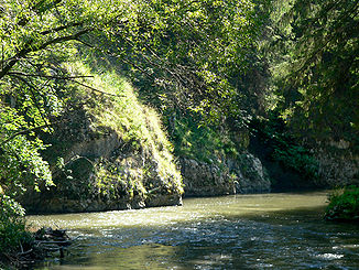
Hornád
|
Hornád Hernád |
||
| Data | ||
| location | Slovakia , Hungary | |
| River system | Danube | |
| Drain over | Sajó → Tisza → Danube → Black Sea | |
| source |
Low Tatras 48 ° 56 ′ 19 ″ N , 20 ° 10 ′ 54 ″ E |
|
| Source height | 1000 m | |
| muzzle |
Sajó bei Muhi Coordinates: 47 ° 59 ′ 25 " N , 20 ° 55 ′ 49" E 47 ° 59 ′ 25 " N , 20 ° 55 ′ 49" E
|
|
| length | 286 km | |
| Catchment area | 5500 km² | |
| Left tributaries | Svinka , Torysa , Olšava | |
| Right tributaries | Hnilec | |
| Reservoirs flowed through | Ružín | |
| Big cities | Košice | |
| Medium-sized cities | Krompachy , Spišská Nová Ves | |
|
The course and the catchment area in Slovakia and Hungary |
||
|
Location of the Hornád in the catchment area of the Tisza |
||
The Hornád ( Hungarian Hernád ; German Hernach , rarely Kundert ) is a 286 km long river in eastern Slovakia and northeastern Hungary . 195 kilometers of the river run on Slovak territory.
It is the fourth largest river in Slovakia and a popular holiday region because of its picturesque upper course in the Slovak Paradise . In the mountains south of its course, various ore deposits have been exploited since the Middle Ages , which earlier helped central Slovakia to a certain prosperity.
River course
The river has its source between the Low Tatras and the foothills of the Slovak Ore Mountains , about 20 km southwest of Poprad .
On its partly winding course, the Hornád touches the culturally and historically well-known landscape of Spiš (see Carpathian Germans and Master Paul von Leutschau ) and flows through the town of Spišská Nová Ves . In contrast to the other large rivers in the country such as the Waag or Hron , the Hornad flows eastwards, so that it forms an east-west axis dividing Slovakia with the Waag. This typical parallel structure of large valleys is typical of the alpine mountains and can be found - practically mirror-inverted - in the large longitudinal valleys of Austria .
The cause of this valley course is largely due to geological fault lines , which, according to the Swiss geophysicist AE Scheidegger, are related to the large-scale rift systems of the various orogenic phases of the earth's history. They make the landscape of the Hornad upper course extremely varied, which is why it is also called the Slovak Paradise .
After a third of the course of the river, the Hornad takes on the Hnilec river and forms an approximately 20 km long reservoir there - between 1200 meter high mountain ranges . After that, the combined river from the Slovak Ore Mountains emerges into a broad plain, which is now occupied by the industrial area of the east Slovak city of Košice . The city with its famous early Gothic St. Elisabeth Cathedral is located high above the river on a valley shoulder , and a little further south is the town of Krásna nad Hornádom, which was founded around 1200 .
At Košice the valley turns south and near the Hungarian border reaches a funnel-shaped extension of the Great Hungarian Plain , which it traverses for another 100 km on Hungarian territory. To the east of the university town of Miskolc , the river, now named Hernád , joins the Sajó , which is about the same size , to pour its water-rich flood into the Tisza 10 km further . Of the huge catchment area of this largest tributary of the Danube (160,000 km², almost twice Hungary), Hornad and Sajó account for almost 10 percent.
In Central Europe there are only a few rivers that come close to the Hornád in terms of diversity of landscape and geology crossed . Nevertheless, his region is still largely untapped for tourism - in contrast to the valleys and cities of its western "big sister", the Waag .
Kecerovce nuclear power plant
For the nuclear power plant planned in Kecerovce in the 1980s , it was planned to build several barrages on the Hornád in order to create a new connection to the Torysa . This should make it possible to cover the water requirements for four 1000 MW reactors. The connection should be created by barrages at Ružín and Kysak , as well as a barrage at Drienov on the Torysa.
swell
- Istituto Geografico de Agostini, Large World Atlas , Munich / Novara 1985
- Brockhaus , Allbuch in 5 volumes and an atlas , volumes 2, 5 and 6, Wiesbaden 1958–1960
- Hydrology of the Danube (4 languages) , 270 p., Publ.Prihoda, Bratislava 1988.
See also
Web links
- Map sketch from the reservoir near Gelnica to the Hungarian border
- Info page of the Košický samosprávny kraj, Košice 2006 (PDF file; 10.5 MB)
Individual evidence
- ↑ a b Article Hornád in the Great Soviet Encyclopedia (BSE) , 3rd edition 1969–1978 (Russian)
- ↑ http://cuni.georeferencer.com/map/DguyWlmAW1U9AQhiBstn5c/201501220725-1LAOGM/visualize
- ↑ In the dialectal variant 'Kunnert' documented in: Daniel Speer: Ungarischer oder Dacianischer Simplicissimus [...]. Sl 1693. S. 144. Digital copy : http://reader.digitale-sammlungen.de/de/fs1/object/display/bsb11246734_00001.html (accessed March 14, 2018)
- ↑ United States. Dept. of Energy. Technical Information Center: Energy research abstracts, Volume 12, Editions 19890-22082 . Technical Information Center, US Dept. of Energy, 1987. p. 2821.


