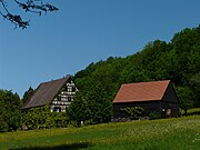
Kaltenherberg (Schnaittach)
|
Kaltenherberg
Schnaittach market
Coordinates: 49 ° 33 ′ 37 ″ N , 11 ° 23 ′ 12 ″ E
|
|
|---|---|
| Height : | 504 m above sea level NHN |
| Residents : | 3 (1961) |
| Postal code : | 91220 |
| Area code : | 09153 |
|
The Schnaittach district of Kaltenherberg
|
|
Kaltenherberg is one of 33 districts of the market Schnaittach in Middle Franconia .
geography
In the Hersbrucker Alb location remote area is located approximately three and a half kilometers east of the center of Schnaittach and is located at an altitude of 504 m above sea level. NHN .
history
The place name means something like non-heatable accommodation, i.e. a hostel that could offer little comfort to those traveling through.
As a result of the administrative reforms carried out in the Kingdom of Bavaria at the beginning of the 19th century , with the second municipal edict in 1818 , Kaltenherberg became part of the independent rural community of Rabenshof, which also included the hamlets of Au , Enzenreuth and Poppenhof , as well as the deserted Finstergarten and Hinterhof .
However, the districts of this community were sometimes quite widely scattered, so that their administrative affairs could only be maintained with relatively great effort. At the beginning of 1930, the local council decided to dissolve the community of Rabenshof. As a result, the community was dissolved on July 1, 1931: Kaltenherberg, the main town and Enzenreuth, as well as the further wasteland backyard became part of the then still independent community of Siegersdorf . Of the remaining parts of the community, Au was assigned to the community of Simmelsdorf and Poppenhof to the former community of Hedersdorf . The wasteland Finstergarten no longer existed at this point.
In the following four decades, Kaltenherberg belonged to the municipality of Siegersdorf, before it was incorporated into the market Schnaittach together with the entire municipality of Siegersdorf in the course of the municipal territorial reform carried out in Bavaria in the 1970s . In 1961 Kaltenherberg had three residents.
traffic
The connection to the road network is made by a local road that leads from Kaltenherberg westwards through the publicly inaccessible area of the deserted backyard and connects the place in Rabenshof to the district road LAU 9, which is about one kilometer away .
Attractions
The Kaltenherberg wasteland is a former hop farm built as a residential stable, with the year "1875" on the upper floor.
See the list of architectural monuments in Kaltenherberg
literature
- Nuremberg country . Karl Pfeiffer's Buchdruckerei und Verlag, Hersbruck 1993, ISBN 3-9800386-5-3
- From Rothenberg and its surroundings, Issue 13 - A historical hike through the Rabenshof district . Heimatverein Schnaittach e. V., 1990
Web links
- Kaltenherberg in the BayernAtlas (accessed October 31, 2017)
- Kaltenherberg on a historical map (accessed October 31, 2017)
Individual evidence
- ↑ Population of Kaltenherberg (1961) on the website of the Bayerische Staatsbibliothek (accessed on October 31, 2017)
- ↑ Kaltenherberg in the location database of the Bayerische Landesbibliothek Online (accessed on October 31, 2017)
- ↑ Geographical location of Kaltenherberg (accessed October 31, 2017)
- ↑ Kaltenherberg on the website of the community of Schnaittach (accessed on October 31, 2017)
- ↑ Heimatverein Schnaittach e. V .: Vom Rothenberg and its surroundings, Issue 13 - A historical hike through the Rabenshof district .
- ^ Wilhelm Volkert (ed.): Handbook of Bavarian offices, communities and courts 1799–1980 . CH Beck, Munich 1983, ISBN 3-406-09669-7 , p. 509 .
- ↑ Political composition of the rural community Siegersdorf (accessed on October 31, 2017)
- ↑ Historical municipality directory for the Federal Republic of Germany (1970-1982) . Page 717


