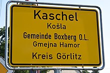
Kaschel
|
Kaschel
Košla Municipality Boxberg / OL
Coordinates: 51 ° 20 ′ 30 ″ N , 14 ° 34 ′ 30 ″ E
|
|
|---|---|
| Height : | 135 m above sea level NN |
| Area : | 6.15 km² |
| Residents : | 132 (Dec 31, 2008) |
| Population density : | 21 inhabitants / km² |
| Incorporation : | April 1, 1938 |
| Incorporated into: | Klitten |
| Postal code : | 02943 |
| Area code : | 035895 |
Kaschel , in Upper Sorbian , is a district of the East Saxon community Boxberg / OL It is part of the official Sorbian settlement area in Upper Lusatia .
geography
In the form of a line village with a round hamlet core, Kaschel is located around three kilometers southwest of Klitten on the state road 121 , which connects the federal road 156 near Lieske with the federal road 115 near Niesky .
To the south of Kaschel there is an extensive forest area of the Upper Lusatian Heath and Pond Landscape Biosphere Reserve , which is bordered to the southwest of Kaschel by Lieske, Neudorf / Spree and Halbendorf / Spree , and by Dauban and Förstgen in the southeast. Jahmen and Klitten are northeast of Kaschel , Zimpel and Tauer to the southeast .
The Hoyerswerda – Horka railway line runs north of Kaschel, the Klitten station of which is located on Jahmener Flur.
history
As Koschele bie deme Cletin , Kaschel was first mentioned in a document in 1419 in a protocol from the Görlitz complaint court. Kaschel has been parish after Klitten since 1555 at the latest.
On a secular level, Kaschel has been associated with the Jahmen estate since the 16th century. The manor house of the manor in Kaschel is expanded into a castle around 1900. It existed in this form until the Second World War, but was blown up by German communists in 1948 for ideological reasons.
On April 1, 1938, several communities in the Rothenburg district (Ob. Laus.) Are amalgamated , including Jahmen , Kaschel and Klein-Oelsa with Klitten.
After the Second World War , the parts of Silesia to the west of the Lusatian Neisse river are connected to the state of Saxony. This ends the 130-year-old Saxon-Prussian demarcation west of the town.
With the merger of the communities Boxberg / OL and Klitten, Kaschel becomes a district of Boxberg on February 1st, 2009.
Population development
| year | Residents |
|---|---|
| 1825 | 184 |
| 1863 | 214 |
| 1871 | 208 |
| 1885 | 192 |
| 1905 | 173 |
| 1925 | 188 |
| 1999 | 158 |
| 2002 | 141 |
| 2008 | 132 |
In 1777 11 possessed men , 3 gardeners and 9 cottagers were working in Kaschel .
In the first population survey, in which the taxable economies are not counted, but every inhabitant is of equal interest, 184 inhabitants are counted in Kaschel in 1825. In the middle of the 19th century the number of inhabitants rose to over 200, but fell below this value again in the last quarter, so that in 1925 there were just four inhabitants more than 100 years earlier in Kaschel.
At the turn of the millennium, the population was 150 with a downward trend.
In the 19th century the population was still predominantly Sorbian. In 1863, according to official figures, 144 of the 214 inhabitants were Sorbs, about 20 years later Arnošt Muka identified 171 Sorbs among the 177 inhabitants. This corresponds to a 67 percent share of the Sorbian population in 1863 and a 97 percent share in 1884. The language change mostly took place in the first half of the 20th century. In 1956 Ernst Tschernik had a Sorbian-speaking population of only 15.7% in the municipality of Klitten, to which Kaschel now belonged.
Place name
Variants of the German place name are Koschele (1419), Kascher (1621), Caschel (1719) and Kaschel (1791). The Upper Sorbian place name Košla is identical to the Sorbian generic name košla, košula "shirt", which is given in Czech as košile , older also košule .
It is unclear whether the name is a mockery of the poverty of the residents, or whether it has been reinterpreted. Ernst Eichler refers to the Czech words košař "basket maker" and košar "pen, hurdle". In 1924, Pohl was of the opinion that the name was derived from kosa "inclined position", "as the terrain descends to the east."
Sources and further reading
literature
- From the Muskauer Heide to the Rotstein. Home book of the Lower Silesian Upper Lusatia District . Lusatia Verlag , Bautzen 2006, ISBN 978-3-929091-96-0 , p. 276 .
Footnotes
- ^ Kaschel in the Digital Historical Directory of Saxony
- ↑ a b From Muskauer Heide to Rotstein , p. 276.
- ^ Ernst Tschernik: The development of the Sorbian rural population (= German Academy of Sciences in Berlin - publications of the Institute for Slavic Studies . Volume 4 ). Akademie-Verlag, Berlin 1954, p. 117 .
- ^ Ludwig Elle: Language policy in the Lausitz . Domowina-Verlag, Bautzen 1995, p. 254 .
- ↑ Ernst Eichler , Hans Walther : Oberlausitz toponymy - studies on the toponymy of the districts of Bautzen, Bischofswerda, Görlitz, Hoyerswerda, Kamenz, Löbau, Niesky, Senftenberg, Weißwasser and Zittau. I name book (= German-Slavic research on naming and settlement history . Volume 28 ). Akademie-Verlag, Berlin 1975, p. 121 .
- ^ Robert Pohl : Heimatbuch des Kreis Rothenburg O.-L. for school and home . Buchdruckerei Emil Hampel, Weißwasser O.-L. 1924, p. 238 .
