Trennfurt Fort
| Trennfurt Fort | |
|---|---|
| limes | ORL 37 ( RLK ) |
| Route (RLK) | Upper German Limes , route 6 ( Main line ) |
| Dating (occupancy) | probably middle of the 2nd century, votive stone from 212 AD |
| Type | Numerus fort |
| size | 88 m × 63 m (= 0.6 ha) |
| Construction | Stone fort, previously suspected of being a wood and earth fort |
| State of preservation | only weak traces of ground, not built over |
| place | Klingenberg am Main - Trennfurt |
| Geographical location | 49 ° 46 '40.4 " N , 9 ° 10' 40.9" E |
| height | 127 m above sea level NHN |
| Previous | Fort Wörth (ORL 36) |
| Subsequently | Miltenberg Old Town Fort (ORL 38) |
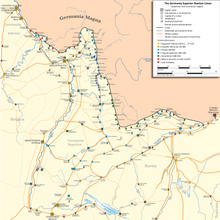
The Trennfurt Fort was a Roman numerus fort in Trennfurt , today a district of Klingenberg am Main , in the Miltenberg district in Lower Franconia . It belongs to the chain of castles of the Main Limes , was in the Roman province of Germania superior and is part of the Unesco world heritage site Upper Germanic-Raetian Limes (ORL). According to the count of the Reich Limes Commission (RLK) it bears the designation ORL 37. The fort is a listed building and is registered in the Bavarian monument list under D-6-6221-0050 . Nothing can be seen of the system above ground today.
location
The former fort is located northeast of the old town center of Trennfurt between the current regulated and dammed Main in the east, which is only about 160 meters away, and the old Roman road Seligenstadt - Miltenberg in the west, more precisely between Trennfurter Straße (formerly B469) in the west and about 200 meters away the Miltenberg-Aschaffenburg railway line east of the fort.
Today, the area of the fort consists mainly of meadows and garden land. The majority is private property and not freely accessible. A small part at the northeast corner of the former fort has been under the railway embankment since the 1870s. To the north it is bounded by the buildings on the south side of Bahnhofstrasse , which flows into Trennfurter Strasse, to the south by an unnamed path that leads at the level of Trennfurter Strasse 51 in the direction of the free slide of today's outdoor pool . The fort is located exactly opposite today's outdoor swimming pool on the western side of the railway embankment. On the east side of the embankment there was an old arm of the Main and the fort is also classified as a port .
In Roman times, a road connection to the older Odenwald Limes at the Hainhaus fort near Vielbrunn is assumed, which is said to have existed as a forest path until modern times and until the excavations of the Imperial Limes Commission. A connection to the Ohrbacher Schanze earthworks in connection with wood felling work for the Mainz region was also suspected and already postulated by Conrady and assigned to the "agens in lignariis" vexillations of the Legio XXII Primigenia Piae Fidelis stationed in Mainz , which have inscriptions from the years 206 to 214 are dated along the main limit.
Research history
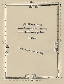
After the discovery of a Roman consecration stone and Roman coins, which Christian Ernst Hanßelmann learned about in 1771 and reported in 1773, it was assumed that a Roman military camp had been located in Trennfurt . Wilhelm Conrady , who later became the route commissioner of the Reich Limes Commission, discovered the fort during excavations that he carried out in 1883 before the Reich Limes Commission was founded. He published the result in 1900 in the excavation reports of the Reich Limes Commission, which did not carry out any more excavations of its own. No more excavations took place at the fort later either. According to Conrady, the surprisingly rectangular fort is about 88 meters long (south-southwest to east-northeast) and 63 meters wide (north-northwest to south-southeast) and occupies an area of slightly less than 0.6 hectares. Only the surrounding walls were excavated. The Praetorial Front in the east could not be excavated because it was affected by the railway embankment. Although it corresponds to the normal size of a numerus fort , with its strongly rectangular shape it differs from the fort shape in the Odenwald and on the Main. The fort was surrounded by only one pointed moat , the simplicity of which Conrady was able to demonstrate on the southern flank of the fort. Conrady also mentions several finds in his excavation report : such as an amphora fragment , several terra sigillata shards, a patera , a folded cup, bowl remains in the shape of a bowl, a roof tile fragment and the iron nails that are usually found. None of the described finds are still available today. The Roman coin finds described in 1773 can no longer be found either.
Dating approach
When the fort was built and how long it was used is unknown. Its period of use can only generally be dated to the middle of the 2nd to the middle of the 3rd century AD. It belonged thus to the Main to 150 n. Chr. Younger brought forward limit (recently Main Limes ), which after the second Miltenberger Fort Miltenberg-Ost then passes continuously to the south. Although there was only a sparse development except for the eastern front of the fort (railway) (two houses in the northeast and northwest), the fort area is no longer superficially recognizable today. This is certainly due to the proximity of the old Trennfurt, which contributed to the fact that all stone material was used for the site, as was the case for the Lützelbach fort until the beginning of the 20th century.
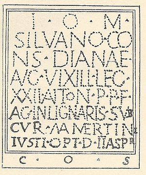
However, an indication of the time is handed down on the Roman consecration stone, which was found in Trennfurt as early as 1751 and which is now walled inside the Trennfurt parish church of St. Maria Magdalena . The consecration stone was originally unprotected on the schoolhouse next to the church. The inscription was almost impossible to read. In 1834 it was walled up in the cemetery, weathered and covered in moss. In 1881 Karl Zangemeister examined the stone again and excerpted the term lignarii . This term for woodworkers had already been proven some time before in Stockstadt and also in Obernburg. Conrady examined the stone in 1899 and deciphered the heavily weathered inscription as follows: “ I (ovi) o (ptimo) m (aximo), Silvano cons (ervatori) Dianae Aug (ustae) vixill (atio) leg (ionis) XXII Anton (initianae) p (rimigeniae) p (iae) f (idelis) ag (entium) in lignari (i) s sub cur (a) Mamertini Iusti opt (ionis) d (edicavit) (duobus) Aspr (is) co (n) s ( ulibus) ". According to today's knowledge, its reading is not entirely correct, but this does not change the content. Thereafter, the stone was dedicated to the gods Jupiter , Silvanus and Diana by a department of the 22nd Legion, which was busy with forest work, in the year when the two Asper were consuls . The two Asper, Gaius Iulius Asper and his son Gaius Iulius Camilius Asper , are recorded as consuls in AD 212. The reconstructed original text was re-hammered into the stone shortly after 1900 - an approach that from today's perspective would be irresponsible.
Another consecration stone dedicated to Neptune was also lost today.
| transcription | in capitals | image |
|---|---|---|
I(ovi) O(ptimo) M(aximo) |
I O M |
It is not clear whether the Legio XXII Primigenia indicated on the consecration stone also represents the occupation of the fort or was only temporarily in the fort for the assumed wood procurement for Mogontiacum .
Conrady already assumed that the fort made of wood for the Roman troops on the Main was being transported, especially since the fort was only about 40 meters away from the old arm of the Main, which could be loaded with ships and rafts. This arm, which separated an area to the east with the field name “Die Insel”, was already silted up at the time of Conrady, but still recognizable in the area, which has not been the case since the redesign of the area with the Main regulation in the 20th century is.
Vicus
An associated vicus and buildings within the fort have not yet been definitively proven, as Conrady only excavated parts of the fort's border. Under Conrady, the vicus was assumed to be on flood-free areas west of the fort. Stray finds south of the fort allow the assumption of a vicus there today. This and the unusual proximity to the neighboring Wörth fort led to the assumption that the fort was not occupied all year round and was only used for the woodwork mentioned above. Against this, speaks that the location of the Trennfurt fort fits better into the regular sequence of the forts of the Main Limes than Wörth, which in this respect could be assigned to the Odenwald Limes. In addition, Conrady had to concentrate on the enclosing walls and gates during his excavation cuts. The question remains unanswered as long as no new on-site investigations are carried out.
legend
The legend can be seen in the realm of fantasy that the place got its name from Emperor Trajan , who moved with his army here over a ford east of the Main ( Trani Vadum ) and is said to have changed as a modified Trajan ford to Trennfurt .
Monument protection
The Trennfurt Fort is under the inventory number D-6-6221-0050 Fort of the Roman Imperial Era ground monument according to the Bavarian Monument Protection Act (BayDSchG). Investigations and targeted collection of finds are subject to approval; random finds are immediately reported to the Lower Monument Protection Authorities or the Bavarian State Office for Monument Preservation.
See also
literature
- Dietwulf Baatz : The Roman Limes. Archaeological excursions between the Rhine and the Danube. 4th edition. Gebr. Mann, Berlin 2000, ISBN 3-7861-2347-0 , p. 215.
- Dietwulf Baatz, Fritz-Rudolf Herrmann: The Romans in Hessen. Licensed edition, Nikol, Hamburg 2002, ISBN 3-933203-58-9 . (P. 482 f. In the 1982 edition)
- Bernhard Beckmann: The Roman Limes Fort Trennfurt . In: Chronicle of the city of Klingenberg am Main. Volume 1. Klingenberg 1994, pp. 33–42 ( digitized version of the city of Klingenberg (PDF file, 46.9 MB))
- August von Cohausen : The Roman border wall in Germany: Military and technical description of the same , 1884, p. 16
- Wolfgang Czysz u. a .: The Romans in Bavaria. Licensed edition, Nikol, Hamburg 2005, ISBN 3-937872-11-6 .
- Britta Rabold, Egon Schallmayer , Andreas Thiel : The Limes. The German Limes Road from the Rhine to the Danube. Theiss Verlag, 2002, p. 69 f.
- Hans Schönberger : The Roman troop camps of the early and middle imperial period between the North Sea and Inn. In: Report of the Roman-Germanic Commission. 66, 1985, p. 478.
- CS Sommer : Fort vicus and fort. In: Find reports from Baden-Württemberg. Volume 13, 1988, pp. 457-707 (therein on Trennfurt, p. 695)
- Bernd Steidl , Ludwig Wamser , Horst Zimmerhackl: Limes World Heritage: Rome's border on the Main. (= Exhibition catalogs of the State Archaeological Collection. 36). Logo-Verlag Erfurth, Obernburg am Main 2008, ISBN 978-3-939462-06-4 , pp. 96-101.
Excavation reports of the Reich Limes Commission :
- Wilhelm Conrady in the series Der Upper Germanic-Raetian Limes of the Roemerreiches (Eds. Ernst Fabricius , Felix Hettner , Oscar von Sarwey ): Department B, Volume 3, Castle No. 37 (1900). 14 pages
Web links
- Trennfurt Fort on the side of the German Limes Commission
- Trennfurt Fort on the side of the museums on the Main Limes
- Epigraphic database Heidelberg: HD011586 , the altar stone Trennfurt
Remarks
- ↑ a b c Bernhard Beckmann: The Roman Limes Fort Trennfurt. P. 36
- ↑ a b c Marcus Nenninger: The Romans and the Forest: Investigations into dealing with a natural area using the example of the Roman north-west provinces. In: Geographica Historica 16. Franz Steiner Verlag, Stuttgart 2001, ISBN 3-515-07398-1 , pp. 175-181.
- ^ (Wilhelm Conrady :) The Trennfurt Fort. Excavated and described by district judge a. D. Conrady. Reprint from the work: Der Obergerm.- Raet. Limes of the Roman Empire. Published by O (scar) on behalf of the Reichs-Limeskommission. from Sarwey, E (rnst). Fabricius, F (elix). Hettner. Verlag Otto Petters, Heidelberg 1900, pp. 1-3.
- ^ (Wilhelm Conrady :) Das Kastell Trennfurt , Heidelberg 1900, pp. 3–8.
- ^ Bernhard Beckmann: The Roman Limeskastell Trennfurt. P. 42, there note 7
- ^ Bernhard Beckmann: The Roman Limeskastell Trennfurt. P. 37
- ^ W. Conrady: The fort separation ford. 1900, p. 13.
- ^ Bernhard Beckmann: The Roman Limeskastell Trennfurt. P. 40; also: CIL XIII, 6618
- ^ Marion Mattern: Roman stone monuments from Hesse south of the Main and from the Bavarian part of the Main Limes. Verlag des Römisch-Germanisches Zentralmuseums, 2005, p. 128 f.
- ^ W. Conrady: The fort separation ford . 1900, pp. 1 and 9 ff.
- ^ W. Conrady: The fort separation ford. 1900, p. 7.
- ↑ Trennfurt Fort. on the side of the German Limes Commission; accessed on March 27, 2018.
- ↑ Castell Trennfurt on museums on the Main Limes ; accessed on March 27, 2018.
- ^ Bernhard Beckmann: The Roman Limeskastell Trennfurt. 1994, pp. 36-38.
- ↑ JF Knapp: Roman monuments of the Odenwald, especially the county of Erbach and the rule of Breuberg. Darmstadt 1854, p. 138, p. 185.
- ↑ Bavarian List of Monuments Klingenberg am Main


