
Häuslingen
| coat of arms | Germany map | |
|---|---|---|

|
Coordinates: 52 ° 49 ' N , 9 ° 24' E |
|
| Basic data | ||
| State : | Lower Saxony | |
| County : | Heidekreis | |
| Joint municipality : | Rethem / Aller | |
| Height : | 16 m above sea level NHN | |
| Area : | 13.58 km 2 | |
| Residents: | 775 (Dec. 31, 2019) | |
| Population density : | 57 inhabitants per km 2 | |
| Postal code : | 27336 | |
| Area code : | 05165 | |
| License plate : | HK | |
| Community key : | 03 3 58 013 | |
| Community structure: | 2 districts | |
| Address of the municipal administration: |
Bahnhofstrasse 18 27336 Häuslingen |
|
| Website : | ||
| Mayoress : | Kathrin Wrobel | |
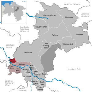
| Location of the community of Häuslingen in the Heidekreis district | ||
  |
||

Häuslingen is a municipality in the Heidekreis district in Lower Saxony .
geography
Häuslingen lies between Rethem (Aller) and Verden (Aller) . The community belongs to the combined community of Rethem / Aller , which has its administrative seat in the city of Rethem (Aller).
The two districts of the community are Groß Häuslingen and Klein Häuslingen.
history
The place was first mentioned in documents in 1220 as "Huchelem". Other names of the place are around 1227 Huochelem, 1229 Huochselem, 1237 Huocselem, 1255 in maiori hucselem, 1295 Wickerim de Hucselem, around 1329 Lutten, Groten Huslem, 15th century Hulsinge, Hulsingen, around 1800 by large and small Häuslingen.
The first settlement was proven in the area of the Hunnenberg. The Hunnenberg is an inland dune. According to Heinrich Imhagen, the former teacher and local chronicle, this name means “Pfahlhausheim” or “Hügelhausheim”. This may be due to the fact that the place in the glacial valley of the Aller is flood-proof on a small hill. Häuslingen means “outstanding hill, mountain, heap” with the addition “-sel-” for “settlement” (also in place names such as Brussels, Bruchsal, Uppsala and others).
After test drilling for potash found 200 m below the surface in 1905 , construction of the shaft began in 1911 and production in 1912. For potash mining, the Verden - Walsrode small railway line ran through the town in 1910. In the following period there was a stormy economic development in the region, which only ended in 1924/25 with the closure of all potash shafts in the Allertal.
After the tunnels were closed, consideration was given to temporarily storing nuclear waste here. Only a few buildings left behind today remind of potash mining, a white potash mountain, a restaurant with the name "Glück auf" and the former railway line, which is now part of a circular hiking trail.
On March 1, 1974, the municipality of Häuslingen was formed through the merger of the previous municipalities of Groß Häuslingen and Klein Häuslingen.
politics
Municipal council
Mayoress: Kathrin Wrobel, 1st deputy mayor: Annedore Blank, 2nd deputy mayor: Jörn Dettmer; MPs: Torsten Gudehus, Ulrich von Behr, Mirko Kunze, Marcel Rischmann, Jannik Taps and Dominic Dreger.
- all of the named are supported by the Häuslinger Bürgerliste
(As of 2016)
mayor
The honorary mayor has been Kathrin Wrobel since 2006.
Former mayors of Häuslingen:
- Alfred Dreyer (1912–1996): 1974–1986
- Armin Kuhr (1952-2000): 1986-2000
- Cort-Brün Voige (* 1962): 2001-2006
coat of arms
Blazon : "Split between red and gold with a shining sun under a rafter in alternating colors."
The name of the community is derived from "house", which is symbolized by the stylized roof (heraldic "rafters"). The coat of arms and thus also the rafter is made up of two halves, as the current municipality of Häuslingen was formed from the two previously independent municipalities of Groß Häuslingen and Klein Häuslingen, which are still recognizable today as two separate districts. The sun is an ancient symbol for life, vitality and happiness. In addition, the sun can also be seen as a symbol of the fact that Häuslingen has been committed to the generation of renewable energies for many years and as one of the first communities. The solar funding program launched at that time was unique in its time and for some time afterwards. The sun is used to create a symbolism that extends from the earliest human history to the future. The colors red and gold stand for centuries of belonging to the Guelph lands, whose coat of arms colors were red and gold.
At the meeting on July 14, 2011, the local council of Häuslingen decided to use a coat of arms. The well-known publicist and heraldist Dr. Arnold Rabbow from Berlin commissioned a coat of arms for the community. From some suggestions, residents of Häusling spoke out in favor of the adopted coat of arms at an official presentation event.

Culture and sights
- The Groß Häuslingen potash heap still reminds of the time of potash mining in this region.
- Directors villas at the beginning of the place.
- The memorial stands in the middle of the village.
- There are a number of listed buildings in the village, both old half-timbered buildings and buildings from the time of potash making.
- Around the former train station there are typical buildings of the Potash era with white house walls and mansard roofs covered with red pans.
- The old school in Groß Häuslingen was built during the potash era.
- A sheepfold from 1706 contains a brick pattern in the half-timbered gable of a thunder broom, which according to old superstitions is supposed to protect against lightning and thunder.
- The manor house of Gut Klein Häuslingen shows an onion dome that is atypical for the region.
- The Potash Cycle Path leads through Häuslingen and shows information on the potash era in Häuslingen on various boards.
- The Aller cycle path also leads through Häuslingen and offers a panoramic view of the Aller and Allermarsch near Häuslingen.
Architectural monuments
Economy and Infrastructure
The A 27 motorway is east of the municipality. The next connection point is approx. 13 km away at Walsrode . The federal motorway 7 also runs east of the municipality. The next junction (Westenholz) is about 24 km away near Hodenhagen . The B 209 federal road , Walsrode– Nienburg / Weser, runs to the south in the immediate vicinity .
Individual evidence
- ↑ State Office for Statistics Lower Saxony, LSN-Online regional database, Table 12411: Update of the population, as of December 31, 2019 ( help ).
- ^ Jürgen Udolph (research): The "place name researcher". In: website NDR 1 Lower Saxony . Archived from the original on November 27, 2015 ; accessed on August 4, 2019 .
- ↑ Groß Häuslingen - former "Aller-Nordstern" shaft
- ^ Federal Statistical Office (ed.): Historical municipality directory for the Federal Republic of Germany. Name, border and key number changes in municipalities, counties and administrative districts from May 27, 1970 to December 31, 1982 . W. Kohlhammer, Stuttgart / Mainz 1983, ISBN 3-17-003263-1 , p. 224 .
- ↑ http://www.haeuslingen.de/formulare/Raete_Gem_Haeuslingen.pdf
- ↑ Chronicle and insights on www.haeuslingen.de
Web links
Ahlden (Aller) | Bad Fallingbostel | Bispingen | Böhme | Buchholz (Aller) | Eickeloh | Essel | Frankenfeld | Gilten | Grethem | Hademstorf | Häuslingen | Hodenhagen | Lindwedel | Munster | Neuenkirchen | Rethem (Aller) | Schneverdingen | Schwarmstedt | Soltau | Walsrode | Wietzendorf
Non- parish district in the district of Heidekreis
Osterheide