Piston mountain
| Piston mountain | ||
|---|---|---|
|
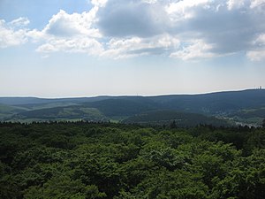
View from the horse head tower over the upper Weil valley to the Kolbenberg with the transmitter mast (center) in the Taunushauptkamm. To the right of it the Hegewiese . To the left of the Kolbenberg the Klingenkopf , in front of it the Weisseberg and a little left in front of it the Great Oak Forest with a part of Dorfweil . Right edge of the picture the Große Feldberg with Arnoldshain below left and Schmitten in front |
||
| height | 690 m above sea level NHN | |
| location | at Oberursel ; Hochtaunuskreis , South Hesse ( Germany ) | |
| Mountains | Taunus | |
| Dominance | 0.88 km | |
| Notch height | 18 m | |
| Coordinates | 50 ° 14 ′ 30 " N , 8 ° 29 ′ 45" E | |
|
|
||
The piston mountain near Oberursel in the southern Hessian Hochtaunuskreis is about 690 m above sea level. NHN high mountain in the Taunus . It is next to the further north-eastern Roßkopf (635- 640 m ) is the only independent collection of Taunus main ridge between wide-field Berg ( 881.5 m ; West South-West) and the Saalburg pass ( 414 m , northeast).
geography
location
The Kolbenberg is located in the Taunus Nature Park . Its summit is located near the borders between Oberursel (southeast), to which it belongs, Schmitten (northwest) and Bad Homburg (east-southeast). The origin of the Urselbach lies south of the Kolbenberg, which is lined with coniferous forest . Beyond or north of the Taunus main ridge are the springs of Aubach and Erlenbach .
Natural allocation
The piston mountain belongs to the natural spatial main unit group Taunus (No. 30) and in the main unit Hoher Taunus (301) to the subunit Feldberg-Taunuskamm (301.3), whereby its landscape to the north belongs to the main unit Eastern Hintertaunus (302) and beyond the Taunush main ridge located subunit horse head-Taunus (302.6) transferred.
Mountain height, dominance and prominence
The piston mountain is about 690 m high. About 50 to 60 m south of the summit, topographic maps show the altitude of 684 m . The dominance of the mountain is 880 m in the direction of the Großer Feldberg , its prominence is 18 m.
Limes and castles
Over the hill of the Klingenkopf ( 682.7 m ; with a prominence of 8 m) to the northeast runs the Roman border wall of the Upper German-Raetian Limes , on which the Roman fort Altes Jagdhaus is located about 440 m northwest of the Kolbenberg ; The foundations of the Roman fort Heidenstock are located on the Eichkopf spur ( 620.2 m ) .
Telecommunication system (Feldberg Relay Site)
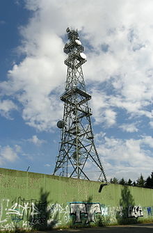
On the extensive summit of the Kolbenberg there is a large telecommunications system with a lattice mast that can be seen from afar, which was used by the US Air Force until 2007 . Since the withdrawal of the US military, the mast has been used by civil radio services, including a. for mobile communications .
There was also a ground radar station for the MGM-1 Matador (Matador Missile), a radio-controlled cruise missile that was stationed in West Germany during the Cold War, well into the 1950s . In the event of a launch, this cruise missile was remotely controlled by ground penetrating radar stations such as the one on Kolbenberg.
The system has been rebuilt and expanded over the years.
The lattice mast was completed in 1962. At first it was painted red and white. The lattice mast is about 100 m high and can be clearly seen from afar. Since then the system has only been used as a radio relay site. At peak times, 20 to 25 antennas were mounted on the lattice mast, which the American soldiers often called "dishes" because they looked like soup bowls.
From the system radio signals were sent north to Obernkirchen / Schwarzenborn, east to Wasserkuppe and south-east to Breitsol / Geiersberg. Radio was sent to the southwest to Wiesbaden and to the northeast in the direction of Stein. The Rhein-Main Airbase and Darmstadt were radioed south. In the west was radio to the Donnersberg.
The system was officially called the "Feldberg Radio Relay Site"; as a result, there was often confusion because there was also a transmitter in the Black Forest on the Feldberg. The area is popularly known as "Sandplacken" or "Kolbenberg".
In the 1960s, only part of the current facility stood, enclosed by a simple wooden fence. At that time about 20 US Air Force employees were stationed there. Most of them worked in the "Telephone Switching Center". In 1969 there were up to 150 employees on site, including “communication personnel” and four cooks in the canteen, as well as 5 employees as “administration personnel”. The employees lived in specially built barracks directly on the premises. In the early 1970s, soldiers set up a small club with a mini-cinema under the barracks on the ground floor; at the same time the wooden fence was replaced by a chain link fence.
In the mid-1980s, the terrorist threat in Germany with groups like the RAF rose rapidly. As the largest radio relay site in Europe was on the Kolbenberg, an approximately 5 m high wall was built around the system. It gave no insight into the interior of the facility, and the entrances through the walls were built in such a way that the facility could not be damaged in the event of a breakthrough with vehicles. At that time, the barracks on the site probably had to give way for reasons of space. From then on, the soldiers lived at Camp King in Oberursel.
The last employee of the US Air Force left the facility in 1993. From then on, it ran independently and was remotely controlled from the Rhein-Main Airbase. Maintenance work took place at regular intervals as well as inspection and monitoring tours.
There were never any underground facilities or bunkers on the Kolbenberg. This has often been claimed because of a translation error on a site map that was distributed across the Internet on various sites and forums. Only the water tank was covered with grass.
Since 2007, a mobile communications provider had rented parts of the system and had antennas installed on the lattice mast, connected to a separate cable route. Various cable thieves and vandals have already discovered the area and left visible traces.
At the beginning of 2018, the "Sandplacken" base station for digital BOS radio was put into operation. Most of the structures above ground, except for the lattice mast, have since been removed.
Military personnel memorial stone
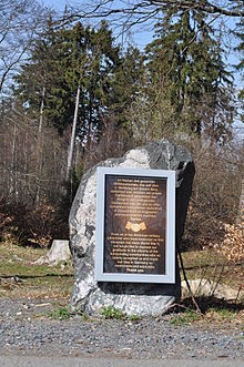
The US soldiers stationed on the Kolbenberg (150 soldiers at times) were popular with the population. The reason for this was the technical support given by the Americans in the construction of a number of facilities in the neighboring towns. Examples are the bobsleigh run in Oberreifenberg , the Kittelhütte refuge (on the mountain pass of the same name) and the sports field in Niederreifenberg . After the withdrawal of the US troops, a memorial stone with a copper plaque was erected about 200 m west-northwest of the Altes Jagdhaus fort near the Sandplacken mountain pass, expressing thanks to the US soldiers for the pleasant cooperation with the residents. The plaque was stolen in August 2011. Thanks to funding from a local company, a new board was installed in March 2012.
Traffic and walking
West past the Kolbenberg the over the mountain pass leads Sandplacken ( 669 m ) extending national road 3004 ( Oberursel - Schmitten ) adapted to close the top of the pass Great field Berg leading L branches 3024th Through its hilltop nearby, the northern highlands run along the limit of the European long-distance path E1 and the Limes trail . The summit can be reached in 10 minutes via the Taunus main ridge, which is flat here, from Sandplacken on forest paths and paths. A scenic access is offered from the southeast from the L 3004 through the valley of the small Urselbach tributary Schellbach (approx. 1 hour), which is lined with light beech forest .
See also
Web links
Individual evidence
- ↑ a b c Map services of the Federal Agency for Nature Conservation ( information )
- ↑ Commissioning of the base station "Sandplacken" on the Großer Feldberg on the side of the Hessen Police, but called on April 22, 2020
- ↑ Alexander Schneider: Place of friendship. In: Taunuszeitung. March 10, 2012, p. 17.
- ↑ Usinger indicator on theft ( page no longer available , search in web archives ) Info: The link was automatically marked as defective. Please check the link according to the instructions and then remove this notice. , on usinger-anzeiger.de.


