
Coordinate system
A coordinate system is used to uniquely identify the position of points and objects in a geometric space.
use
Coordinate systems are aids in mathematics for specifying positions. They are used in many sciences and engineering. Coordinate systems are also frequently used in everyday life:
- For the mathematical description of (physical) reference systems , for example,
- Longitude and latitude form a geographic coordinate system of the earth,
- Hiking maps and city plans are usually divided into coordinate squares. In the square city of Mannheim, the inner city streets form the coordinate system.
- The position of hydrants is described by a coordinate system based on the sign.
- In game notations such as sinking ships or on chessboards and spreadsheets , fields are designated with coordinates such as B3 .
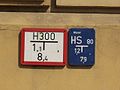
2-dimensional Cartesian coordinates for the localization of hydrants

Mannheim street sign

Chess board

Local map


coordinate
A coordinate is one of several numbers that indicate the position of a point in a plane or in space. Each of the dimensions required for description is expressed by a coordinate. If a place is described by two coordinates, for example on a map, one speaks of a “coordinate pair”.
The technical term of the coordinate - meaning "location information" - was formed in the 18th century from the word ordinate (vertical).
Origin of coordinates, pole
Origin of coordinates (mathematical abbreviation: KOU ) or origin refers to the point in a coordinate system or a map at which all coordinates assume the value zero . It is also called the zero point or, in the case of polar coordinates, the pole .
The coordinate axes often, but not necessarily, run through the origin ( see also: Axis labeling ). In geographic coordinate systems , for example, the equator and prime meridian correspond to the coordinate axes.
Mathematical basics
The position of a point in space is clearly determined in the selected coordinate system by specifying numerical values or size values , the coordinates. Correspondingly, the position of an object ( line , curve , surface , body ) determined by several points can be specified using their coordinates.
The number of values required for description is the dimension of the room. In this sense, a plane is called two-dimensional space. The coordinates of an n- dimensional space are then also understood as n - tuples of real values (more generally: of elements of the underlying body ).
The most frequently used coordinate systems - this is especially true for school mathematics - are the Cartesian coordinate system , more generally the affine coordinate system and the polar coordinate systems .
In projective spaces , a point is represented by its coordinates in relation to a projective coordinate system . These coordinates are also referred to as homogeneous coordinates and are also used in this form for “ordinary” points, which could also be described with affine or Cartesian coordinates. An additional "homogenizing" coordinate is required here, a point in an n -dimensional space is thus described by homogeneous coordinates.

Different coordinate systems
The position of a point in space can be represented in different coordinate systems. The position is expressed by coordinates . Depending on the coordinate system used, the same point has different coordinate values.
Sphere and plane in space
In the case of symmetrical systems, in which one dimension is the same everywhere, one can achieve that individual coordinates remain constant by representation in a suitable coordinate system. For example, to define a position on the earth's surface, it is sufficient to specify only two coordinates ( longitude and latitude ), because the third coordinate is defined by the earth's radius. If, on the other hand, the height of a point should also be described, this must also be recorded as a third coordinate. A height reference surface is also required for this.
Round bodies, for example (approximately) the earth or other celestial bodies, are described by spherical polar coordinates (spherical coordinates). ( Special feature: coordinate singularity )
A plane in space is described with Cartesian coordinates : two coordinates are variable , the third is determined (without loss of generality) by the distance between the plane and the origin of the coordinates.
Straight, crooked and orthogonal
A distinction is made between straight (affine) and curvilinear coordinate systems . In addition, if coordinate lines are perpendicular to each other at every point, such coordinate systems are called orthogonal .

- rectilinear coordinate systems
- affine coordinates , vector space
- rectilinear orthogonal coordinate systems
- Cartesian coordinate system
- curvilinear coordinate systems
- Curvilinear coordinate systems are mostly orthogonal at the same time:
- curvilinear orthogonal coordinate systems
- plane polar coordinates and cylindrical coordinates
- spatial and spherical polar coordinates (spherical coordinates)
- Elliptical coordinates
- Torus coordinates
Transformations between coordinate systems
The transformation between different coordinate systems takes place by means of coordinate transformation . The different numerical values of the n - tuples describe the same position in space. In the transition from straight (affine) coordinates to curvilinear coordinates, the functional determinant (Jacobi determinant) must be used to calculate quantities such as volume .
Special coordinate systems
The space surrounding us is often modeled as three-dimensional Euclidean space in mathematics and physics . If Newton's law of inertia of classical physics applies to this space , one speaks of an inertial system .
Often one dimension of space can be neglected, so that only a two-dimensional space is to be considered. Including the time resulting four-dimensional Minkowski space of relativity .
These spaces can be described by Cartesian coordinates , which are affine (straight-line) coordinates that are measured along axes that are perpendicular to one another.
When describing in polar coordinates , the distance from a specified coordinate origin and angle to given axes are used as coordinates. Here, too, the coordinate axes are perpendicular to one another.
Other coordinate systems are defined in relation to geometric objects ( cylinder , conic section ): cylindrical coordinates, hyperbolic coordinates.
Some coordinate systems that are only used in specialist areas (e.g. geodesy , cartography , geography , remote sensing , astronomy , amateur radio ) are:
- Geodetic coordinate system
- Geographic coordinate system
- Soldner coordinate system
- Gauss-Krüger coordinate system
-
UTM coordinate system
- UTM reference system also MGRS
- Astronomical coordinate systems such as the ecliptical or galactic
- Barycentric coordinates
- Trilinear coordinates
- Parallel coordinates
- Moving coordinate systems
- Rotating coordinate systems
- Vehicle coordinate system
- World coordinate system
- QTH locator
Basis vectors in the coordinate system
For coordinate systems, the term "basis vector" has a slightly different meaning than for the basis vector of a vector space . A basis vector (for any point) is then a vector that is tangent to a certain coordinate line at that point. It follows from this that basis vectors in the coordinate system form a basis in the coordinate system, which is generally to be distinguished from the basis of a vector space.
Particularly in the case of curvilinear coordinates , a distinction is made between local base and global base . (See section " Different Bases " in the article "Curvilinear Coordinates".) A global base exists when every point has the same base vectors, which is e.g. B. is the case with Cartesian coordinates . Otherwise each point has its own basis vectors, which form the local basis of this point.
A base in a finite-dimensional vector space can, however, be understood as the global base of a coordinate system. For example, the basis vectors of a Euclidean vector space form the basis of a Cartesian coordinate system.
If you want to use a different coordinate system, you have to carry out a coordinate transformation , of which the linear transformation is a special type. It has the property that it can be represented as a linear mapping or as a matrix .
Right and left handed coordinate systems

A coordinate system is differentiated not only by the norm, ie the length “1”, the degree or curvature of the main axes, ie the coordinate axes and the angles between the coordinate axes, but also by the orientation and direction of rotation of the coordinate system. Both properties together describe the relationship between the coordinate axes in the case of a rotational transformation of one axis into another.
A distinction is made between right-handed and left-handed coordinate systems, with right-handed coordinate systems having a mathematically positive sense of rotation as agreed. The so-called three-finger rule of the right hand is used to check whether a three-dimensional Cartesian coordinate system adheres to the right-handed axis orientation customary for this purpose .
The definition using the clockwise direction is better and clearer: the first coordinate is swiveled into the second by the shortest possible route. In the right-handed coordinate system, the positive direction of the third coordinate results from the direction of movement of a right-hand screw.
See also
Web links
- Simple and understandable explanation (mostly through illustrations)
- Mathematically exact definitions (with formulas)
- Eric W. Weisstein : Coordinate System . In: MathWorld (English).
Individual evidence
- ^ Etymology according to Kluge Etymological Dictionary of the German Language , 24th edition, 2002.
- ↑ Torsten Fließbach: Mechanics. Textbook on theoretical physics I . 7th edition. Springer Spectrum, Berlin / Heidelberg 2015, ISBN 978-3-642-55432-2 , p. 5 .