Kotthausen (Wuppertal)
|
Kotthausen
City of Wuppertal
Coordinates: 51 ° 13 ′ 48 ″ N , 7 ° 18 ′ 7 ″ E
|
||
|---|---|---|
| Height : | 295 m above sea level NHN | |
|
Location of Kotthausen in Wuppertal |
||
|
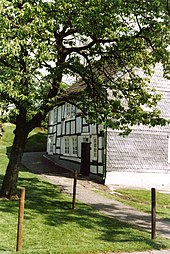
View in Kotthausen (2001)
|
||
Kotthausen is a court in the Wuppertal residential area of Herbringhausen in the Langerfeld-Beyenburg district . The houses with the numbers three to six are under monument protection .
geography
The yard is 295 m above sea level. NHN at the city limits to Radevormwald . The Lohbach , a tributary of the Wupper, rises near the Hofschaft . Neighboring places are Rottland , Nöllenberg , Oberdahl , Auf'm Hagen and Walbrecken .
history
In the Middle Ages, Kotthausen, first mentioned in 1350, belonged to the Honschaft Walbrecken in the parish of Lüttringhausen of the Beyenburg office along with 15 other farms . In 1411 Count Adolf VII von Jülich-Berg certified the freedom of the estate and the status of a saddle farm , in 1425 this privilege was confirmed.
In 1547 a list of manual and tensioning services shows that there was a dwelling. At that time the court was part of the Mosblech court association , which was an allod of the Bergisch dukes . In 1597 the status of Kotten becomes clear in a list of treasure and service goods . In 1715 the hamlet is called Kotthusen on the Topographia Ducatus Montani .
In 1815/16 there were 41 people living in the village. In 1832 Kotthausen was still part of the Walbrecken Honschaft, which now belonged to the Lüttringhausen mayor . According to the statistics and topography of the Düsseldorf administrative district , the place called a hamlet had five residential buildings, five agricultural buildings and three manufacturing facilities at that time. At that time there were 100 residents, eight Catholic and 92 Protestant. In the municipality lexicon for the Rhineland province from 1888, six houses with 66 inhabitants are given.
Individual evidence
- ↑ a b c Gerd Helbeck : Beyenburg. History of a place on the Bergisch-Mark border and its surrounding area. Volume 1: The Middle Ages. Basics and advancement. Association for local history, Schwelm 2007, ISBN 978-3-9811749-1-5 .
- ↑ Gerd Helbeck: The Bergische Landwehr between Wupper, Ennepe and Bever. In: Romerike Berge. Vol. 53, issue 3, 2003, ISSN 0485-4306 , p. 2 ff.
- ^ Hermann Kießling: Courtyards and farm associations in Wuppertal. Bergisch-Märkischer Genealogischer Verlag, Wuppertal 1977.
- ↑ Johann Georg von Viebahn : Statistics and Topography of the Administrative District of Düsseldorf , 1836
- ↑ Königliches Statistisches Bureau (Prussia) (Ed.): Community encyclopedia for the Rhineland Province, based on the materials of the census of December 1, 1885 and other official sources, (Community encyclopedia for the Kingdom of Prussia, Volume XII), Berlin 1888.
literature
- Wilhelm Engels : The free court Kotthausen and the other saddle goods in the area of the Beyenburg office. In: Journal of the Bergisches Geschichtsverein . Vol. 67, 1939, pp. 20-28


