
Kythnos
|
Kythnos municipality Δήμος Κύθνου (Κύθνος) |
|||
|---|---|---|---|
|
|||
| Basic data | |||
| State : |
|
||
| Region : | South Aegean | ||
| Regional District : | Kea-Kythnos | ||
| Geographic coordinates : | 37 ° 23 ' N , 24 ° 25' E | ||
| Area : | 100.187 km² | ||
| Residents : | 1,456 (2011) | ||
| Population density : | 14.5 inhabitants / km² | ||
| Community logo: |
|
||
| Seat: | Chora Kythnou | ||
| LAU-1 code no .: | 6302 | ||
| Districts : | no | ||
| Local self-government : | 2 local communities | ||
| Website: | www.kythnos.gr | ||
| Location in the South Aegean region | |||
 |
|||

The Greek island of Kythnos ( Greek Κύθνος [ ˈkʲiθnɔs ] ( f. Sg. )) Is one of the western Cyclades . Together with the rocky island of Piperi, it forms a municipality (δήμος, Dimos ) in the South Aegean region . 1456 inhabitants live on the island, 561 of them in the capital of the same name.
geography
location
Together with Kea , Serifos and Sifnos , Kythnos forms the western north-south island chain of the Cyclades. Kythnos is about 11.5 km southeast of Kea and more than 13 km north of Serifos. The island of Syros is 33 km and the uninhabited island of Piperi 8.7 km to the east. From Cape Kefalos in the north to Cape Agios Dimitrios the length is about 21 km. The width in east-west direction is between 8.6 km and 3.6 km. The area is 99.432 km².

The morphology of the island is characterized by hilly to mountainous terrain, as well as a strongly indented coast with countless small bays. The island is dominated by two mountain ranges running from north-northeast to south-southwest. The smaller one in the northwest is aligned almost parallel to the coast and with the Kakovolo (Κακόβολο 356 m) represents the highest point on the island. On the northeast coast is the Loutra spa (Λουτρά) at the bay of the same name ( Ormos Loutron Όρμος Λουτρών). The mountain ranges are separated by the plateau with the main town Kythnos at about 100 m. The Profitis Ilias east of Kythnos is the highest point of the second mountain range at 326 m. This is initially lower towards the south. The Petrovouni (Πετροβούνι 211 m) and the Agios (΄Αγιος 263 m) form the transition to the Larni-Merovigli mountain range (Λάρνι-Μεροβίγλι) south of Dryopis, the highest point is 318 m. After that the island tapers noticeably, the heights reach around 200 m. The terrain is rugged with partly steep rocky coasts. Numerous small dry streams drain the winter precipitation, the catchment areas are less than 2 km².
history
Archaeological excavations have revealed a Mesolithic settlement with some graves from the 9th millennium BC near Maroulas in the northeast . Exposed. It is the oldest known place in the Cyclades. The mining and smelting of copper during the early Bronze Age ( FK II ) is known from several sites. The Skouries site shows that the natural local conditions were used to melt away. Numerous artifacts give evidence of the extraction of copper . In addition, several round buildings made of slate are interpreted as melting furnaces. Since copper was also processed by Sifnos , Skouries is regarded as a site specializing in the extraction of copper and a central copper smelter in the Aegean. Analyzes confirm the trade of the molten copper to the mainland and to Crete. In 2002–2006 a double temple from the archaic period, which was destroyed by an earthquake and presumably consecrated to Apollo and Artemis , was uncovered under the direction of Alexander Mazarakis Ainian in the old capital Vryokastro .
Community structure
The community of Kythnos is divided into two local communities. According to the 2011 census, it had 1,456 inhabitants. These live mainly in the two largest towns, Messaria or Kythnos (locally also Chora , 561 inhabitants) and Dryopis (locally also Chorio, 325 inhabitants).
| Local community | Greek name | code | Area (km²) | 2001 residents | Residents 2011 | Villages and islands |
|---|---|---|---|---|---|---|
| Kythnos | Τοπική Κοινότητα Κύθνου | 63020001 | 49.961 | 746 | 787 | Kythnos, Agia Irini, Agios Stefanos, Apokrisi, Loutra |
| Dryopis | Τοπική Κοινότητα Δρυοπίδος | 63020002 | 50.226 | 862 | 669 | Dryopis, Agios Dimitrios, Aosa, Gandromandra, Episkopi, Kalo Livadi, Kanala, Lefkes, Liotrivi, Merichas, Piperi, Skylos, Flambouria |
| total | 6302 | 100.187 | 1608 | 1456 | ||
Infrastructure
traffic
From the port in Merichas there are regular connections with Lavrio , Piraeus and the neighboring islands.
The two buses for local public transport are privately owned. The routes from Merichas via Kythnos to Loutra and from Merichas via Dryopis to Panagia Kanala are served.
A helipad is available for emergencies .
power supply
Until the commissioning of Europe's first wind farm, Kythnos was supplied exclusively by an oil power station . In 1982 five wind turbines with an output of 100 kW were integrated into the supply network. A 100 kW photovoltaic system followed a year later. Both systems were later integrated into an autonomous central hybrid power plant. The system has been continuously developed and expanded as part of several EU-funded projects. Under optimal conditions, the hybrid power plant achieves an output of 765 kW. The diesel generator sets can be switched off completely if there is less power required.
economy
Even today, fishing and the rather poor agriculture on the barren island are the main sources of income. As a holiday island, Kythnos is mainly visited by Athenians . The Katafiki show cave is located near Dryopis . In Loutra there is also a small thermal bath with hot springs for gynecological problems.
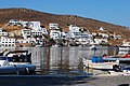
Merichas, the berth for the ferries

Kolona beach near Merichas

Loutra, a small port with hot springs

Loutra hot spring water


Web links
- Kythnos: website of the local government (English)
- General information about Kythnos, Aegean Portal (English)
Individual evidence
- ↑ a b Results of the 2011 census, Greek Statistical Office (ΕΛ.ΣΤΑΤ) ( Memento from June 27, 2015 in the Internet Archive ) (Excel document, 2.6 MB)
- ↑ Ελληνική Στατιστική Αρχή [ΕΛΣΤΑΤ] (Ed.): Στατιστική Επετηρίδα της Ελλάδος (Statistical Yearbook of Greece) 2009 & 2010 . Piraeus 2011, p. 47 .
- ↑ Maroulas on Kythnos, Foundation of the Hellenic World (English)
- ↑ Eva Alram-Stern (ed.): The Aegean Early Period. 2nd series. Research report 1975–2002 . The Early Bronze Age in Greece with the exception of Crete. Publishing house of the Austrian Academy of Sciences, Vienna 2004, ISBN 978-3-7001-3268-4 , p. 856-858 .
- ↑ Alexandros Mazarakis Ainian: An ancient sanctuary on Kythnos. In: Heide Frielinghaus , Jutta Stroszeck (ed.): New research on Greek cities and sanctuaries. Festschrift for Burkhardt Wesenberg on his 65th birthday (= contributions to the archeology of Greece. Volume 1). Bibliopolis, Möhnesee 2010, ISBN 978-3-933925-91-6 , pp. 21-53.
- ↑ Island grids with a high proportion of renewable energies on the Greek island of Kythnos, Kassel Symposium on Energy System Technology ( Memento from February 28, 2013 in the Internet Archive ) (PDF; 482 kB)