
Heidenstock small fort
| Heidenstock small fort | |
|---|---|
| Alternative name | Heidenstock fort on Eichkopf, Heidenstock intermediate fort, Wp 57 |
| limes | ORL - ( RLK ) |
| Route (RLK) |
Upper German Limes , route 3 Hochtaunus route |
| Dating (occupancy) | probably from the middle of the 2nd century to AD 259/260 at the latest. |
| Type | Small fort |
| unit | unknown vexillatio |
| size | 19.40 × 23.40 m (= 0.04 ha) |
| Construction | stone |
| State of preservation | The masonry on the north corner is visibly preserved, the rest is protected under an earth wall. |
| place | Bad Homburg vor der Höhe |
| Geographical location | 50 ° 15 '13.5 " N , 8 ° 30' 46.4" E |
| height | 610 m above sea level NHN |
| Previous | Small fort Altes Jagdhaus (southwest) |
| Subsequently | ORL 11 Saalburg Castle (northeast) |

The Heidenstock small fort was a Roman military camp that was built on the Upper Germanic-Rhaetian Limes , a UNESCO World Heritage Site , on its course through the natural area of Hoher Taunus . The fortification is located around five kilometers southwest of the Saalburg fort in a wooded and uninhabited exclave of the Bad Homburg district of Ober-Eschbach in the Hessian Hochtaunuskreis .
location
The clearly visible facility is located in the Taunus on the border of the cities of Bad Homburg vor der Höhe and Neu-Anspach . Near the belonging to Ober-Eschbach fortlet are that too at Bad Homburg scoring Dornholzhausen and to Schmitten belonging Arnoldshain . In the Taunus Nature Park , the fortification is around 610 m above sea level. NHN at the Eichkopf (620.2 meters), a northeast spur of the Klingenkopf (682.7 meters). Passes in the portion between the Saalburg and the Taunus pass on Sandplacken (about 669 m ), the limit with the Limes trail .
Due to its lower position in front of the height of the Eichkopf, the crew of the small fort and the surrounding towers only had a limited view of the Limes foreland. This restriction applies to many areas of the Roman border fortifications in the Taunus, since the Limes there is basically based on the mountain ridges, but mostly remains somewhat below the highest elevations. With a move just a few meters higher, the soldiers would have had all the important strategic and tactical advantages on their side. The waiver of the better topographical location - at least during the early construction phase at the time of the construction of the barriers - cannot be explained in four places and remains speculative. For the classical scholar Theodor Mommsen (1817–1903) the partially unfavorable course of the Limes remained “strange”. Later attempts to look for a militarily more favorable border demarcation can only be documented for a few areas in the Taunus.
Research history
Jacobi and Cohausen excavated the remains of the building in July 1892, the year the Imperial Limes Commission was founded . At that time, the surrounding wall was still up to 1.80 meters high. After the investigation, the wall to the west of the entrance was "freshly put on" up to a height of 2.20 meters. The complex was still largely in this condition in 1932. The result of the massive stone robbery that the small fort later found out was not documented until long after the Second World War . The archaeologist Dietwulf Baatz reports in 1972 and 1993 of a clearly visible, crumbled stone wall. In the course of the planned redesign of the area, the forest above the fort area was cleared in 2008. The actual new conservation and a slight brick-up of the north corner to the post-war level took place in spring 2009. The rest of the defensive wall is secured against renewed destruction by an earth filling.
The name "Heidenstock" shows that the small fortification has long been anchored in the minds of the local population. The name is based on the false assumption that the remains of the wall are a customs station (folding rule), the pagan Romans. Despite its remote location, the so-called “butcher's path” crossed the Limes and Taunushauptkamm in the vicinity of the small fort. It is an old road that connected the Usinger Land with the Vordertaunus. Hence the idea of a customs office. In the early Limes literature, the small fortification is also called "Am Einsiedel" by its excavators, Louis Jacobi (1836–1910) and Karl August von Cohausen (1812–1894). However, the Reich Limes Commission decided on the name Heidenstock.
Building history
The rectangular fortification was built around the middle of the 2nd century AD, possibly to reinforce the border line afterwards. The fort area measures 19.40 × 23.40 meters (440 square meters) and is around twelve meters behind the Limes border fortifications. Heidenstock has the rounded corners of the enclosing wall (playing card shape) typical for garrison places of the Principate's time . The thickness of these walls was measured at 1.90 to 2.05 meters. To secure the apron, the small fort had a four-meter-wide trench in front of an approximately one-meter-wide berm , which was still around 1.20 meters deep and exposed in front of the only northwest-oriented gate. The 3.10 meter wide entrance faced the Limes and thus the Barbaricum . The walls were set as mortar-free dry masonry made of roughly worked rubble stones. The stone material used consisted of existing Taunus quartzite . In order to increase the stability of the system, the stones could have been set in clay. Two remains of the foundations of further dry stone walls that were found in the south-west half belonged to the interior development. Jacobi also uncovered a fireplace there, which was almost directly on the southeast wall. The fire rubble, which was also found in the southern half, which was mixed with large amounts of clay, allows the conclusion that the Roman garrison era ended with a large fire.
According to better-known systems, the interior development will have consisted of half-timbered structures that were mounted on dry stone walls. The clay found could thus have been processed in the compartments. Jacobi and Cohausen saw the lack of roof tiles as an indication that the building cover must have consisted of perishable material.
It can be assumed that the crew consisted of a small watch division of around 20 men. This could have been ordered here from the Saalburg .
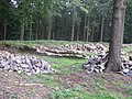
After clearing, before re-conservation, 2008

The restored stumps of the wall in 2009

North elevation with the ancient entrance

One of the rounded corners of the enclosing wall
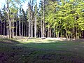
View over the storage area from the west

View from the Limes and Taunushöhenweg, looking south


Finds
The finds that the Imperial Limes Commission was able to determine included a bronze coin each from the reign of Emperor Hadrian (117–138) and Mark Aurel (161–180). The military equipment included a hinge brooch , a disc brooch and a swastika brooch, all three made of white metal . In addition, the 7.50 centimeter long remains of a sword scabbard fitting, two iron lance tips and a square arrowhead were recovered. The tools of daily use included a mason's hammer, the remains of a knife and scissors, and a sliding key. A millstone made from Mendiger Lava proved that the garrison of Heidenstock, as is customary in the Roman army, had to grind the grain they delivered themselves. In addition to ordinary earthenware, fragments of terra sigillata were part of the findings. This included a sigiloid base , which was stamped DOLCCVS F (ecit) (made by Dolccus) and was made in an East Gaulish pottery. Two pierced blue glass beads from the list of finds are more likely to be associated with civil life.
Monument protection
The Heidenstock small fort and the adjoining Limes structures have been part of the UNESCO World Heritage as a section of the Upper German-Raetian Limes since 2005 . In addition, they are ground monuments according to the Hessian Monument Protection Act . Investigations and targeted collection of finds are subject to approval, and accidental finds are reported to the monument authorities.
Limes course from the small fort Heidestock to the Saalburg fort
After the small fort (also marked as Wp 3/57) the course of the Limes continues in a north-easterly direction along the ridge of the Taunus over the ridge of Einsiedler (607 m), Roßkopf (632 m), Kieshübel (633 m) and Hollerkopf (616 m), to then descend to the Saalburg Pass down to about 415 meters. This pass was protected by the famous Saalburg castle . The towers Wp 3/58 to 3/66 were located between the two forts, of which three (59, 60, 62) have been identified and two more (61 and 63) have been preserved. Four tower sites were identified at Wp 3/59, 3/61 and 3/63.
See also
literature
- Dietwulf Baatz , Fritz-Rudolf Herrmann (ed.): The Romans in Hessen , Theiss, Stuttgart 1982, ISBN 3-8062-0267-2 , p. 391.
- Karl August von Cohausen : Roman antiquities. In: Annalen des Verein für Nassauische Altertumskunde und Geschichtsforschung 25, Berchtold & Comp., Wiesbaden 1893, pp. 25–36; here, p. 26.
- Dietwulf Baatz : The Roman Limes. Archaeological excursions between the Rhine and the Danube. 3. Edition. Gebr. Mann, Berlin 1993, ISBN 3-7861-1701-2 , p. 134.
- Ernst Fabricius , Felix Hettner , Oscar von Sarwey (Hrsg.): The Upper Germanic-Raetian Limes of the Roemerreiches / Abt. A, volume 2.1. The routes 3 to 5. Petters, Heidelberg / Berlin / Leipzig 1936, p. 39 as well as plate 8, fig. 6, p. 118–119.
- Christian Fleer: Typification and function of the small buildings on the Limes. In: E. Schallmayer (Ed.): Limes Imperii Romani. Contributions to the specialist colloquium “Limes World Heritage Site” in November 2001 in Lich-Arnsburg. Bad Homburg v. d. H. 2004, ISBN 3-931267-05-9 , pp. 75–92 (Saalburg-Schriften 6)
- Margot Klee : The Roman Limes in Hessen. History and sites of the UNESCO World Heritage. Pustet, Regensburg 2009, ISBN 978-3-7917-2232-0 , p. 111.
- Margot Klee: The Limes between Rhine and Main . Theiss, Stuttgart 1989, ISBN 3-8062-0276-1 , p. 77.
Web links
Remarks
- ^ Wilhelm Schleiermacher: The Roman Limes in Germany: an archaeological guide for road trips and hikes. Verlag Gebr. Mann, Berlin 1961, p. 94
- ↑ Map services of the Federal Agency for Nature Conservation ( information )
- ↑ Stefan Rebenich , Gisa Franke (eds.): Theodor Mommsen and Friedrich Althoff. Correspondence 1882–1903 . Oldenbourg, Munich 2012, ISBN 978-3-486-70104-3 , p. 490.
- ↑ a b c d e f Ernst Fabricius , Felix Hettner , Oscar von Sarwey (ed.): The Upper Germanic-Raetian Limes of the Roemerreich / Abt. A, volume 2.1. The routes 3 to 5. Petters, Heidelberg / Berlin / Leipzig 1936, p. 39 as well as plate 8, fig. 6, p. 118.
- ↑ a b Dietwulf Baatz: The Limes from the Saalburg to the Feldberg Fort. In: Kurt Böhner : Guide to prehistoric and early historical monuments. Hochtaunus, Bad Homburg, Usingen, Königstein, Hofheim . Volume 21, von Zabern, Mainz 1972, p. 175.
- ↑ Dietwulf Baatz: The Roman Limes. Archaeological excursions between the Rhine and the Danube . Mann, Berlin 1993, ISBN 3-7861-1701-2 , p. 134; Margot Klee: The Limes between Rhine and Main . Theiss, Stuttgart 1989, ISBN 3-8062-0276-1 , p. 77 (photo).
- ↑ Heidenstock Fort - a woman visiting the Limes. In: Frankfurter Rundschau. April 21, 2009; accessed on August 16, 2014.
- ↑ Alexander Wächtershäuser: More than “just” Roman history. The names of the Limes fort. In: Yearbook of the Hochtaunuskreis 2009. ISBN 978-3-7973-1110-8 , p. 126.
- ^ Margot Klee : The Roman Limes in Hesse. History and sites of the UNESCO World Heritage. Pustet, Regensburg 2009, ISBN 978-3-7917-2232-0 , pp. 99-103.
- ↑ Dietwulf Baatz , Fritz-Rudolf Herrmann (ed.): Die Römer in Hessen , Theiss, Stuttgart 1982, ISBN 3-8062-0267-2 , p. 391.
- ↑ a b c d Karl August von Cohausen : Roman antiquities. In: Annalen des Verein für Nassauische Altertumskunde und Geschichtsforschung 25, Berchtold & Comp., Wiesbaden 1893, pp. 25–36; here, p. 26.
- ^ Margot Klee: The Limes between Rhine and Main . Theiss, Stuttgart 1989, ISBN 3-8062-0276-1 , p. 77.
- ↑ a b Ernst Fabricius , Felix Hettner , Oscar von Sarwey (ed.): The Upper Germanic-Raetian Limes of the Roemerreich / Abt. A, volume 2.1. The routes 3 to 5. Petters, Heidelberg / Berlin / Leipzig 1936, p. 39 and plate 8, fig. 6, p. 119.
- ↑ Ernst Fabricius , Felix Hettner , Oscar von Sarwey (ed.): The Upper Germanic-Raetian Limes of the Roemerreiches / Abt. A, volume 2.1. The routes 3 to 5. Petters, Heidelberg / Berlin / Leipzig 1936, p. 39 as well as plate 8, fig. 6, p. 159.
- ↑ Ernst Fabricius , Felix Hettner , Oscar von Sarwey (ed.): The Upper Germanic-Raetian Limes of the Roemerreiches / Abt. A, volume 2.1. The routes 3 to 5. Petters, Heidelberg / Berlin / Leipzig 1936, p. 39 as well as plate 8, fig. 6, p. 160.
- ↑ Ernst Fabricius , Felix Hettner , Oscar von Sarwey (ed.): The Upper Germanic-Raetian Limes of the Roemerreiches / Abt. A, volume 2.1. The routes 3 to 5. Petters, Heidelberg / Berlin / Leipzig 1936, p. 39 as well as plate 8, fig. 6, p. 158.
- ↑ Ernst Fabricius , Felix Hettner , Oscar von Sarwey (ed.): The Upper Germanic-Raetian Limes of the Roemerreiches / Abt. A, volume 2.1. The routes 3 to 5. Petters, Heidelberg / Berlin / Leipzig 1936, p. 39 as well as plate 8, fig. 6, p. 165.
- ↑ Wp = W oh p east, watch tower. The number before the slash denotes the Limes section, the number after the slash denotes the respective watchtower. An additional asterisk (*) refers to a guard on the older Limes line.
.jpg)