List of cultural monuments in Buchen (Odenwald)
The list of cultural monuments in Buchen includes immovable architectural and artistic monuments from all parts of the city of Buchen . The basis for this list is the list of architectural and art monuments published by the Karlsruhe Regional Council as of February 15, 2012.
This list is not legally binding. Legally binding information is only available on request from the Lower Monument Protection Authority of the city of Buchen.
Architectural and cultural monuments of the city of Buchen
Buchen (core city)
Architectural, artistic and cultural monuments in the core city of Buchen:
![]() Map with all coordinates of the cultural monuments in the district of the central city of Buchen: OSM
Map with all coordinates of the cultural monuments in the district of the central city of Buchen: OSM
| image | designation | location | Dating | description |
|---|---|---|---|---|
| building | Abt-Bessel-Strasse 7 (map) |
16th century - 21st Century | Former land consolidation office , today social station, two-storey solid building, half-hip roof.
|
|
 More pictures |
Medieval city fortifications | Am Haag 1 (map) |
13th century | This eastern part of the former city wall is partially integrated into the development, but part of a tour around the old town. A piece of the medieval battlement can be seen. The round “thief tower”, however, once stood elsewhere and was rebuilt here.
|
 |
Lourdes Chapel | Am Haag 2 (map) |
19th century | Small rectangular building in neo-Romanesque forms, triangular closure, gable rosette, stepped gable; Late 19th century.
|
 More pictures |
Holy Cross Chapel | Amtsstrasse 15 (map) |
16th century - 18th century Century | Catholic chapel Zum Hl. Kreuz, baroque hall building 1704, three-sided closure, roof turret, cripple hip gable, next to the entrance portal a relief of the cross (probably early 17th century); Interior fittings in part from the 16th and 18th centuries.
|
|
|
District Office | Amtsstrasse 26 / Dr.-Konrad-Adenauer-Strasse 2 (map) |
1844 | Formerly the grand ducal district office, today the district court , multi-part complex with two-storey sandstone blocks in romantic classicism based on plans by August Moosbrugger (1802–1858); Main building at the entrance portal marked 1855, former prison (Konrad-Adenauer-Str. 2) dated 1844, intermediate building 1895.
|
 More pictures |
Railway station hotel | Eisenbahnstrasse 1 (map) |
Former hotel building erected in 1905 opposite the station building.
|
|
| railway station | Eisenbahnstrasse 4 (map) |
19th century | Station on today's Seckach – Miltenberg railway , two-storey sandstone building with a gable projections and single-storey side wings, end of the 19th century.
|
|
 More pictures |
Belzsches Haus (former winery) | Haagstrasse 10 (map) |
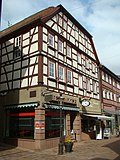
1618 | Residential and economic building of the former winery (see below); two-storey half-timbered eaves house with solid ground floor, in the core 15./16. Century. (partly changed), north side: window frames 1617, portal marked 1623, south side: portal marked 1618 (cf. Kellerereistraße 25, 27).
|
 More pictures |
Marian column beech | Hochstadtstrasse 2 (near), Marktstrasse, Platz Am Bild (map) |
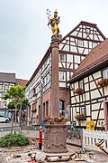
The Marian Column , erected in 1754, is a protected cultural monument and a symbol of the Madonna Land .
|
|
| Medieval city fortifications | Hochstadtstrasse 22 | 13th century |
|
|
| Medieval city fortifications | Kellereistraße 16, 18, 24, 28, 29, 30, 32, 34, 36, 40, 42, 42a, 48 (map) |
13th century | Section of the southern city fortification with city wall and directly adjoining wide ditch.
|
|
 More pictures |
Zehntscheune (former winery) | Kellereistraße 25 (map) |
16th century - 17th Century | Former tithe barn of the Electoral Mainz office cellars; two-storey solid construction, 16./17. Century, courtyard-side portal marked 1627, with Baroque coat of arms ( Georg Friedrich von Greiffenclau zu Vollrads ), old surrounding wall.
|
 More pictures |
Trunzerhaus (former winery) | Kellereistraße 27 (map) |
16th century - 18th century Century | In the half-timbered building with bricked ground floor from the beginning of the 16th century was the apartment of the official cellar . The German-Swedish composer and court conductor Joseph Martin Kraus (1756–1792) lived there in his youth . 1901–1927 home of Karl Trunzer , the founder of the Buchen District Museum .
|
 More pictures |
Steinerner Bau (former winery) | Kellereistraße 29 (map) |
15th century | Solid stone building with a striking bay window , was built in 1493 under the Archbishop of Mainz, Berthold von Henneberg . Contains the main part of the collection presentation of the district museum.
|
 |
Medieval city fortifications | Linsengasse 6, 10, 12, 14, 22, 26 (map) |
13th century | In this, southern section of the city fortifications, a wide moat with gardens of the residents has been preserved directly outside the city wall. One of the four gate towers, the sea gate, used to be located here.
|
| Medieval city fortifications | Marktstrasse 1, 2, 3, 4 | 13th century |
|
|
 More pictures |
Mainzer Tor (city tower) | Marktstrasse 4 (map) |
1309 | Gate tower; medieval city gate (around 1490; facility older); ogival passage with cross vault, six storeys, the east side originally open, closed in 1717; Roof, lantern and bells 1718/19 (city landmark).
|
 |
Residential and commercial building | Marktstrasse 13/15 (map) |
Residential and commercial building
|
|
 More pictures |
Residential and commercial building | Marktstrasse 23 (map) |
19th century | Residential and commercial building, probably built in the 19th century. The three-story, plastered half-timbered house has a massive ground floor. The mansard roof was built in 1910. The corner bay window is the characteristic feature of the building. It ends with a slate-covered hood.
|
 More pictures |
Old Town Hall | Marktstrasse 25 (map) |
1719-1723 | Old town hall, built 1719–23. Two-storey, baroque solid building with richly structured sandstone facade and open ground floor hall (three arched openings each on the gable, west and east side), bell gable, roof turret. Back to the parish church with a passage arch and stairs, side ear portal (town landmark).
|
 More pictures |
Former residential building, "Kiesersches Haus", music school | Obergasse 1 (map) |
1719 | Former residential building with a side facing the old town hall. Erected in 1719. The two-and-a-half-storey corner house in the Baroque style has a gable front with a crooked hip roof. There are central and corner pilasters facing Marktstrasse, and the entrance portal with skylight is on the north side. The staircase in front is provided with a balustrade. A baroque courtyard gate and a pedestrian gate are integrated into the garden wall. The cellar has a barrel vault and a round-arched entrance on Marktstrasse. Almost all rooms still have baroque door frames and door leaves with old fittings. There is a stucco ceiling in the northeast room on the first floor. The building has been used by the Joseph-Martin-Kraus-Musikschule for several years.
|
 More pictures |
Beguine monasteries | Obergasse 6 (map) |
Building ensemble from 1489 of a former beguines community, consisting of a former chapel, a residential area and a garden; today the seat of the Hermann Cohen Academy , houses a special Jewish library, the Library of Judaism .
|
|
 More pictures |
Medieval city fortifications | Obergasse 10, 12 (map) |
13th century | Part of the former northern city fortifications.
|
 |
Bessel Chapel | Walldürner Strasse 16 (map) |
1907 | So-called Bessel Chapel; neo-baroque round building (sandstone), built in 1907 instead of a baroque predecessor; Donated by Gottfried Bessel for parents in 1712 (Abbot of Göttweig , two-time rector of the University of Vienna); Nearby is a wayside shrine, marked 1732.
|
 More pictures |
Watch tower | Wartberg (map) |
Medieval observation tower on the Wartberg southeast of the city center, built or renewed in 1490. It consists of a circular substructure with an attached superstructure and (not historical) battlements.
|
|
| Medieval city fortifications | Wilhelmstrasse 1, 3, 7, 9, 21 (map) |
13th century | Remains of the city fortifications north of the city tower.
|
|
 More pictures |
St. Oswald | Wimpinaplatz 1 (map) |
13th century-14th Century | Catholic parish church of St. Oswald; Choir tower in the core 13./14. Century; Nave: three-aisled hall with elevated central nave 1503–1507, upper part of the tower around 1720, roof dome and lantern renovated in 1877 (date), Mount of Olives chapel on the south side of the nave (with remains of Gothic painting), 1958/60 transept-like nave extension and relocation of the choir to the west (new building) , perforated middle part of the Gothic west gallery. Inside and outside tombstones from the 16th to 18th centuries, on the tower a stone crucifix.
|
 |
Chapel shrine | Wimpinaplatz 1 (map) |
1503-1507 | On the south wall of the Catholic parish church of St. Oswald: Chapel shrine from 1503–1507. Protected according to § 2 DSchG
|
| Hochkreuz | Wimpinaplatz 1 (map) |
1608 | On the south-east wall of the Catholic parish church of St. Oswald: Hochkreuz from 1608. Protected according to § 2 DSchG
|
|
 More pictures |
Residential building | Wimpinaplatz 4 (map) |
around 1830 | Former teacher's house, now house with travel agency, two-storey solid hipped roof house, ground floor with oval windows (west side) and three arched doors, around 1830.
|
| Medieval city fortifications | Wimpinaplatz 5 | 13th century |
|
|
| Wimpina house | Wimpinaplatz 5 (map) |
20th century | So-called Wimpina House; two-storey plastered stone building in simple neo-baroque (first quarter of the 20th century), hipped roof, ground floor (with arched portals and windows); on the west side six tombstones from the 15th to 17th centuries. The building is named after the humanist and theologian Konrad Koch (" Konrad Wimpina "), who was born in Buchen , around 1490–1531.
|
|
 More pictures |
Old rectory | Wimpinaplatz 6 (map) |
18th century | Former Catholic rectory, was built in the first half of the 18th century. The two-storey, baroque solid building with a half-hip roof and corner pilasters has a side entrance portal and auricular window. The eastern gable side stands on a remnant of the city wall with two buttresses.
|
Bödigheim
Architectural, art and cultural monuments in Bödigheim :
![]() Map with all coordinates of the cultural monuments in the district of Bödigheim: OSM
Map with all coordinates of the cultural monuments in the district of Bödigheim: OSM
| image | designation | location | Dating | description |
|---|---|---|---|---|
 |
Kreuzeskirche | Am Römer 2 (map) |
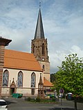
1685 | Evangelical parish church, Kreuzeskirche, single-nave building with rectangular, retracted choir, above neo-Gothic, octagonal stone tower, choir tower 13th century (?), Main building from 1685, rebuilt in 1888/89, renovated in 1921 or 1948/65/66, 16 tombstones in the choir (Rüdt von Collenberg) of the 16th, 17th and 18th centuries. Churchyard with wall and stairs. (Totality).
|
 |
School and town hall | At Römer 4 | 1900 | Former school house, today town hall, two-storey stone gable building with central projection, around 1900.
|
| graveyard | At Romans 16 | Cemetery with enclosure wall, crypt chapel of the Barons Rüdt von Collenberg (house no. 16, floor no. 10002), end of the 19th century (entity with cross)
|
||
 More pictures |
Jewish cemetery Bödigheim | At Romans 31 | 15./16. Century | Jewish association cemetery formerly for up to 30 communities from the area between Eberbach and Boxberg, presumably laid out in the Middle Ages, mortuary timber frame construction with brick infills and flat sloping hipped roof, 1888, in it hearse from 1910 and wooden stretcher (whole).
|
 More pictures |
Tahara house | Am Römer 31 (map) |
Tahara House Bödigheim. Erected in 1888. The Tahara House is part of the Jewish cemetery. The partially half-timbered Tahara house was renovated in 1984. A hearse from 1910 and a wooden bier are still there.
|
|
 More pictures |
Castle complex | Am Schlossberg 1, 2, 2a, 4, 6 (map) |
18th century | Former gardener's house (No. 1), now a residential building, two-story half-timbered building with hipped roof and massive basement, 19th century
Castle park, two-part park (French-English), with gate entrance (wrought-iron grille), fountain and baroque sandstone bench. Wappenstein on the castle park wall, marked 1633 (Rüdt von Collenberg) New castle (No. 4), two-storey central building with three-storey corner pavilions, in the middle the main entrance portal with rusticated pilasters, basket arches and cornice, coat of arms, entrance hall with grave slab and coat of arms, 18th century Pavilion building (No. 2, 2a), two-storey central building, burned out in 1943, rebuilt in 1998, two side wings adjoining at an obtuse angle with hip roof, on the left wing building coat of arms stone from 1777 by Karl Ernst Rüdt von Collenberg and Bödigheim and Magdalena Sophia Carlotta von Berlichingen Rossach Opposite the castle, a baroque gate system with side gates and two little shield houses, inscribed "1770" on the left pillar, wrought-iron gate. On both sides, single-storey farm buildings, enclosing walls, two access bridges and a moat On the western castle wall, the Rüdt-Rieneck double coat of arms Former castle, keep; square humped tower with parapet, shield wall approach and eye notch, 13th / 14th century century Palais, three-storey built-in house with a gable roof and stately renaissance gable, inside wooden beam ceiling, basement still 13th century, eaves side coat of arms stone, inscribed “THIS HAVS IS DURCH ME HANS RVDEN FROM VND ZV BÖDIGHEIM VND COLLENBERGK AND KVNGVNDAY EHLENT GE BORD (?) SFRAW ANNO 1597 STARTED IN THE GRVND ... DVRCH GOD'S BLESSING I (?) 99TH IAR THE ... “. On the northern side of the eaves: the so-called north building, now in ruins, with a Renaissance arched gate on the gable side So-called starch building (No. 6), two-storey solid building with a gable roof, covered patio on the gable side facing the castle garden with sandstone stairs and bathing room below, 18th century On the left side of the eaves the so-called upper gate with screwed profile drapery, inscribed "1606" in the apex Gate system, so-called lower gate, profiled arched gate with adjoining quarry stone wall, inscribed "1600" in the apex (totality).
|
| railway station | Bahnhofweg 1 | Railway station, reception building
|
||
 |
Half-timbered house | Half-timbered house
|
||
 |
relief | Stone relief on house facade.
|
||
 |
relief | Stone relief on house facade.
|
Eberstadt
Architectural, art and cultural monuments in Eberstadt :
![]() Map with all coordinates of the cultural monuments in the district of Eberstadt: OSM
Map with all coordinates of the cultural monuments in the district of Eberstadt: OSM
| image | designation | location | Dating | description |
|---|---|---|---|---|
 More pictures |
Eberstadt Castle | Dorfstrasse 15 (card) |
1380/90, 1755 | The noble family of the Rüdt von Collenberg built the castle as a moated castle around 1380/90, which received its current appearance around 1755.
|
| church | 1717 | The church was built in 1717.
|
Einbach
Architectural, art and cultural monuments in Einbach :
![]() Map with all coordinates of the cultural monuments in the district of Einbach: OSM
Map with all coordinates of the cultural monuments in the district of Einbach: OSM
| image | designation | location | Dating | description |
|---|---|---|---|---|
 |
Council and school house | Elztalstrasse 13 (map) |
1904 | The town's council and school building was built in 1904. The building was used as a council and school building until 1970, and only as a town hall until 1973. After it was incorporated into Buchen, the building was renovated and has been used for various festivities since then.
|
 |
Wayside shrine | Waldhausener Strasse (map) |
Wayside shrine
|
|
| Wayside shrine | Waldhausener Strasse (map) |
Wayside shrine
|
||
 |
Wayside shrine | Waldhausener Strasse (map) |
Wayside shrine
|
Goetzingen
Architectural, art and cultural monuments in Götzingen :
![]() Map with all coordinates of the cultural monuments in the district of Götzingen: OSM
Map with all coordinates of the cultural monuments in the district of Götzingen: OSM
| image | designation | location | Dating | description |
|---|---|---|---|---|
 |
St. Bartholomew | Thingstrasse 24 (map) |
1791 | Catholic parish church St. Bartholomäus, single-nave building from 1791, retracted front tower with portal (and date of construction), polygonal choir, partly rich interior (altars, pulpit etc.) in Neo-Rococo, tower on both sides, and stone crucifix (19th century), east of the nave of Ölberg under neo-Gothic wooden roofing, some old cemetery walls on the north, east and south-east sides; walled grave relief on the north side; two stone urns on the stairs to the cemetery extension (totality).
|
 More pictures |
town hall | (Map) | 1612 | Götzingen town hall is a half-timbered house from 1612.
|
Hainstadt
Architectural, art and cultural monuments in Hainstadt :
![]() Map with all the coordinates of the cultural monuments in the district of Hainstadt: OSM
Map with all the coordinates of the cultural monuments in the district of Hainstadt: OSM
| image | designation | location | Dating | description |
|---|---|---|---|---|
 |
St. Magnus | Kirchenstrasse 13 (map) |
1842 | Catholic Parish Church of St. Magnus; Single-nave building with a single-tower facade and polygonal choir, built in 1842, interior worthy of preservation,
Formerly fortified churchyard with tombstone, outside 1 mission cross, 1 wayside shrine and a stone cross (totality).
|
 |
Chalkboard | Kirchenstrasse 13 | 1750 | Outside of the choir of the parish church of St. Magnus: tablet, red sandstone, lower plinth, column with plinth, base and volute capital, relief tabletop, crowning cross, Holy Family, inscribed on the top "jesus / maria und / josef", around 1750; ZEEK no. 6967-05-011.
|
 |
Stone cross | Kirchenstrasse 13 | 1607 | To the right of the church portal of the parish church of St. Magnus, on the wall, stone cross, 1607, red sandstone, small, Latin cross with round bar ends, the bottom of the cross extends to a roughly larger block that is mostly in the ground, a wreath of ears around a craft mark, bones and skull, inscription (from the old cemetery by the church); ZEEK no. 6967-05-007.
|
 |
Mission cross / crucifixion group | Kirchenstrasse 13 | 1898 | Left in front of the parish church of St. Magnus, on the retaining wall: mission cross, crucifixion group from 1898, red and yellow sandstone, high base with foot and closing element, cross, body, statue, crucifixion scene with Our Lady, Mary Magdalene and John as assistant figures, inscriptions on the trunk of the cross "Save your soul!", On the base "Look there / your mother!" and "See there / your son!" & at the base of the cross; ZEEK no. 6967-05-024.
|
Hettigenbeuern
Architectural, art and cultural monuments in Hettigenbeuern :
![]() Map with all coordinates of the cultural monuments in the district of Hettigenbeuern: OSM
Map with all coordinates of the cultural monuments in the district of Hettigenbeuern: OSM
| image | designation | location | Dating | description |
|---|---|---|---|---|
 |
St. John and Paul | Morretalstrasse 10 (map) |
St. John and Paul
|
|
 |
Half-timbered house | Half-timbered house
|
||
 |
chapel | K 3915, direction Buchen (map) |
chapel
|
Hettingen
Architectural, art and cultural monuments in Hettingen :
![]() Map with all coordinates of the cultural monuments in the district of Hettingen: OSM
Map with all coordinates of the cultural monuments in the district of Hettingen: OSM
| image | designation | location | Dating | description |
|---|---|---|---|---|
| St. Peter u. Paul | (Map) | St. Peter u. Paul
|
||
 |
Chapel in the warrior's grove | (Map) | 1921-1922 | War memorial 1914-18, "Chapel in the warrior grove", 1921/22, plastered masonry, building with a square floor plan with apse, dome roof with onion turret and crowning cross, round arched door, complex with 65 named stone slabs and 65 linden trees and a memorial stone, inscription: ( above the door) D ... GEFALLENEN / 1914–18 (right on the outer wall, red sandstone plaque) DEM / CREATOR / THIS / ANLAGE / HPTL.v. HPTM.DR / EDM. CRUISERS / TO THE MEMORY (memorial stone) Wanderer / look at our home / and tell the brothers / what we are pleased for.
|
| town hall | Römerkastellstrasse 2 (map) |
Town hall. Heimatstube Hettingen: For the Heimatstube the Heimatverein Hettingen has collected old furnishings, handicraft tools, certificates and text documents.
|
||
 |
Ravine chapel | Kapellenweg (map) |
1865/1917 | Chapel. Hohlwegkapelle or Ellwanger Chapel, 1865/1917, plastered masonry, offset with sandstone, wooden gable, brick building with a rectangular floor plan with a gable roof, rectangular door cutout, former shrine as an altar: square base, top of a house with a flat segment arch as a closure, statue of the Virgin Mary, Queen of Heaven, Inscription: (base of the altar) Erected by C. Adam Schönbein / u. his wife M. Anna / b. Falk in the year / 1865 / Rv. v. E. Ellwanger / 1917
|
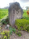
| Way of the Cross | Kapellenweg | 1977-1988 | Fourteen stations of the cross along the old pilgrimage route, today Kapellenweg, between the “hollow chapel” and the “most beautiful Jesus on the meadow” chapel. As part of the celebrations for the tenth anniversary of the Hettingen Heimatverein, the inauguration of the Way of the Cross took place on Sunday, June 18, 1978. The shell limestone came from a quarry in Krensheim near Grünsfeld, while the artistic design was transferred to the Bernhard company from Buchen. The earthworks for the base production began in August 1977 and the first five stations were set up in autumn. Seven more stations followed in March 1978. The last two of the fourteen stations were set up in May 1978.
|
|
 |
1st station of the cross | Kapellenweg | 1977-1988 | Stations of the Cross 01/14: 1st Stations of the Cross made of shell limestone on the fourteen Stations of the Cross on Kapellenweg.
|
 |
2nd station of the cross | Kapellenweg | 1977-1988 | Station of the Cross 02/14: 2nd Station of the Cross made of shell limestone of the fourteen stations of the Cross on Kapellenweg.
|
 |
3rd station of the cross | Kapellenweg | 1977-1988 | Station of the Cross 03/14: 3rd Station of the Cross made of shell limestone of the fourteen stations of the Cross on Kapellenweg.
|
 |
4th station of the cross | Kapellenweg | 1977-1988 | Stations of the Cross 04/14: 4th Stations of the Cross made of shell limestone of the fourteen stations of the Cross on Kapellenweg.
|
 |
5th station of the cross | Kapellenweg | 1977-1988 | Stations of the Cross 05/14: 5th Stations of the Cross made of shell limestone of the fourteen Stations of the Cross on Kapellenweg.
|
 |
6. Stations of the Cross | Kapellenweg | 1977-1988 | Station of the Cross 06/14: 6th station of the cross made of shell limestone of the fourteen stations of the Cross on Kapellenweg.
|
 |
7th station of the cross | Kapellenweg | 1977-1988 | Station of the Cross 07/14: 7th station of the cross made of shell limestone of the fourteen stations of the Cross on Kapellenweg.
|
 |
8. Station of the Cross | Kapellenweg | 1977-1988 | Stations of the Cross 08/14: 8th Stations of the Cross made of shell limestone of the fourteen Stations of the Cross on Kapellenweg.
|
 |
9. Stations of the Cross | Kapellenweg | 1977-1988 | Stations of the Cross 09/14: 9th Stations of the Cross made of shell limestone of the fourteen Stations of the Cross on Kapellenweg.
|
 |
10th station of the cross | Kapellenweg | 1977-1988 | Stations of the Cross 10/14: 10th Stations of the Cross made of shell limestone of the fourteen Stations of the Cross on Kapellenweg.
|
 |
11. Stations of the Cross | Kapellenweg | 1977-1988 | Stations of the Cross 11/14: 11th Stations of the Cross made of shell limestone on the fourteen Stations of the Cross on Kapellenweg.
|
 |
12. Stations of the Cross | Kapellenweg | 1977-1988 | Stations of the Cross 12/14: 12th Stations of the Cross made of shell limestone on the fourteen Stations of the Cross on Kapellenweg.
|
 |
13. Stations of the Cross | Kapellenweg | 1977-1988 | Stations of the Cross 13/14: 13th Stations of the Cross made of shell limestone on the fourteen Stations of the Cross on Kapellenweg.
|
 |
14. Station of the Cross | Kapellenweg | 1977-1988 | Stations of the Cross 14/14: 14th Stations of the Cross made of shell limestone on the fourteen Stations of the Cross on Kapellenweg.
|
| Small fort "An der Altheimer Straße" | Rehberg, Great Forest (map) |
Small fort "An der Altheimer Straße"
|
||
 More pictures |
Small fort Hönehaus | Rehberg, Great Forest (map) |
Small fort Hönehaus
|
Hollerbach
Architectural, art and cultural monuments in Hollerbach :
![]() Map with all the coordinates of the cultural monuments in the district of Hollerbach: OSM
Map with all the coordinates of the cultural monuments in the district of Hollerbach: OSM
| image | designation | location | Dating | description |
|---|---|---|---|---|
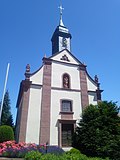 |
St. John the Baptist | Holunderstraße 1 (map) |
1781-83, crypt from previous building from the 12th century | St. John the Baptist
|
 |
Council and school house | Council and school house
|
||
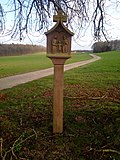 |
Wayside shrine | Wayside shrine
|
Oberneudorf
Architectural, art and cultural monuments in Oberneudorf :
![]() Map with all coordinates of the cultural monuments in the district of Oberneudorf: OSM
Map with all coordinates of the cultural monuments in the district of Oberneudorf: OSM
| image | designation | location | Dating | description |
|---|---|---|---|---|
 |
chapel | Wendelin-Scheuermann-Str. 20 (card) |
1906/1963 | In 1906 a small chapel was built, which was expanded in 1963.
|
 |
crossroads | To the Prinzenstein (map) |
crossroads
|
Rinschheim
Architectural, art and cultural monuments in Rinschheim :
![]() Map with all coordinates of the cultural monuments in the district of Rinschheim: OSM
Map with all coordinates of the cultural monuments in the district of Rinschheim: OSM
| image | designation | location | Dating | description |
|---|---|---|---|---|
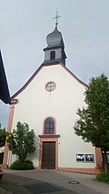 |
St. Hippolytus and Kassian | Raiffeisenstrasse 1 (map) |
Church of St. Hippolyt and Kassian
|
|
 |
crossroads | Raiffeisenstrasse 1 (near) (map) |
crossroads
|
|
| Small fort Rinschheim | (Map) | Small fort Rinschheim
|
Stürzenhardt
Architectural, art and cultural monuments in Stürzenhardt :
![]() Map with all coordinates of the cultural monuments in the district of Stürzenhardt: OSM
Map with all coordinates of the cultural monuments in the district of Stürzenhardt: OSM
| image | designation | location | Dating | description |
|---|---|---|---|---|
 |
Wayside shrine | K 3916 (card) |
Wayside shrine
|
|
 |
Wayside shrine | K 3916 (card) |
Wayside shrine
|
|
 |
Wayside shrine | K 3916 (card) |
Wayside shrine
|
|
| Wayside shrine | K 3916 (card) |
Wayside shrine
|
||
 |
Wayside shrine | K 3916 (card) |
Wayside shrine
|
|
 |
St. Isidore | Odenwaldhöhe 3 (map) |
1795 | Branch chapel St. Isidor, built in 1795.
|
Untereudorf
Architectural, art and cultural monuments in Untereudorf :
![]() Map with all the coordinates of the cultural monuments in the subdivision of Untereudorf: OSM
Map with all the coordinates of the cultural monuments in the subdivision of Untereudorf: OSM
| image | designation | location | Dating | description |
|---|---|---|---|---|
 |
Holy Blood Wayside Shrine | Ortsstrasse 8 (map) |
Holy blood wayside shrine about the blood miracle of Walldürn
|
|
 |
St. George | Untere Ortsstrasse 1 (map) |
1699 | Catholic branch church St. Georg, 1699.
|
Waldhausen
Architectural, artistic and cultural monuments in Waldhausen :
![]() Map with all coordinates of the cultural monuments in the district of Waldhausen: OSM
Map with all coordinates of the cultural monuments in the district of Waldhausen: OSM
| image | designation | location | Dating | description |
|---|---|---|---|---|
 |
crossroads | Am Römer (map) |
crossroads
|
|
 |
Wayside shrine | Am Römer (map) |
Wayside shrine
|
|
 |
St. Michael | Bödigheimer Weg 6 (map) |
1902-1904 | Parish Church of St. Michael, built in the neo-baroque style between 1902 and 1904, is one of the most beautiful country churches in the southeastern Odenwald.
|
 |
Cemetery chapel | Bödigheimer Weg (map) |
Cemetery chapel
|
Web links
Individual evidence
- ↑ LEO-BW.de: Building (Abt-Bessel-Straße 7, Buchen (Odenwald))
- ↑ bawue.museum-digital.de, Amtshaus in Buchen
- ↑ LEO-BW.de: Bahnhof (Eisenbahnstraße 4, Buchen (Odenwald)) .
- ↑ https://www.leo-bw.de/web/guest/detail-gis/-/Detail/details/DOKUMENT/lad_denkmale/100069746/Ehemalige+Kelter+Haagstra%C3%9Fe+10+Buchen+Odenwald
- ^ Regional council Karlsruhe (ed.): Directory of immovable architectural and art monuments in Baden-Württemberg. Neckar-Odenwald district. Beeches (Odenwald). As of April 27, 2010, p. 18.
- ^ Regional council Karlsruhe (ed.): Directory of immovable architectural and art monuments in Baden-Württemberg. Neckar-Odenwald district. Beeches (Odenwald). As of April 27, 2010, p. 20.
- ↑ LEO-BW.de: Besselkapelle (Walldürner Straße 16, Buchen (Odenwald)) .
- ↑ LEO-BW.de: Former teacher's house (Wimpinaplatz 4, Buchen (Odenwald))
- ↑ LEO-BW.de: Wimpinahaus (Wimpinaplatz 5, Buchen (Odenwald))
- ^ Regional council Karlsruhe (ed.): Directory of immovable architectural and art monuments in Baden-Württemberg. Neckar-Odenwald district. Beeches (Odenwald). As of April 27, 2010, p. 22.
- ↑ Kath-Buchen.de: St. Bartholomäus . Online at www.kath-buchen.de. Retrieved December 18, 2019.
- ↑ Kath-Buchen.de: St. Magnus . Online at www.kath-buchen.de. Retrieved December 18, 2019.
- ↑ Kath-Buchen.de: St. John and Paul . Online at www.kath-buchen.de Retrieved December 18, 2019.
- ↑ Kath-Buchen.de: St. Peter and Paul . Online at www.kath-buchen.de. Retrieved December 18, 2019.
- ↑ a b c d e f g h i j k l m n o Fränkische Nachrichten: Hettinger Kreuzweg. Inauguration took place years ago. Project was controversial. Great achievement of the home club. Way of the Cross a sign of faith . June 18, 2018. Online at www.fnweb.de. Retrieved April 25, 2019.
- ↑ a b c d e f g h i j k l m n o Heimatverein Hettingen: Chronicle . Online at www.heimatverein-hettingen.de. Retrieved April 25, 2019.
- ↑ Kath-Buchen.de: St. John the Baptist . Online at www.kath-buchen.de. Retrieved December 18, 2019.
- ↑ Kath-Buchen.de: St. Hippolytus and Cassiano . Online at www.kath-buchen.de. Retrieved December 18, 2019.
- ↑ LEO-BW.de: Catholic Church St. Georg (Untere Ortsstrasse 1, Buchen (Odenwald)) . Online at www.leo-bw.de. Retrieved March 30, 2019.
- ↑ Kath-Buchen.de: St. Michael . Online at www.kath-buchen.de. Retrieved December 18, 2019.
Remarks
- ↑ This list may not correspond to the current status of the official list of monuments. This can be viewed by the responsible authorities. Therefore, the presence or absence of a structure or ensemble on this list does not guarantee that it is or is not a registered monument at the present time. The State Office for Monument Preservation Baden-Württemberg provides binding information .