Maasdorf (Bad Liebenwerda)
|
Maasdorf
City of Bad Liebenwerda
Coordinates: 51 ° 32 ′ 6 " N , 13 ° 24 ′ 30" E
|
|
|---|---|
| Height : | 90 m |
| Residents : | 502 (December 31, 2016) |
| Incorporation : | December 6, 1993 |
| Postal code : | 04924 |
| Area code : | 035341 |
|
Location of Maasdorf in Bad Liebenwerda
|
|
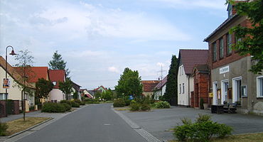
Maasdorf is a district of the city of Bad Liebenwerda in the Elbe-Elster district in Brandenburg and is located three kilometers northeast of the city on the Kleine Elster in the Niederlausitzer Heidelandschaft nature park .
Maasdorf was part of the Bad Liebenwerda district until it was incorporated in 1993 and currently has 464 inhabitants.
history
The first documentary mention in 1376 referred to the place as Mostorph . There are no specific records about the origin of the name in writing. It is probably of German origin. But over the centuries there were a number of different spellings: 1376 Mostorph , 1378 Mostorf , 1391 Mannstorf , 1402 Mansdorff , 1442 Mastorff , 1457 Monstorff , 1529 Maßdorff , 1550 Masdorff , 1752 Maasdorff .
The original owner of the village was the noble family of the Ileburger , who at that time ruled the castle in Liebenwerda and belonged to the Upper Saxon nobility . If justice was to be spoken, the Maasdorfer had to appear in front of the Dingstuhl in Dobra, to which, in addition to Dobra and Maasdorf, the Liebenwerda suburbs Stadtwinkel and Freiwinkel, Zeischa and Zobersdorf belonged. The residents suffered greatly from the floods of the Kleiner Elster (formerly Dober ) a tributary of the Black Elster . Therefore, a dam 122.5 cubits in length was built on the river in 1789 to protect the village from flooding.
Like most places, Maasdorf was not spared from major fires. And so the village was completely destroyed in a devastating fire in 1457. During the subsequent reconstruction of the village, the residents received support from the parish of Wahrenbrück , which Maasdorf was a part of at that time. Since the village did not have its own church, people went to worship in Wahrenbrück and the deceased residents were buried there. The name “ Leichenweg ” has therefore been retained for a path leading from Maasdorf to Wahrenbrück up to the present day . After the first church visit in 1529, Maasdorf was separated from Wahrenbrück and from then on the village belonged to the Parish Liebenwerda. Other major fires occurred in February 1609 when the fire killed 17 houses and in January 1856 when six farms were destroyed. In 1874 a volunteer fire brigade was finally founded in the village. According to the Liebenwerdaer Kreisblatt, the fire engines were subjected to an initial inspection on Friday, July 23, 1875 at 3:30 p.m.
From 1875 the Knissen colony belonged to Maasdorf. But already in 1936 it was incorporated into Thalberg, which was given a district area again through the assignment of the fields belonging to the settlement and became an independent municipality.
Shortly before the end of the Second World War, the Red Army moved into Maasdorf on April 22, 1945 . The Russian soldiers searched all yards mainly for horses, of which the best were confiscated. A plot of land where a broken down military vehicle was found was burned down by the soldiers. After the official end of the war, on May 11, 1945, the village school teacher Karl Drechsler was shot in front of his wife during an argument with Russian soldiers in the school garden.
Land reform began in the Bad Liebenwerda district as early as autumn 1945 . In accordance with the Land Reform Ordinance (BRVO), private and state property over 100 hectares with all buildings, living and dead inventory and other agricultural property were expropriated and divided. By March 1 of the following year, a total of 9580 hectares had been expropriated and distributed in the district. In Maasdorf this affected the manor owner Paul Weiland. 157 hectares of land have been divided here.
In the German Democratic Republic founded in October 1949 , Maasdorf initially belonged to the state of Saxony-Anhalt, which was dissolved in 1952 . After the districts were founded , the village belonged to the Cottbus district until the reunification of the two German states in 1990 .
Maasdorf belonged to the district of Bad Liebenwerda until the district reform in Brandenburg in 1993 , which was incorporated into the district of Elbe-Elster on December 6, 1993 with the districts of Herzberg and Finsterwalde . On the same day, the community was incorporated into the city of Bad Liebenwerda together with the towns of Dobra , Kosilenzien , Kröbeln , Lausitz , Möglenz , Neuburxdorf , Oschätze , Prieschka , Thalberg , Theisa , Zeischa and Zobersdorf .
Population development
- In 1835 Maasdorf owned 43 houses with 211 inhabitants, 44 horses, 196 cattle, 425 sheep, 13 goats and 98 pigs.
| Population development in Maasdorf since 1875 | |||||||||||||
|---|---|---|---|---|---|---|---|---|---|---|---|---|---|
| year | Residents | year | Residents | year | Residents | ||||||||
| 1875 | 500 | 1946 | 623 | 1989 | 522 | ||||||||
| 1890 | 600 | 1950 | 641 | 1990 | 510 | ||||||||
| 1910 | 700 | 1964 | 556 | 1991 | 491 | ||||||||
| 1925 | 837 | 1971 | 546 | 1992 | 494 | ||||||||
| 1933 | 922 | 1981 | 535 | 2005 | 477 | ||||||||
| 1939 | 982 | 1985 | 525 | 2010 | 444 | ||||||||
Culture and sights
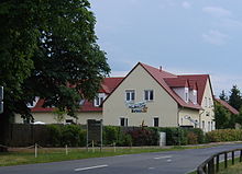
One of the sights is the manor Maasdorf, the so-called "Parkschlösschen", on the Mühlgraben. The former domain was mentioned as early as 1701. At that time it belonged to the chief forester von Seydewitz . In 1898 it was sold to Paul Weiland. His wife, who comes from South Tyrol , had the individual buildings connected with one another in the Italian style with turrets, which gave the new building a castle-like character. The manor remained in the possession of the Weiland family until the land reform in Germany. In 1984 a restaurant was finally set up in the building. At present, the Parkschlösschen restaurant and hotel are located here.
Another tourist attraction is the Maasdorfer Elster-Natoureum, inaugurated in 2005. “See nature, experience it and learn from it” is the motto of the facility, where the region of the Elbe-Elster-Land with its sights is presented in miniature format. In the outdoor facilities there is also a 320-meter - long LGB garden tramway with a track width of 45 millimeters.
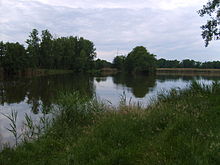
Not far from the village, near the former Maasdorf district of Knissen, there are the “ Maasdorf ponds ”. They were built for fish farming in 1543 and are now a popular destination.
In the Maasdorf cemetery there is a war memorial in the form of a stele, which is intended to commemorate the thirty-four Maasdorf residents who died in the First World War and forty in the Second World War .
Personalities
- The cyclist Axel Peschel , born in Maasdorf in 1942 , won the 1968 International Peace Ride in Warsaw, which was very popular at the time .
Footnotes and individual references
- ↑ Community and district directory of the state of Brandenburg. Land surveying and geographic base information Brandenburg (LGB), accessed on June 22, 2020.
- ↑ December 31, 2005.
- ^ Home calendar for the Bad Liebenwerda district. 1959, p. 28.
- ↑ a b c d e f g Christine Bestek: Maasdorf district . In: Association for city marketing and economy Bad Liebenwerda eV (Hrsg.): Chronicle of the city of Liebenwerda . Winklerdruck Gräfenhainichen, Bad Liebenwerda 2007, ISBN 978-3-7245-1420-6 , p. 258/259 .
- ^ M. Karl Fitzkow : From the Dingstuhl to the District Court . In: Home calendar for the Bad Liebenwerda district . Print shop activist Bad Liebenwerda, Bad Liebenwerda 1962, p. 136-146 .
- ↑ Herbert Bartha: District Dobra . In: Association for city marketing and economy Bad Liebenwerda eV (Hrsg.): Chronicle of the city of Liebenwerda . Winklerdruck Gräfenhainichen, Bad Liebenwerda 2007, ISBN 978-3-7245-1420-6 , p. 248/249 .
- ↑ a b “From the municipality book of the village of Maasdorff” in “Die Schwarze Elster”, No. 361, 1928.
- ^ A b Waldemar Schmidt: District Thalberg . In: Association for city marketing and economy Bad Liebenwerda eV (Hrsg.): Chronicle of the city of Liebenwerda . Winklerdruck Gräfenhainichen, Bad Liebenwerda 2007, ISBN 978-3-7245-1420-6 , p. 268/269 .
- ↑ Jürgen Bartholomäus : The death of the teacher Karl. D. In: Home calendar for the Bad Liebenwerda district and the Mückenberger Ländchen. 1995, pp. 95-100.
- ↑ Torsten Lehmann: The implementation of the land reform in the old district of Liebenwerda . In: Arbeitsgemeinschaft für Heimatkunde e. V. Bad Liebenwerda (Ed.): Local calendar for the old district of Bad Liebenwerda, the Mückenberger Ländchen, outskirts on Schraden and Uebigau-Falkenberg . Bad Liebenwerda 1997, p. 101 .
- ↑ a b Fritz Wilhelm: You fought for better Germany records on the anti-fascist resistance struggle in the Liebenwerda district . S. 123 .
- ↑ a b Historical municipality directory 2005 for Brandenburg ( online as PDF file ), accessed on September 26, 2010.
- ^ Changes in the municipalities of Germany, see 1993 StBA
- ↑ Overview of the population and the number of livestock in 1835 . In: Die Schwarze Elster-Our home in words and pictures . No. 596 . Bad Liebenwerda 1985, p. 8 to 10 .
- ↑ a b The population of the city of Bad Liebenwerda and its districts since 1835. ( Memento of the original dated November 30, 2012 in the Internet Archive ) Info: The archive link was inserted automatically and has not yet been checked. Please check the original and archive link according to the instructions and then remove this notice. on the homepage of the city of Bad Liebenwerda. (Online as PDF file; 48 kB), accessed on April 13, 2011.
- ↑ Parkschlößchen Maasdorf ( Memento from August 2, 2012 in the web archive archive.today )
- ↑ The Elster-Natoureum on the Maasdorf homepage , accessed on April 12, 2011.
- ↑ Chronicle of the City of Liebenwerda, 2007, pp. 258/259.
- ↑ Online project Memorial Monuments , accessed on April 12, 2011.
Web links
- Community homepage
- Maasdorf in the RBB program Landschleicher on November 25, 2012


