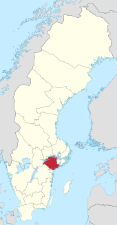
Södermanland County
| Södermanland County | |
|---|---|

|
|
| Basic data | |
| Historical Province ( landskap ) : | Södermanland |
| Residence town (residensstad) : | Nykoping |
| Administrative structure: | 9 municipalities |
| District President ( landshövding ) : | Liselott Hagberg |
| Letter (länsbokstav) : | D. |
| SCB code: | 04 |
| Residents : | 297,540 (December 31, 2019) |
| Area : | 7,026.1 km² |
| Population density : | 42.3 inhabitants / km² |
| Establishment (year): | 1634 |
| Website: | www.d.lst.se |
Coordinates: 59 ° 0 ' N , 16 ° 48' E
Södermanlands län is a province ( län ) in Sweden .
geography
Södermanlands län is formed from the southern area of the historical province (landskap) Södermanland , which includes the eastern part of the central Swedish region of Svealand .
The territory of Södermanland County accounts for about 1.6% of the area of the Swedish national territory.
population
It accounts for 2.9% of the total population of Sweden.
Parishes and places
Södermanland County consists of nine municipalities .
Communities
| local community | Residents |
|---|---|
| Eskilstuna | 106,859 |
| Flen | 16,585 |
| Gnesta | 11,365 |
| Katrineholm | 34,755 |
| Nykoping | 56,591 |
| Oxelösund | 11,983 |
| Strängnäs | 36,544 |
| Trosa | 13,747 |
| Vingåker | 9.111 |
(As of December 31, 2019)
Biggest places
- Eskilstuna (64,679)
- Nykoping (29,891)
- Katrineholm (21,993)
- Strängnäs (12,856)
- Oxelösund (10,870)
(Residents as of December 31, 2010)
Attractions
- Nyköpingshus Castle with Sörmlands museum
- Strängnäs Cathedral
- Åsa burial ground
- Gripsholm Castle
- Nynäs Castle
- Sundbyholm Castle
- Sörmlandsleden hiking trail network
For more prehistoric monuments and rune stones see category: Archaeological site in Södermanland County .
Web links
Commons : Södermanlands län - Collection of images, videos and audio files
swell
- ↑ a b Folkmängd i riket, län och kommuner December 31, 2019 at Statistiska centralbyrån
- ↑ Kommunarealer January 1, 2016 at Statistiska centralbyrån (including all inland waters)


