
Manou
| Manou | ||
|---|---|---|
|
||
| region | Center-Val de Loire | |
| Department | Eure-et-Loir | |
| Arrondissement | Nogent-le-Rotrou | |
| Canton | Nogent-le-Rotrou | |
| Community association | Terres de Perche | |
| Coordinates | 48 ° 31 ' N , 0 ° 59' E | |
| height | 194-277 m | |
| surface | 13.38 km 2 | |
| Residents | 597 (January 1, 2017) | |
| Population density | 45 inhabitants / km 2 | |
| Post Code | 28240 | |
| INSEE code | 28232 | |
 Manou Town Hall (Mairie) |
||

Manou is a French municipality with 597 inhabitants (as of January 1 2017) in the department of Eure-et-Loir in the region Center-Val de Loire ; it belongs to the arrondissement of Nogent-le-Rotrou and the canton of Nogent-le-Rotrou (until 2015: canton of La Loupe ).
geography
Manou is about 40 kilometers west-northwest of Chartres on the Eure . Manou is surrounded by the neighboring communities of Senonches in the north and east, Fontaine-Simon in the south and south-east, Les Menus in the west and south-west, Neuilly-sur-Eure in the west and La Ferté-Vidame in the north-west.
Population development
| year | 1962 | 1968 | 1975 | 1982 | 1990 | 1999 | 2006 | 2013 |
| Residents | 440 | 392 | 461 | 474 | 433 | 511 | 545 | 577 |
| Source: Cassini and INSEE | ||||||||
Attractions
- Saint-Pierre church
- Chapel of Sainte-Anne
- Manou Castle
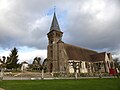
Saint-Pierre church

Entrance to Manou Castle


Community partnerships
There is a partnership with the Canadian municipality of Petit-Saguenay in the province of Québec.
Web links
Commons : Manou - collection of images, videos and audio files