
Montireau
| Montireau | ||
|---|---|---|
|
||
| region | Center-Val de Loire | |
| Department | Eure-et-Loir | |
| Arrondissement | Nogent-le-Rotrou | |
| Canton | Nogent-le-Rotrou | |
| Community association | Terres de Perche | |
| Coordinates | 48 ° 25 ' N , 1 ° 2' E | |
| height | 217-282 m | |
| surface | 10.1 km 2 | |
| Residents | 140 (January 1, 2017) | |
| Population density | 14 inhabitants / km 2 | |
| Post Code | 28240 | |
| INSEE code | 28264 | |

Montireau is a French municipality with 140 inhabitants (as of January 1 2017) in the department of Eure-et-Loir in the region Center-Val de Loire ; it belongs to the arrondissement of Nogent-le-Rotrou and the canton of Nogent-le-Rotrou (until 2015: canton of La Loupe ).
geography
Montireau located about 38 km west-southwest of Chartres . Montireau is surrounded by the neighboring communities of Saint-Éliph in the north, Champrond-en-Gâtine in the east and southeast, Montlandon in the south and Saint-Victor-de-Buthon in the west.
Population development
| year | 1962 | 1968 | 1975 | 1982 | 1990 | 1999 | 2006 | 2013 |
| Residents | 117 | 128 | 109 | 110 | 138 | 106 | 115 | 145 |
| Source: Cassini and INSEE | ||||||||
Attractions
- Saint-Barthélemy church from the 16th century, monument historique since 1980
- Montireau Castle

Saint Barthélemy Church
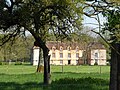
Montirea Castle


Web links
Commons : Montireau - collection of images, videos and audio files