
Les Etilleux
| Les Etilleux | ||
|---|---|---|
|
||
| region | Center-Val de Loire | |
| Department | Eure-et-Loir | |
| Arrondissement | Nogent-le-Rotrou | |
| Canton | Brou | |
| Community association | Perche | |
| Coordinates | 48 ° 14 ' N , 0 ° 49' E | |
| height | 162-265 m | |
| surface | 8.35 km 2 | |
| Residents | 221 (January 1, 2017) | |
| Population density | 26 inhabitants / km 2 | |
| Post Code | 28330 | |
| INSEE code | 28144 | |

Les Étilleux is a French municipality with 221 inhabitants (as of January 1 2017) in the department of Eure-et-Loir in the region Center-Val de Loire ; it belongs to the arrondissement Nogent-le-Rotrou and the canton Brou (until 2015: canton Authon-du-Perche ).
geography
Les Étilleux is located about 55 kilometers west-southwest of Chartres in the Perche . Les Étilleux is surrounded by the neighboring communities of Souancé-au-Perche in the north and north-east, Coudray-au-Perche in the east and south-east, Saint-Bomer in the south, Ceton in the west and south-west and Mâle in the north-west.
Population development
| year | 1962 | 1968 | 1975 | 1982 | 1990 | 1999 | 2006 | 2013 |
| Residents | 247 | 233 | 200 | 168 | 184 | 188 | 188 | 233 |
| Source: Cassini and INSEE | ||||||||
Attractions
- Notre-Dame church from 1214, monument historique since 2003
- Le Grand Fresnay Castle, built in 1480, has been a monument historique since 1978
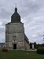
Notre-Dame church
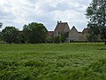
Le Grand Fresnay Castle


Web links
Commons : Les Étilleux - Collection of images, videos and audio files