
Golfe du Lion marine nature park


The marine nature park Golfe du Lion ( French: Parc naturel marin du golfe du Lion ) is located in the bay of the same name, Golfe du Lion, on the French Mediterranean coast . The coastal strip located in the departments of Pyrenees-Orientales and Aude in the region Okzitanien and is one of twelve coastal communes . The marine nature park includes the rocky coastline of the Côte Vermeille and ends at the border with Spain . It is home to around 1200 animal and 500 plant species.
Park management
The marine nature park was founded on October 11, 2011. The park administration is based in Port-Vendres ( 42 ° 31 ′ 8 ″ N , 3 ° 6 ′ 21 ″ E, ). The nature park covers a sea area of 4,019 km² and a coastline of around 100 kilometers.
Affiliated municipalities
On the land side, the park borders on the following municipalities (from north to south):

Cap Leucate
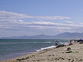
Canet-en-Roussillon beach, looking south

Argelès-sur-Mer, looking north

Collioure

Banyuls-sur-Mer
,_naval_radar_station.jpg)

.JPG)


Landscapes
Coastal areas
The landscape between the eastern Pyrenees and the Mediterranean has an exceptionally rich landscape diversity, especially thanks to its high-contrast relief. There are two different zones:
- The Roussillon plain
This is a fertile, by the rivers Tet , Agly , Tech irrigated and its tributaries alluvial in particular fruit and vegetable production are operated. The coastal area of this plain is formed by a wide sandy beach , which on its land side still has a number of lakes and ponds (e.g. Étang de Leucate , Étang de Canet ), where freshwater and seawater mix. This high-contrast environment is favorable for great ecological diversity and protects special plant and animal species, such as B. the little bittern , the purple heron or the blue roller . The lagoon lakes are also places for reproduction , spawning and growth of numerous species of marine fish.

Saint-Cyprien sandy beach

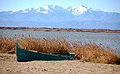
Lagoon lake Étang de Leucate
Etang-de-Canet lagoon lake

Wolf spider at the Etang de Canet

Purple heron


-02.JPG)

- The Albères massif
This foothill of the Pyrenees is dominated by crystalline rock formations . In the foreground are the steep rock cliffs formed from shale , which slope in a straight line to the coastline. Small bays form between them that are either still natural or in which harbors have already been set up. This cliff is also known as the Côte Vermeille . In the altitude above the steep drop, the landscape is characterized by small hamlets and artificially constructed terraces , where viticulture is practiced and cork oaks and holm oaks are also cultivated.

Cap Béar at Port-Vendres
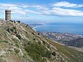
Tour Madeloc, municipality of Collioure

Panorama of the Côte Vermeille

Cork oak

The cliffs at Cerbère

.JPG)


- Climate and vegetation on the coast
The coastal area's climate is characterized by warm and dry summers and generally mild winters. Throughout the year the Tramontana wind occurs occasionally , the violence of which surprises and makes Cap Béar one of the stormiest places in Europe. The vegetation corresponds to these climatic peculiarities: in addition to the usual southern flora, which finds ideal conditions for it to thrive, also such species develop here that are otherwise only encountered on the coasts of Africa or in Central America, such as. B. the orange tree , the lemon tree , the prickly pear , the pomegranate , various types of palm , mimosa , etc.
Marine areas

The water surface extends at right angles from the coast around 30 to 35 nautical miles into the open sea and thus clearly exceeds the territorial sea , which is limited to twelve nautical miles and which is defined as national territorial waters according to the international law of the sea . Outside this zone, state powers are gradually decreasing.
In this area there is an abundance of flora and fauna worthy of protection, such as B.
- the neptune grass ,
- the precious corals ,
- the noble pen shell ,
- the diadem sea urchin ,
- the bear cancer
- the brown grouper ,
- the loggerhead turtle
- as well as more than 20 species of whales , including the fin whale and bottlenose dolphin .

A very interesting marine biotope is also represented by three submarine canyons , which are up to 1,200 meters deep and therefore accommodate very special populations. They are:
- Canyon Lacaze-Duthiers (up to 1,000 m)
- Canyon Pruvot (up to 1,000 m)
- Canyon Bourcart (up to 1,200 m)