
Milešovka
| Milešovka | ||
|---|---|---|
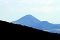
 Milešovka seen from the south |
||
| height | 836.6 m nm | |
| location | Ústecký kraj , Czech Republic | |
| Mountains | Central Bohemian Uplands | |
| Dominance | 20.3 km → Stropník | |
| Coordinates | 50 ° 33 '18 " N , 13 ° 55' 54" E | |
|
||
| Type | Kegelberg | |
| rock | Phonolite | |
| Development | Construction of the Donnersbergwarte in 1904 | |
| particularities | Highest mountain in the Bohemian Central Uplands | |

The Milešovka (German Milleschauer , also Donnersberg ) is at 836 meters the highest mountain in the Bohemian Central Uplands in the Czech Republic . In today's Czech usage it is also referred to as "Královna Českého středohoří" ( Queen of the Bohemian Central Uplands ). The near-natural deciduous forests on the 30 ° steep south side are remarkable. The forest-free rocky areas, in which many rare plants can be found, are valuable from a biological point of view. Since 1951, the 51.3 hectare mountain has been protected as a national nature reserve.
Location and surroundings
The Milešovka is centrally located in the western part of the Bohemian Uplands, about 15 km south of Teplice ( Teplitz ) and Ústí nad Labem ( Aussig ). At its foot are the places Milešov ( Milleschau ), Černčice ( Tschentschitz ) and Bílka ( Pilkau ).
history
The mountain began to attract visitors as early as the early 19th century. Between 1819 and 1839 the Prussian King Friedrich Wilhelm III hiked . the mountain regularly. His companion, the world traveler and naturalist Alexander von Humboldt , described the view from the Milleschauer as the third most beautiful in the world. Even then there was a first mountain inn, which is one of the oldest in Bohemia.
In 1904, after just one year of construction, the Donnersbergwarte was inaugurated as a meteorological station; the weather observations , which have been carried out continuously to this day , began on January 1, 1905. The place was chosen because of the clean atmosphere and initiated, among others, by Reginald Czermack , an important fire service manufacturer and pioneer for Austria. The first director of the observatory was the Carinthian university professor Rudolf Spitaler .
From then on, the tower of the building also served as an observation tower. During the Second World War , the buildings on the mountain were also used for military purposes, and the observation tower was no longer accessible. After 1945, Charles University in Prague took over the meteorological station, and the mountain inn was still in use until the 1960s. Radio link systems (also for television broadcasts) later found space in the former inn. In the 1990s there were considerations to rebuild a mountain inn; For reasons of nature conservation, this was initially omitted. There is now a snack. The tower has been accessible again on weekends since the mid-1990s.
Archaeologists have also struck gold on the mountain. Numerous ceramic remains from the early Stone Age indicate an early settlement.
geology
The mountain consists of phonolite ( Klingstein ), or more precisely of sodalithic trachyte .
view
The view from the Milešovka offers an overview of almost the entire North Bohemian landscape on a clear day. In the north there is the wall of the Ore Mountains with Bouřňák ( striker ) and Komáří vížka ( mosquito turret ), further east - already in Bohemian Switzerland - the Děčínský Sněžník ( High Snow Mountain ). Even further to the east is the jagged chain of the Lusatian Mountains , which then merges into the Jeschkenkamm with the Ještěd ( Jeschken ). The foreground is dominated by Kletečná ( Kletschen ), Varhošť ( Aarhorst ), Sedlo ( Hoher Geltsch ), Lovoš ( Lobosch ) and the other mountains of the Bohemian Central Uplands. Far to the east, the ridge of the Jizera and Giant Mountains can be seen in the distance . In the south, already in the Egern lowlands , you can see the Hazmburk ( Hasenburg ) - the symbol of the Bohemian Uplands. Behind it, the mountain ranges of the Džbán ( Krugwald ) limit the horizon. In the west, the Hradišťany ( Radelstein ) massif dominates the picture, and the towers of Kostomlaty Castle ( Kostenblatt ) are clearly visible. Behind it, your gaze wanders over the wide basin near Chomutov ( Komotau ) and Most ( Brüx ), bounded by the mass of the Duppau Mountains .
The observation tower is open all year round (status: information from the cashier May 2018). Entry CZK 30, reduced CZK 20.
Routes to the summit
- You can get to Milešovka from Ústí via the main hiking route marked in red. The ascent to the summit (about an hour) begins in Bílka .
- The mountain can also be hiked along the route of the former bowling path from Velemín .
- The community of Milešov is also a good starting point; the slightly elevated castle there is worth seeing.
- The shortest ascent leads from the small town of Černčice via a blue route to the summit.
gallery

View from Milešovka to the south, in the foreground Milešov
Milešovka from Dlouhá Louka in the Ore Mountains
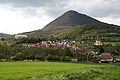
View of Milešov with Milešovka

Milešovka on a painting by Caspar David Friedrich
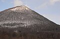
The mill shower in winter

Milešovka with a cloud fringe in January


literature
- On the highest mountain of the Bohemian Central Uplands - the Milleschauer. In: Peter Rölke (Hrsg.): Wander- & Naturführer Böhmisches Mittelgebirge , Berg- & Naturverlag Rölke, Dresden 2008, ISBN 978-3-934514-22-5 , pp. 84-101.
Individual evidence
- ^ History of the observatory. January 30, 2012, archived from the original on October 15, 2008 ; accessed on April 26, 2016 (English).
Web links
- Milešovka Meteorological Station. ufa.cas.cz, archived from the original on June 17, 2012 ; Retrieved April 26, 2016 (Czech).
- Photo gallery