Millstadt (Illinois)
| Millstadt | ||
|---|---|---|
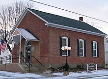
 Millstadt Community Center |
||
| Location in Illinois | ||
|
|
||
| Basic data | ||
| Foundation : | 1837 | |
| State : | United States | |
| State : | Illinois | |
| County : | St. Clair County | |
| Coordinates : | 38 ° 28 ′ N , 90 ° 6 ′ W | |
| Time zone : | Central ( UTC − 6 / −5 ) | |
| Residents : | 3,247 (as of: estimate from July 2006) | |
| Population density : | 1,119.7 inhabitants per km 2 | |
| Area : | 2.9 km 2 (approx. 1 mi 2 ) of which 2.9 km 2 (approx. 1 mi 2 ) are land |
|
| Height : | 188 m | |
| Postcodes : | 62220-62260 | |
| Area code : | +1 618 | |
| FIPS : | 17-49386 | |
| GNIS ID : | 426434 | |
| Website : | www.villageofmillstadt.org | |
| Mayor : | Mike Todd | |
Millstadt is a municipality ( village ) in St. Clair County in Illinois in the United States . It is located at the southern end of Illinois Route 163, which intersects with Illinois Route 158 here. The city is located in the eastern part of the Greater St. Louis metropolitan region called Metro-East , around 6 km northwest of the city of St. Louis in neighboring Missouri .
At the time of the 2000 United States Census , there were 2,794 people living here, but a recent study in July 2006 estimated the population to be 3,247.
geography
According to the United States Census Bureau , Millstadt has an area of 2.9 km² .
Urban area
The structure of the city center is formed by the intersection of two state highways . Illinois State Route 158 , or Washington Avenue, runs to Columbia on the west and Belleville on the east . The other main street is Jefferson Avenue, the northern portion of which forms the southern end of Illinois State Route 163 . This leads north to Centerville , where it crosses highways on which one can reach St. Louis . The southern end of Jefferson Avenue is then called Floraville Road outside of Millstadt.
history
During a joint barn building in 1836, it was proposed that a town be founded on Henry Randleman’s estate. It should be called Centerville because it is equidistant from Belleville , Columbia , and Pittsburg Lake. On March 13, 1837 a land map ( plat ) was created. In 1880 the name was changed to Millstadt, as the name Centerville was already used by another town nearby.
Another version (from the Millstadt school homepage): “The story of how Centerville became Millstadt was something like this: The present Centerville and our Centerville each had a post office, in which a large amount of mail got mixed up and was delivered incorrectly. Our ancestors applied for official state organization. They had decided to use the name "Mittlestadt" or "Middlestadt", which literally means "center city". Somehow the letter was misinterpreted and the files were sent back with "Millstadt". As you can imagine, the government group decided to keep this name because we had several mills at the time and the name was a fitting. "
See also
Demographics
At the time of the 2000 United States Census, Millstadt had 2794 people, 1148 households, and 813 resident families in the parish. The population density was 971.9 people per km ². There were 1196 housing units at an average of 416.0 per km².
The Millstadt population was 98.68% White , 0.25% Native American , 0.25% Asian , 0.29% other races, and 0.54% named two or more races. 0.75% of the population declared to be Hispanic or Latino of any race.
There were 1,148 households out of which 31.8% had children under the age of 18, 59.1% were married couples living together, 8.9% had a female householder without a husband, and 29.1% were non-families. 25.3% of households were made up of individuals and someone lived in 12.5% of all households aged 65 years or older. The average household size was 2.43 and the average family size was 2.92.
The population was divided into 23.7% minors, 7.6% 18–24 year olds, 28.6% 25–44 year olds, 22.9% 45–64 year olds and 17.3% aged 65 years or older. The median age was 39 years. For every 100 women there were 91.5 men. For every 100 women over 18, there were 87.5 men.
The median household income was 47,824 US dollars and the median family income reached the amount of 56,378 US dollars. The median income for men was $ 40,893 compared with $ 27,196 for women. The per capita income was $ 21,914. 3.2% of the population and 4.0% of families had an income below the poverty line , of which 5.9% were minors and 5.1% were 65 years of age or older.
politics
mayor
Mike Todd
Town twinning
-
 Groß-Bieberau (Germany)
Public facilities
schools
Elementary schools
- Millstadt Consolidated School
- St. James Catholic School
High schools
(all are near Belleville, Illinois)
- Althoff Catholic High School
- Belleville Township High School West, District 201
Churches
- Christian Assembly Church (non-denominational)
- Concordia United Church of Christ
- Gateway Baptist Church (Southern Baptist)
- St. James Catholic Church (Roman Catholic)
- Trinity Lutheran Church (Missouri Synod)
- Zion Evangelical Church (non-denominational)
graveyards
- Millstadt Cemetery (formerly: Centerville Cemetery)
- Mount Evergreen Cemetery
- St. James Catholic Cemetery
Personalities
William N. Baltz (politician and mayor)
Werner Seubert (Mayor and supporter of the exchange between Millstadt and Groß-Bieberau)


