Mora (Toledo)
| Mora municipality | ||
|---|---|---|
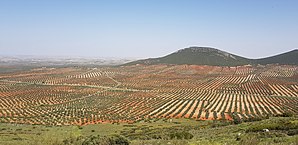
 Mora - landscape with olive trees
|
||
| coat of arms | Map of Spain | |

|
|
|
| Basic data | ||
| Autonomous Community : | Castile-La Mancha | |
| Province : | Toledo | |
| Comarca : | Mancha Alta de Toledo | |
| Coordinates | 39 ° 41 ′ N , 3 ° 47 ′ W | |
| Height : | 715 msnm | |
| Area : | 168.57 km² | |
| Residents : | 9,718 (Jan 1, 2019) | |
| Population density : | 57.65 inhabitants / km² | |
| Postal code : | 45400 | |
| Municipality number ( INE ): | 45106 | |
| administration | ||
| Website : | Mora | |
Mora is a small town and a central Spanish municipality ( municipio ) with 9,718 inhabitants (at January 1, 2019) in the province of Toledo in the Autonomous Community of Castile-La Mancha .
Location and climate
The small town of Mora is a good 36 km (driving distance) southeast of Toledo in the historic province of La Mancha at an altitude of approx. 715 m ; to Madrid it is almost 100 km north. The next larger towns are Orgaz (approx. 14 km southwest) and Sonseca (approx. 22 km west). The climate in winter is harsh, but in summer it is dry and warm; the sparse rain (approx. 430 mm / year) falls mainly in the winter months.
Population development
| year | 1857 | 1900 | 1950 | 2000 | 2017 |
| Residents | 6,459 | 7,795 | 10,844 | 9,371 | 9,853 |
Despite the rural exodus in the 20th century, the population of the small town was always between 9,300 and 10,800.
economy
The area around Mora was and is essentially agricultural, with viticulture ( La Mancha DO ) and larger olive tree plantations playing important roles; the small town itself served as a craft and mercantile center for the surrounding villages.
history
Although no prehistoric , Roman and Visigoth finds have been made, the presence of settlers and soldiers in the area is likely. The castle (Castillo de Mora) already existed in the time of Abd ar-Rahmans III. in the 10th century. In 1085 the area was named by Alfonso VI. recaptured ( reconquista ) , but shortly afterwards occupied again by the Berber Almoravids . It was not until Alfonso VII (reigned 1126–1157) that the La Mancha region finally became Christian around 1130. In 1172 the place and castle were given over to the Order of Santiago . Despite the destruction during the Comuneros uprising (1520-1522), the city experienced a heyday in the 16th century until it finally - like many places in the La Mancha region - sank into insignificance.
Attractions
- The Iglesia Santa María de Altagracia was rebuilt after the destruction during the Comuneros uprising (1521) with strong references to the Mudejar style . The nave consists of four ribbed yokes . Focus inside the church is stocked with numerous panel paintings in the Spanish-Flemish style altarpiece (retablo) .
- The Convento de San Eugenio , a former Franciscan monastery in the Mudejar style from the 16th century, existed until it was disamorted in 1835.
- The town hall (ayuntamiento) is a neo-Moorish building from the years 1927–1930.
- Surroundings
- On a rock about 3 km east of the city are the ruins of the Castillo de Mora (also Castillo de Peñas Negras ).
Personalities
- Gabriel Cano de Aponte (1665–1733), Governor of Chile
- Manuel de Salamanca (around 1695–1775), governor of Chile
- Gabino Díaz Merchán (* 1926), Archbishop of Oviedo
Web links
- Mora, sights - photos + information (Spanish)
- Mora, buildings - photos + information (Spanish)
Individual evidence
- ↑ Cifras oficiales de población resultantes de la revisión del Padrón municipal a 1 de enero . Population statistics from the Instituto Nacional de Estadística (population update).
- ↑ Mora - climate tables
- ↑ Mora - population development
- ↑ Mora - story
- ↑ Mora - altarpiece
- ^ Mora - Castillo

