Mosbach (Rhine)
|
Mosbach Belzbach, Weilburger Bach |
||
|
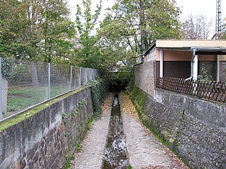
canalised course with tunnel under the right-hand Rhine stretch |
||
| Data | ||
| Water code | DE : 25132 | |
| location |
Taunus
|
|
| River system | Rhine | |
| Drain over | Rhine → North Sea | |
| source | as Weilburger Bach southeast of the Hohe Wurzel im Taunus 50 ° 5 ′ 49 ″ N , 8 ° 8 ′ 27 ″ E |
|
| Source height | 425 m above sea level NHN | |
| muzzle | near Biebrich in the Rhine Coordinates: 50 ° 2 ′ 15 ″ N , 8 ° 13 ′ 53 ″ E 50 ° 2 ′ 15 ″ N , 8 ° 13 ′ 53 ″ E |
|
| Mouth height | 83 m above sea level NHN | |
| Height difference | 342 m | |
| Bottom slope | 30 ‰ | |
| length | 11.3 km | |
| Catchment area | 14.1 km² | |
| Left tributaries | Aunelbach | |
| Big cities | Wiesbaden | |
|
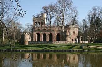
Pond with Mosburg |
||
The Mosbach in the Hessian state capital Wiesbaden is an 11.3 km long, orographically right tributary of the Rhine . In the upper reaches it bears the names Weilburger Bach and Belzbach .
course
The brook rises as Weilburger Bach to the south at an altitude of 425 m on the southern slope of the Hohe Wurzel ( 618 m ) in the Taunus . The seepage spring, protected as a biotope , is located between Georgenborn in the Rheingau-Taunus district and the Chausseehaus group of houses , which is part of the Dotzheim district of the Hessian capital Wiesbaden . The forest around the source is naturally in the Wiesbadener Hochtaunus ( Hochtaunus ), the valley below to the Rheingau-Wiesbadener Vortaunus ( Vortaunus ). The stream then flows in a south-easterly direction, crosses under the L 3038 and Rheingauer path as well as the Alte Rheingauer Straße, which connect the Chausseehaus with Georgenborn and over the Grauen Stein with Walluf . Within the Waldwiesental valley, the 600 m long Aunelbach flows from the left, which rises in the Weilburger valley at the source of the Aunel. The stream continues to flow west of the Kohlheck settlement to the sites of the former Grundmühle and Bossemühle. The Weilburger Tal is an important local recreation area , for which the construction of a variety of leisure facilities was planned in the 1970s.
To the east of the Dotzheim forest cemetery , the brook reaches the center of Dotzheim, which it partially piped through in a south-easterly direction under the new name of Belzbach. The stream was renatured in 2018 at the house of the clubs in Wiesengrund . The Belzbach now runs further south-east in the Rheingau natural area , parallel to the Aartalbahn between the Sauerland settlement and the artists' quarter of the street mill, which today serves as a restaurant. Then the brook enters the local district of Biebrich and is now called Mosbach. It crosses under the Schiersteiner Strasse / Bundesautobahn 643 at the Kahlemühle and flows in the Lohmühltal between the Gräselberg settlement and the Waldstrasse district with the former Waldstrasse station . The Spätmühle no longer exists, while the Lohmühle still exists as an excursion restaurant. The Mosbach runs along the meadow of the traditional Gibber Curb , crosses under the Bundesautobahn 66 , crosses the Gibb settlement, crosses the right stretch of the Rhine at the Wiesbaden-Biebrich train station and the Äppelallee and then enters the Biebrich Castle Park .
In the castle park, the Mosbach forms the Mosburgweiher on the Mosburg , flows along the venues of the Wiesbaden International Whitsun Tournament and flows west of the Biebrich Castle into the Upper Rhine . At the mouth, the average discharge is 83.1 liters per second.
natural reserve
The source of the Weilburger Bach belongs to the Rhein-Taunus Nature Park and is part of the City of Wiesbaden landscape protection area and the FFH area beech forests north of Wiesbaden . Below the L 3038, the Waldwiesental belongs to the almost 40 hectare FFH area Weilburger Tal-Klingengrund . The meadow in Klingengrund with Großseggenried and wet fallow as well as the surrounding alder forest are legally protected as biotopes .
Web links
Individual evidence
- ↑ a b c d e f projects on the Mosbach system . Website of the City of Wiesbaden, accessed on June 9, 2020.
- ↑ a b c Natureg Viewer , Hessian State Office for Nature Conservation, Environment and Geology , see protected areas . Retrieved June 8, 2020.
- ↑ a b Basic data acquisition for the FFH area 5914-302 "Weilburger Tal-Klingengrund" , accessed on June 9, 2020.
- ↑ Geographical Land Survey 1: 200,000 - Natural Spatial Structure of Germany, sheet 138 , 1971.
- ^ Duchy of Nassau 1819-47. Wiesbaden. Historical maps. In: Landesgeschichtliches Informationssystem Hessen (LAGIS). Hessian State Office for Historical Cultural Studies (HLGL), accessed on June 8, 2020 .
- ↑ Renaturation of the Belzbach in Dotzheim at the house of associations , website of the city of Wiesbaden, accessed on June 8, 2020.
- ^ Duchy of Nassau 1819-46. Wiesbaden. Historical maps. In: Landesgeschichtliches Informationssystem Hessen (LAGIS). Hessian State Office for Historical Cultural Studies (HLGL), accessed on June 8, 2020 .
- ↑ Weilburger Tal-Klingengrund in Germany , www.protectedplanet.net, accessed on June 9, 2020.
- ↑ Documents on the protected area , accessed on June 9, 2020.


