
Wiesbaden-Dotzheim
 district of Wiesbaden |
|
|---|---|
  |
|
| Coordinates | 50 ° 4 '23 " N , 8 ° 11' 37" E |
| height | 130– 608 m above sea level NN |
| surface | 18.27 km² |
| Residents | 27,498 (Dec. 31, 2019) |
| Population density | 1505 inhabitants / km² |
| Proportion of foreigners | 20.7% (Dec. 31, 2019) |
| Incorporation | Apr 1, 1928 |
| Post Code | 65199, 65201 |
| prefix | 0611 |
Administration address |
Im Wiesengrund 14 65199 Wiesbaden |
| Website | www.wiesbaden.de |
| politics | |
| Mayor | Harald Kuntze ( Greens ) |
| Deputy Mayor | Joachim Thiemann ( CDU ) |
| Source: State Capital Wiesbaden: EWZ - HW on December 31, 2019 ( Memento from February 3, 2020 in the Internet Archive ) | |


Dotzheim is a district of the Hessian state capital Wiesbaden and with over 27,000 inhabitants and over 18 square kilometers the second largest district in terms of population and area.
Geographical location
The old town center of Dotzheim is located around three kilometers west of Wiesbaden city center at the point where the Weilburger Bach enters the Taunus foreland as the Belzbach from the wooded valley of the Vordertaunus , and the valley of which extends in a south-easterly direction to the Biebrich Castle Park , where the water's name is is known here as Mosbach . The settlement in the northern edge of the forest: in the district Dotzheim a number of large housing estates around the village group Kohlheck the settlement, in the southeast on Belzbach / Mosbach Talheim the settlement, the southwest and higher up Sauerland and finally west of the old town center, the high-rise estate rogue ditch with the Helios Dr. Horst Schmidt Clinics Wiesbaden . Since the Dotzheim district includes the northern part of the Schierstein district, the northern part of the Freudenberg settlement in the southwest and the Märchenland settlement in the west also belong to Dotzheim. In the north, the district encompasses the wooded southern slopes of the Taunushauptkamm with the Schläferskopf upstream to the city limits on the Rheinhöhenweg . Here, near the summit of the Hohe Wurzel, lies the highest point of both Dotzheim and all of Wiesbaden at 608 meters.
Dotzheim is surrounded by the Wiesbaden districts of Frauenstein in the west, Schierstein in the south, Biebrich and Rheingauviertel in the southeast and Klarenthal in the east. The border to the Klarenthal district is largely identical to the course of the Aartalbahn . In the vicinity of the Iron Hand there is a short shared border with the district of Northeast . Beyond the city limits in the north are the forest areas of the Taunusstein districts of Hahn and Bleidenstadt .
The approximately 10 hectares of vineyards of the Dotzheimer Judenkirsch , after the Judenkirsche, are located on the sunny south-west slopes of the Belzbach / Mosbach valley . Physalis , also called bladder cherry (sometimes also spelled Jewish church true to the dialect ), which belong to the Rheingau wine-growing region .
history
The oldest evidence of settlement in Dotzheim are five Celtic stone box graves made of uncut quartzite slabs. The finds date from the early Iron Age , around 400 BC.
In 222 the Romans Fortunatus and Sejus donated an altar that could be saved as a fragment.
The first written documents mentioning Dotzheim by name have only been in existence since 1128: At that time, Archbishop of Mainz Adalbert I of Saarbrücken gave the Mainz cathedral chapter income from the Archbishopric's Dotzheim possessions. Pope Lucius III confirmed the ownership of 25 churches in 1184 - including that of Dotzheim.
In the 13th and 14th centuries lived some noble families who were called von Dotzheim and possibly owed their name to the village.
The Dotzheimer Dorfgericht was first mentioned in writing in 1386 and can therefore be seen as the beginning of local self-government.
In 1610 around 50 percent of the houses were destroyed by two fires. On February 21st three houses, three barns and two stables went up in flames, on April 5th another 29 houses, 24 barns, 14 stables and 18 wine press houses. In both cases the cause was arson, for which the blacksmith Michael Cron was convicted in 1613.
In 1644 almost all of the residents of Dotzheim fled their hometown. The reason for this was the Thirty Years War . It took a very long time to overcome all the consequences of the war.
In 1695 the Protestant parsonage was built opposite the village church, and a schoolhouse followed in 1698. The increase in the population in the 18th century was also due to the fact that many construction workers who worked in the spa town of Wiesbaden lived in Dotzheim.
The route connection between Dotzheim and Wiesbaden was initially established through the Old and New Dotzheimer Weg, the latter was built around 1701. In 1818 the Dotzheimer Straße was laid out between the two paths and expanded as a road between 1834 and 1838 .
In 1889 Dotzheim was connected to the route network of what was then the Langenschwalbacher Bahn . This railway line, closed in 1986 by the Deutsche Bundesbahn , is now used by the Nassau Tourist Railway as a museum railway. The heritage-protected Dotzheim station is the home station of the historic trains and the location of a small railway museum.
At the turn of the century the village got a new town hall, three schools and a forest cemetery . In 1906 it was connected to the local gas, water and electricity supply network. In addition, a line of the Wiesbaden tram was set up via the city center to Bierstadt , which was replaced in 1948 by the line of the Wiesbaden trolleybus . Since 1961 only buses have been in use, most of which are operated by ESWE .
Probably the most important historical turning point in the history of Dotzheim was its incorporation into Wiesbaden in 1928. Coincidentally, this was exactly 800 years after it was first mentioned in writing.
During the Nazi era , barracks were built on the Kohlheck and the Freudenberg. Dotzheim survived the Second World War almost undamaged. Evidence of a possibly attempted bombing of Dotzheim is given by deep, wide craters in the northwest bay of the Weilburger valley.
The stumbling blocks that were laid there report the fate of Jewish citizens in Dotzheim.
After the Second World War , several new settlements emerged around Dotzheim, such as B. Kohlheck , Freudenberg , Schelmengraben and the Sauerland .
politics
Election results for the local council
Since 1972, the local council of the Dotzheim district has been elected as part of the local elections in Hesse . The following distribution of seats resulted from the individual election results :
| CDU | SPD | GREEN | FDP | REP | LEFT | total | |
| 2016 | 5 | 5 | 2 | 2 | 0 | 1 | 15th |
| 2011 | 5 | 5 | 3 | 1 | 0 | 1 | 15th |
| 2006 | 6th | 5 | 2 | 1 | 1 | 0 | 15th |
| 2001 | 6th | 5 | 1 | 2 | 1 | 0 | 15th |
| 1997 | 6th | 6th | 1 | 0 | 2 | 0 | 15th |
| 1993 | 6th | 6th | 2 | 1 | 0 | 0 | 15th |
| 1989 | 5 | 8th | 1 | 1 | 0 | 0 | 15th |
| 1985 | 7th | 7th | 1 | 0 | 0 | 0 | 15th |
| 1981 | 8th | 6th | 0 | 1 | 0 | 0 | 15th |
| 1977 | 8th | 7th | 0 | 0 | 0 | 0 | 15th |
| 1972 | 6th | 8th | 0 | 1 | 0 | 0 | 15th |
Attractions

Old Town Hall

Local administration

Fountain at Pfarrer-Luja -Platz

Commemorative plaque on the Dotzheimer church for Rev. Luja
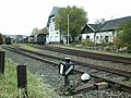
Wiesbaden-Dotzheim train station
Ev. Erlöserkirche , Wbn.-Sauerland, architect Wolfgang Thrun

Catholic Church of the Visitation on the Kohlheck

War memorial in the forest cemetery


- Aartalbahn , a listed railway line, on which today the Nassau Tourist Railway runs between the Dotzheim and Hohenstein stations .
- Aartalbahnmuseum in Dotzheim station
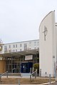
- Catholic parish church of St. Joseph with French-Alsatian organ
- Freudenberg Castle
sons and daughters of the town
- Salomon Herxheimer (1801–1884), rabbi , Bible translator
- Johann Christian Reinhard Luja (1767–1847), Protestant pastor and local history researcher
Web links
- Dotzheim on the website of the state capital Wiesbaden
- Dotzheim, City of Wiesbaden. Historical local dictionary for Hessen. In: Landesgeschichtliches Informationssystem Hessen (LAGIS).
- Literature on Wiesbaden-Dotzheim in the Hessian Bibliography
- Dotzheimer Heimatmuseum
Individual evidence
- ↑ Harald Kuntze is the new Dotzheim mayor. In: Wiesbaden Courier . September 20, 2019, accessed September 20, 2019 .
- ^ Klaus Kopp: Dotzheim - From the Franconian hamlet to the largest village in the Nassauer Land , ISBN 3-924401-16-0 .
- ↑ Annals of the Society for Nassau Antiquities and Historical Research, Volume thirtieth, 1899 , page 117
- ^ Sigrid Russ: Cultural monuments in Hessen: Monument topography of the Federal Republic of Germany. Wiesbaden: City extensions within the Ringstrasse. Theiss 2005, ISBN 978-3-80-622010-0 , page 610.
- ↑ 125 years of Wiesbaden public transport, Chapter 18 , on eswe-verkehr.de
- ↑ Turntable Online: The trolleybus, not the Wiesbaden residents' favorite child , accessed on July 7, 2011
- ↑ List of stumbling blocks in Wiesbaden-Dotzheim

Inner districts: center | Northeast | Rheingauviertel | Southeast | Klarenthal | West end
Outer districts: Auringen | Biebrich | Bierstadt | Breckenheim | Delkenheim | Dotzheim | Erbenheim | Frauenstein | Hessloch | Igstadt | Kloppenheim | Mainz-Amöneburg | Mainz-Kastel | Mainz-Kostheim | Medenbach | Naurod | Nordenstadt | Rambach | Schierstein | Sonnenberg