
Pwani (region)
| Pwani | |
|---|---|
  |
|
| Basic data | |
| Country | Tanzania |
| Capital | Kibaha |
| surface | 33,539 km² |
| Residents | 1,098,668 (2012) |
| density | 33 inhabitants per km² |
| ISO 3166-2 | TZ-19 |
Coordinates: 7 ° 11 ′ S , 37 ° 44 ′ E

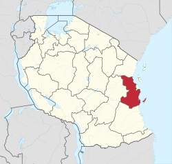
Pwani is one of a total of 31 regions in Tanzania . The capital is Kibaha . Pwani borders the Tanga region in the north, the Indian Ocean and Dar es Salaam region in the east, the Lindi region in the south and the Morogoro region in the west .

geography
The region is 33,539 square kilometers and had 1,098,668 inhabitants in 2012 (census). Most of the region lies in the coastal strip with a height of up to 100 meters above sea level. Only in the west does the land slowly rise to a high plateau over 100 meters. The region is drained by the Rufiji , Ruvu and Wami rivers , which all flow into the Indian Ocean.
The climate in Pwani is tropical, Aw according to the effective climate classification . The annual rainfall of 800 to 1000 millimeters falls in two rainy seasons . Short showers in the months of October to December and heavy rains in the months of March to June. As is typical for coastal strips, the air is hot and humid with an average daily temperature of 30 degrees Celsius. Sea breezes make the climate pleasant from June to September.
|
Climate table Kibaha
Source: climate-data.org
|
||||||||||||||||||||||||||||||||||||||||||||||||||||||||||||||||||||||||||||||||||||||||||
history
The name "Pwani" means "coast" in Swahili . In the colonial times, the area was part of the Eastern Province. With independence in 1961, Pwani became part of the coastal region with the capital Dar es Salaam. During the reorganization in 1972, the coastal region with the four districts of Kisarawe, Rufiji, Bagamoyo and Mafia was created. The administrative center remained in Dar es Salaam. In 1979, Kibaha District was formed from the northern part of Kisarawe District and the southern part of Bagamoyo District, and Kibaha became the administrative center. In July 1995 the region was given its present form, the Mkuranga district was split off from Kisarawe.
Administrative division
The region is divided into the following seven districts:
| District | Capital | Area km² |
Population (2012) | Population (2019) |
|---|---|---|---|---|
| Bagamoyo | Bagamoyo | 9,842 | 311,740 | 361,727 |
| Kibaha | Kibaha | 1,812 | 198,697 | 237.946 |
| Kisarawe | Kisarawe | 4,464 | 101,598 | 116,541 |
| Rufiji | Utete | 9,485 | 217.274 | 127.072 |
| Kibiti a) | Kibiti | 3,854 | 116.079 | |
| Mkuranga | Mkuranga | 2,432 | 222.921 | 252,837 |
| mafia | Kilindoni | 518 | 46,438 | 51,302 |
| Pwani region | Kibaha | 32,407 | 1,098,668 | 1,265,504 |
| The area data differ in different sources. a) Kibiti was split off from Rufij district after 2012. |
||||
population
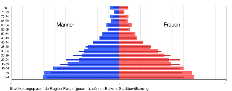
The population pyramid shows the broad base for many African regions, which is an indication of high birth and death rates and a youthful age structure. In the urban population, there is a bulge in the 15 to 24 age group that indicates immigration. The bulge is particularly pronounced in women.

Facilities and services
- Education: There are 620 schools with 3980 school classes in the region (as of 2019).
- Health: 337 health centers are available for the medical care of the population.
- Water: Three quarters of the population had access to clean and safe water (as of 2016).
Economy and Infrastructure
The main industry is agriculture. 80 percent of the population live from it, it contributes 60 percent to the regional income.
AgricultureThe main staple foods in the region are corn, cassava, rice, cowpeas, millet, legumes, sesame seeds, sweet potatoes and sesame seeds. Cashew nuts, coconuts, cotton, sesame, oranges, mangoes, watermelons, passion fruits and pineapples are grown for sale (as of 2019). A third of the 250,000 households own farm animals. The animals kept most frequently are poultry and cattle (as of 2016). forestryThe coastal forests cover a third of the country. They are home to hundreds of endemic plant and animal species. The forest is heavily exploited by logging and charcoal production, so that 300,000 hectares are lost every year (as of 2017). |
 |

Fishing
Above all, people live from fishing on the coast, and here especially on Mafia Island. Nearly half of the 4,500 fishing licenses were issued in this district. But the rivers are also rich in fish and in 2017 360 tons of fish from ponds were sold, especially in the Rufiji district. Over 2000 tons of fish were caught from the sea in the same year.
Industry and commerce
Industry and commerce are an important emerging branch of the economy. In 2019 there were a total of 1200 companies in the region, of which 700 are micro, 350 small, 100 medium and 50 large. Small and micro enterprises were mainly sewing shops, food processors, sawmills and brickworks. The medium-sized and large companies covered a broad spectrum, from steel production and construction material production to leather, textile and food processing.
tourism
The main tourist attractions are Saadani National Park , the Indian Ocean beaches and the historical sites in Bagamoyo .
traffic


Due to the proximity to Dar es Salaam, the region is easily accessible by all means of transport.
- Railway: Three railway lines run through the region: the Tanganyika Railway , which runs from Dar es Salaam to Dodoma and further to the west, the railway line from Dar Es Salaam to Mbeya in the southwest, and the railway to Tanga in the north, which branches off the Tanganyika Railway at Mlandizi . The section from Dar es Salaam to Mororgoro will be converted to standard gauge (as of 2019).
- Road: The national road from Dar es Salaam to Dodoma runs right through the region. From here the national road T2 branches off to the north at Chalinze . This connects Dar es Salaam with the Tanga region and continues to Kenya. The national road T7 runs from Dar es Salaam to Lindi through the south of the region.
- Airport: Julius Nyerere Airport is only 40 kilometers from the regional capital.
- Port: In 2018, the nearby port of Dar es Salaam handled 1,744 ships and 1.9 million passengers.

Nature reserves, sights
- Saadani National Park: The 1062 square kilometer national park was established as a nature reserve in 1969 and made a national park in 2002. It lies on the border with the Tanga region, on the Indian Ocean, so that wildlife viewing can be combined with a beach holiday.
- Selous Game Reserve: This 50,000 square kilometers largest game reserve in Africa was declared a UNESCO World Heritage Site in 1982 . It is located in the southwest of Pwani, the reserve also includes parts of the Mororgoro, Lindi and Ruvuma regions. In addition to hundreds of species of birds, it is also home to a large number of elephants, rhinos and hippos, but above all one of the largest populations of buffalo in Africa.
- Bagamoyo: Bagamoyo was once an important port and the penultimate stop for slave and ivory caravans. In 2006 it was declared a UNESCO World Heritage Site. The ruins of Kaole with a mosque from the 13th century are particularly worth seeing.
- Mafia : The island of Mafia is located twenty kilometers from the mouth of the Rufiji River in the Indian Ocean. It is fifty kilometers long and surrounded by a barrier reef, half of which has been designated as a marine park. 50 different types of coral, 460 types of fish and 5 types of turtles live in it.
Web links
Individual evidence
- ^ Tanzania Regional Profiles, 06 Pwani Regional Profiles. (pdf) The United Republic of Tanzania, 2016, p. 16 , accessed on December 17, 2019 .
- ^ Maps of the World. Russian Army Maps, S. Map 500k - xb37-3, Map 500k - xb37-4 , accessed December 17, 2019 (Russian).
- ↑ Climate Pwani: Temperature, climate graph, Climate table for Pwani - Climate-Data.org. Retrieved December 17, 2019 .
- ^ Coast Region, Investment Profile. (pdf) Prime Minister's Office, Regional Administration and Local Government, January 2015, pp. 2–4 , accessed on December 17, 2019 .
- ^ Kibaha District Council, Investment Profile. (PDF) July 2017, p. 3 , accessed on February 21, 2020 .
- ↑ History | Coast Region. Retrieved December 17, 2019 .
- ^ Pwani Region Investment Guide. (pdf) 2019, p. 12 , accessed on December 17, 2019 .
- ^ National Bureau of Statistics: 2012 Population and Housing Census. (pdf) March 2013, accessed on September 7, 2019 (English).
- ^ Pwani Region Investment Guide. (PDF) 2019, p. 14 , accessed on April 3, 2020 .
- ^ Tanzania Regional Profiles, 06 Pwani Regional Profiles. (pdf) The United Republic of Tanzania, 2016, p. 23 , accessed on November 3, 2019 .
- ↑ a b Pwani Region Investment Guide. (pdf) The United Republic of Tanzania, 2019, pp. 17-18 , accessed on December 17, 2019 .
- ↑ water. Regional Administration and Local Government, accessed December 17, 2019 (Swahili).
- ^ Pwani Region Investment Guide. (pdf) The United Republic of Tanzania, 2019, pp. 18-22 , accessed on December 17, 2019 .
- ^ Tanzania Regional Profiles, 06 Pwani Regional Profiles. (pdf) The United Republic of Tanzania, 2016, p. 130 , accessed on November 3, 2019 .
- ↑ carbon storage has dropped by 40% in Pwani Tanzania! | WWF. Retrieved December 18, 2019 .
- ↑ a b Pwani Region Investment Guide. (pdf) The United Republic of Tanzania, 2019, pp. 30–33 , accessed on December 17, 2019 .
- ↑ THE 15 BEST Things to Do in Pwani Region - 2019 (with Photos) - TripAdvisor. Retrieved December 17, 2019 .
- ^ Pwani Region Investment Guide. (pdf) The United Republic of Tanzania, 2019, pp. 5–6 , accessed on December 17, 2019 .
- ^ Trunk Roads Network. Retrieved December 17, 2019 .
- ^ Tanzania Standard Gauge Railway to Start Operations in December 2019. In: TanzaniaInvest. July 10, 2019, Retrieved December 17, 2019 (American English).
- ^ Tanzania Trunk Road Network. The United Republic of Tanzania, accessed December 17, 2019 .
- ↑ Google Maps. Retrieved December 17, 2019 .
- ↑ Tanzania in Figures 2018. (pdf) National Bureau of Statistics, June 2019, p. 66 , accessed December 17, 2019 .
- ↑ a b Tanzania in Figures 2018. (pdf) National Bureau of Statistics, June 2019, pp. 8–9 , accessed on December 17, 2019 .
- ↑ Daniela Eiletz-chewing: Saadani National Park. In: Safari Insider. Accessed December 17, 2019 (German).
- ↑ Tourist Attractions in Selous Game Reserve, Things To See. In: Selous Game Reserve. January 17, 2014, accessed November 20, 2019 (American English).
- ↑ UNESCO World Heritage Center: The Central Slave and Ivory Trade Route. Retrieved December 18, 2019 .
- ↑ Kaole Ruins | Bagamoyo, Tanzania Attractions. Retrieved December 18, 2019 .
- ↑ ABOUT MAFIA ISLAND - TANZANIA | Mafia Island. Retrieved December 18, 2019 .
Arusha | Dar es Salaam | Dodoma | Geita | Iringa | Kagera | Katavi | Kigoma | Kilimanjaro | Lindi | Manyara | Mara | Mbeya | Morogoro | Mtwara | Mwanza | Njombe | Pemba Kaskazini | Pemba Kusini | Pwani | Rukwa | Ruvuma | Shinyanga | Simiyu | Singida | Songwe | Tabora | Thong | Unguja Kaskazini | Unguja Kusini | Unguja Mjini Magharibi