
Grainberg-Kalbenstein and Saupurzel nature reserve
|
Grainberg-Kalbenstein and Saupurzel
|
||
 View of the Grainberg |
||
| location | Karlstadt , Eußenheim , Main-Spessart district , Bavaria | |
| surface | 3.019 km² | |
| Identifier | NSG-00743.01 | |
| WDPA ID | 378088 | |
| Geographical location | 49 ° 59 ' N , 9 ° 46' E | |
|
||
| Setup date | 10/20/2005 | |
| particularities | Geotope | |

Grainberg-Kalbenstein and Saupurzel is a nature reserve in Karlstadt and Eußenheim in the Lower Franconian district of Main-Spessart in Bavaria .
location
The nature reserve (NSG) is the northernmost section of the fauna-flora-habitat area main valley slopes between Gambach and Veitshöchheim . It begins south of the hamlet of Gambach on the ascent to the Grainberg and follows the Main for about 5 kilometers at varying widths in a south-easterly direction . It ends in the east of Karlstadt north of Bundesstraße 26 .
description
The approximately 302 ha area is a complex dry area network . Here you can find shell limestone bastions , red sandstone terraces , vineyard walls , borders, hedges, drifting sands , warmth-loving forests, various dry grassland and wild herb locations. In 1941, parts of the Grainberg and Kalbenstein were designated as an NSG for the first time. This makes it one of the oldest NSGs in Lower Franconia. It was initially initiated as the Gregor Kraus Park ( full professor of the Botanical Faculty in Würzburg, 1841–1915), which collected scientific data in this area. In 1904 he acquired around 2 hectares on Kalbenstein. These were the cornerstone for the NSG designated in 1941 with around 90 hectares. In 2005 it was expanded to over 300 ha and the Natura2000 area boundaries were included.
The shell limestone of the Mainfränkische Platten in the southeast meets the red sandstone of the Spessart here . Here you can see the alternation between the older layers of red sandstone and the younger Lower Muschelkalk above them. The eroding power of the Main in the Ice Ages created mighty bastions and scree slopes. On the side of the Muschelkalk step away from the wind and on Saupurzel mountain, drifting sand from the main valley was deposited.
The arid areas around Karstadt are the richest in flora and fauna in Bavaria. Less than 600 millimeters of precipitation per year, a continental climate, high solar radiation with shell limestone poor in fine earth and sandy soil offer a specialist habitat. There are still remnants of the historical low and medium forest use here, but forests hardly stand a chance here. That is why steppe and Mediterranean plants thrive here, some of which immigrated here at the end of the last ice age. More than 20 types of orchid , blue-green fiber umbrella , types of sun rose , feather grass and the earth sedge are just some of the plant specialists found here. 1998 this has Karlstadter saxifrage -Habichtskraut discovered. It is one of five only endemic plant species. Particularly noteworthy are the field wild herb societies, which are only found sporadically and are considered to be of national importance in the Karlstadter area. With Rock Bunting , Woodlark , owl and Segelfalter , Bluebird and other butterfly species, red - and blue-winged grasshopper and CALLIPTAMUS ITALICUS endangered species are native here.
With the designation as an FFH area and the extension of the NSG implemented in 2005, additional valuable areas could be protected. The centuries-long use of grazing or logging, alien species and the intensification of agriculture threaten the area.
Protection purpose
According to the ordinance and from the point of view of species and biotope protection, it is a complex arid area and is considered to be an outstanding section of the state-wide dry network axis in the shell limestone and to restore a supraregional important focus for sandy grass ecosystems in Bavaria. To maintain and optimize the central occurrence of the endemic plants and plant communities, the nationwide significant arable wild flora, the high-ranking geotopes and ground monuments and the structures of the middle and coppice forests.
Geotopes
There are four geotopes designated by the Bavarian State Office for the Environment (LfU) in the NSG .
Kalbenstein shell limestone profile

The Kalbenstein lies in the middle of the NSG. On the rock walls of the Kalbenstein, an almost complete profile is made accessible by a 90-meter-thick sequence of limestone and marl stones of the Lower Muschelkalk (wave limestone). In 1784 a landslide exposed the rock face. A profile through the limestone and marl of the Lower Muschelkalk is exposed on the steep rock faces on the slope of the Main. The thin-bank limestones have wave-like structures as a characteristic feature, which is why the sequence is also known as wavy limestone.

At the beginning of the Mesozoic Era ( Mesozoic Era), a shallow basin occupied large parts of Germany. During the time of the shell limestone about 245 million years ago, a shallow inland sea was formed in this Germanic basin . It was separated from the open ocean in the southeast by a continental threshold ( Vindelizian threshold ). It was only connected to the Medieval Mediterranean ( Tethys ) via a few straits .
A hot and dry climate in the shallow sea caused evaporation with calcium precipitation and calcium separation by organisms. From the surrounding mainland, only a small amount of material could be carried into the basin and a limestone sequence with intercalations of mudstone , dolomite , gypsum and salt formed.
The exposed rocks show that the sea was quite salty and hostile to life back then. As a result, only a few creatures that immigrated from the open ocean made their home here. An alternating layer of fossil-poor corrugated limestone packages with very shell-rich rock banks is visible. Hard and fossil-rich limestones form steep steps and ledges. Together with their fossil content, they show a structure of the layer sequence. This is known as stratigraphy (guide benches). The uppermost steep step of the slope forms the leading horizon of the foam limestone banks. These consist of lime balls ( ooids ) and shell fragments and smell foamy. Further, the Spiriferina -Bank and Terebratelbänke , each for frequently occurring there brachiopods are named (brachiopods).
In 1784, the year of the millennium flood on the Main, the wall of the climbing garden in the area of the Kalbenstein was exposed by a landslide. The limestone is traversed by large fissures and faults . Water-permeable red tones of the red sandstone lie beneath the fractured shell limestone . There, seeping water accumulates and together with the clay it acts like a lubricant. Together with the erosion effect of the Main and heavy rainfall, large amounts of rock slid down. Even today there are minor rock falls and landslides.
The Kalbenstein shell limestone profile is a geoscientifically valuable geotope (geotope number: 677A009) and has been awarded the official seal of approval for Bavaria's most beautiful geotopes .
A via ferrata leads through the rock face. An information board is set up on site.
Flying sands on the Saupürzel

The 300 meter high Saupürzel mountain is located in the NSG east of Karlstadt. Here drifting sands from the Main valley have spread and created a field of dunes. The formation of these dunes is documented on site by display boards.
The drifting sands at Saupürzel are designated as a geoscientifically significant geotope (geotope number: 677R011).
Former quarry on Grainberg

The 315 meter high Grainberg mountain is located in the NSG south of Gambach. In the abandoned quarry, the lowest layers of the Lower Muschelkalk from the border yellow limestone to the wave limestone series are exposed. Several solid and hard grounds have developed above the border yellow limestone. Some of these are bored with fossil fuels (drillworm bank). During the construction of the Gambach-Edelweiß Geological Hiking Trail (2017), the break was exposed and the uppermost layers of the red sandstone exposed.
The former quarry on Grainberg is designated as a geoscientifically particularly valuable geotope (geotope number: 677A007).
Red sandstone profile from Gambach

The outcrop is located on the edge of the NSG south of Gambach. It is part of the profile on the Gambacher Steige . The sequence of layers from rock sandstone to Thuringian chirotheria sandstone is exposed on a footpath . Particularly here are the carnelian- dolomite layers in a preservation with a fossil soil horizon and root tubes. The Solling sandstone shows a typical formation with fluvial sedimentary structures. The "Geological hiking trail Gambach-Edelweiß" leads through several old quarries. These quarries are the type locality of the largest amphibian in geological history and the trace fossil Saurichnites gambachensis .
The red sandstone profile of Gambach is identified as a geoscientifically particularly valuable geotope (geotope number: 677A004).
Development through hiking trails, parking spaces, visitor information
The NSG is well developed through a number of local hiking trails. The circular hiking trail marked "K 1", which leads from Karlstadt to Gambach and back to Saupürzel, is recommended for experienced hikers. Two regional hiking trails also lead through large parts of the NSG: the Maintalwanderweg (marked blue "M") and the Karolingerweg (marked "K" on a yellow background).
Recommended parking spaces:
- east of Karlstadt north of the B 26 towards Arnstein
- at the glider airfield south of the B 27 in the direction of Eußenheim
- in Gambach at the music hall and at the sports field
The place around the "Edelweiss" on the Kalbenstein offers a particularly beautiful view of the Main Valley and the city of Karlstadt.
The month of April with the mass occurrence of pasque flowers in the entire NSG and the bloom of the Adonis flower near the "edelweiss", as well as May and June with the bloom of orchids and the sun rose as well as the bloom of the "edelweiss" are particularly recommended as visiting times Diptam .
See also
- List of nature reserves in the Main-Spessart district
- List of FFH areas in the Main-Spessart district
- List of geotopes in the Main-Spessart district
Picture gallery

View from the Grainberg to the Main

View of the Kalbenstein

Adonis

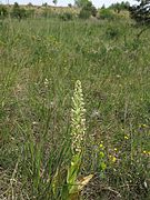
Purple Orchids

Flowering feather grass in May

Apennine sun rose

Diptame on the calving stone
Bock strap tongue
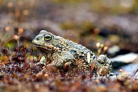
Natterjack toad in the NSG

Two blue Alexis guys


,_NSG_Grainberg-Kalbenstein,_Bayern.jpg)

Web links
Individual evidence
- ↑ 6124372 Main valley slopes between Gambach and Veitshöchheim. (FFH area) Profiles of the Natura 2000 areas. Published by the Federal Agency for Nature Conservation . Retrieved November 17, 2017.
- ↑ World Database on Protected Areas - Main valley slopes between Gambach and Veitshöchheim (English)
- ↑ Location of the nature reserve in the Bavaria Atlas (accessed on November 4, 2017).
- ↑ www.karlstadt.de, nature reserves in the administrative region of Lower Franconia (accessed on November 4, 2017)
- ↑ Ordinance of the nature reserve of October 20, 2005
- ↑ Bavarian State Office for the Environment, Geotope Muschelkalkprofil Kalbenstein SE von Gambach (accessed on March 22, 2020).
- ↑ Bavaria's most beautiful geotopes, Kalbenstein shell limestone profile (accessed on March 22, 2020)
- ↑ Bavarian State Office for the Environment, Geotop Flugsande am Saupürzel NE of Karlstadt (accessed on March 22, 2020).
- ^ Bavarian State Office for the Environment, Geotop former. Quarry on Grainberg S von Gambach (accessed on March 22, 2020).
- ↑ Bavarian State Office for the Environment, Geotop Buntsandstein-Profil WSW von Gambach (accessed on March 22, 2020).


Gable | Grainberg-Kalbenstein and Saupurzel | Gray heron colony at Salzberg | Kallmuth | Kreuzberg near Marktheidenfeld | Mäusberg-Rammersberg-Ständelberg | Gansbrunn Natural Forest Reserve | Schubertswald natural forest reserve | Romberg | Homburg ruins | Reason | Sodenberg goose | Spessartwiesen | Lower Schondratal | Weihersgrund