Put on
|
Put on
City of Siegen
Coordinates: 50 ° 55 ′ 57 ″ N , 8 ° 2 ′ 15 ″ E
|
|
|---|---|
| Height : | 287 (270-330) m |
| Area : | 5.27 km² |
| Residents : | 843 (December 31, 2016) |
| Population density : | 160 inhabitants / km² |
| Incorporation : | July 1, 1966 |
| Incorporated into: | Hut Valley |
| Postal code : | 57078 |
| Area code : | 0271 |
|
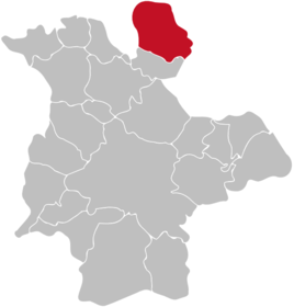
Location of Obersetzen in Siegen
|
|
Obersetzen is a district of the city of Siegen .
geography
Obersetzen is located in the north of Siegen and borders on Niedersetzen in the south, the Netphener districts of Dreis-Tiefenbach and Eckmannshausen in the southeast and Unglinghausen in the east, the Kreuztaler districts of Kredenbach and Ferndorf in the north and Buschhütten in the west.
The place is between 270 and 330 m altitude in the upper valley of the Setze, which rises about 1.5 km to the northwest and flows into the Ferndorf in Geisweid . The highest point in the district is an unnamed summit in the east with a height of 450.1 m . Other mountains are the Blecherother Schlag with a height of 435.2 m in the southeast or the 376.1 m high Hungenberg in the west.
history
Around the year 1300 Obersetzen was first mentioned in a document as "communitas setze". In 1705 eight Obersetzer families emigrated to East Prussia.
On March 30, 1774, the second day of Easter, the village of Obersetzen was destroyed by fire. 24 houses and 11 other buildings fell victim to the conflagration. A year after the fire, a school was built that was rebuilt in the 1870s and has been owned by the Heimatverein since 1983. According to an occupation census from 1815, 24 out of 33 workers worked as linen weavers at home. This changed with industrialization, when this work was replaced by machines and the residents made more and more money in mining and the iron and steel industry.
Until the municipal reorganization in 1966, the place belonged to the office of Netphen and on July 1, 1966 it became a district of the new town of Hüttental . Obersetzen has been part of Siegen since January 1st, 1975.
Population numbers
Population of the place:
|
|
|
|
Infrastructure
Obersetzen is on Kreisstraße 27, which leads from Geisweid via Niedersetzen and the town further north to Unglinghausen. The K 28 branches off in the village and leads west to Bottenbach / Buschhütten. The village is connected to Hüttentalstrasse via Geisweid and to the 45 federal motorway via the Siegen exit . The next train station is in Geisweid.
Obersetzen has a cemetery, a club house, the former Setzer elementary school (with Niedersetzen) and a day-care center.
Attractions
The chapel school was built in 1775 as a two-story half-timbered house with a bell tower in the middle. The service was held downstairs, while the children went to school upstairs. In the 1870s the school was moved downstairs and an apartment for the teacher was set up upstairs. After the construction of a larger schoolhouse due to the increased number of pupils from 92 around 1900 to 150 in World War I, the chapel school was used as a church service room and for church work from then on. From 1983 to 1987 the building was renovated by the Heimatverein and now serves as a local parlor and museum with various exhibits on everyday life, mining, agriculture, mining and the iron and steel industry.
In Obersetzen there is also a war memorial that was inaugurated on August 27, 1922.
Sports
The largest sports club in town is SV SET 1911 , the main focus of this club is on football , but there is also a small gymnastics department.
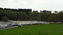
The soccer field is located a little away from the main town near the border with Buschhütten and was equipped with artificial turf in 2010.
Individual evidence
- ↑ a b c siwikultur.de: Kapellenschule Obersetzen
- ^ Dillenburg Intelligence News of the year 1774
- ^ Stephanie Reekers: The regional development of the districts and communities of Westphalia 1817 - 1967 . Aschendorff, Münster (Westphalia) 1977, ISBN 3-402-05875-8 .
- ^ Federal Statistical Office (ed.): Historical municipality directory for the Federal Republic of Germany. Name, border and key number changes in municipalities, counties and administrative districts from May 27, 1970 to December 31, 1982 . W. Kohlhammer, Stuttgart / Mainz 1983, ISBN 3-17-003263-1 , p. 336 .
- ↑ Otto Schaefer: The district of Siegen. Wins 1968.
- ↑ siegen.de: main resident population by district (updated regularly)
- ^ Community encyclopedia for the province of Westphalia. Publishing house of the Royal Statistical Bureau, Berlin 1887, ZDB -ID 1458761-0 , p. 112/113.
- ^ Community encyclopedia for the province of Westphalia. Publishing house of the Royal Statistical Bureau, Berlin 1897, pp. 114/115.
- ↑ gemeindeververzeichnis.de: District of Siegen
- ↑ genealogy.net: Freudenberg Office
- ↑ a b Michael Rademacher: German administrative history from the unification of the empire in 1871 to the reunification in 1990. City and district of Siegen. (Online material for the dissertation, Osnabrück 2006).
- ↑ Martin Bünermann, Heinz Köstering: The communities and districts after the municipal territorial reform in North Rhine-Westphalia . Deutscher Gemeindeverlag, Cologne 1975, ISBN 3-555-30092-X , p. 232 .
- ↑ Hartmut Eichenauer: Siegen ( Memento of the original from February 22, 2014 in the Internet Archive ) Info: The archive link was inserted automatically and has not yet been checked. Please check the original and archive link according to the instructions and then remove this notice. (PDF; 11.7 MB) , approx. 1995
- ↑ image of the warrior memorial on kulturgang.de


