
Supreme Mill (Gladbach)
| Supreme Mill
|
||
|---|---|---|
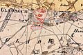
 The top mill on the original cadastral map |
||
| Location and history | ||
|
||
| Coordinates | 51 ° 11 '30 " N , 6 ° 25' 54" E | |
| Location |
|
|
| Waters | Gladbach | |
| Built | First documented mention in 1210 | |
| Shut down | 1943 by a bomb attack | |
| technology | ||
| use | Flour mill | |
| Grinder | 2 grinding courses | |
| drive | water wheel | |
| water wheel | undershot | |

The upper mill was a watermill with an undershot water wheel on the Gladbach in the city of Mönchengladbach .
geography
The Oberste Mühle was located on the left side of the Gladbach, at the former Weiher-Tor, at what is now the confluence of Weiherstrasse and Lüpertzender Strasse. It was the first mill on the Gladbach. Below was the Flieschermühle . The area on which the mill building stood has a height of approx. 62 m above sea level .
Waters
The Gladbach, (GEWKZ 28614), which is also the namesake of the city of Mönchengladbach, has been an important lifeline for centuries. It supplied the residents and a total of eight mills with water and was the origin of the flourishing textile industry in Mönchengladbach. The approximately 6.3 km long Gladbach rises in Waldhausen , crossed the districts of Pesch and Lürrip and flowed into the Niers at Uedding . Today it is mostly piped and flows from Volksbadstrasse at 1,904 m as an open channel along the Mönchengladbach – Düsseldorf railway line to the Niers. The catchment area of the body of water is 26.208 km 2 . The care and maintenance of the water is incumbent on NEW AG .
history
The upper mill was first mentioned in 1210, when Abbot Hermann I (1190–1200) acquired the mill together with the Fliescher and Krallsmühle from his own resources and bequeathed them to the monks' convent . The mill was an undershot fruit mill that was awarded by the convent with a lease . Over the course of time, this resulted in changes to the name of the mill. So the upper mill was also called Scherrenmühle , Scharrenmühle or Horns Mühle .
During the Thirty Years War the mill was burned down in November 1640. The same thing happened on September 19, 1642 when the barn belonging to the mill burned down when the city was liberated. After the liberation, the mill was rebuilt. From 1790 the monks managed the mill again. On October 8, 1803, Johann Compes bought the upper mill as part of the secularization for 7,700 francs . In 1840 the Horn brothers bought the mill and converted it into a hydropower-powered spinning mill . During the Second World War , the mill was destroyed in a bomb attack.
gallery

Former location of the supreme mill

The Geroweiher near the Supreme Mill

City wall at the previous location

Plaque of the former city fortifications
The supreme mill on the tranchot map 1803-1820

The Gladbach as an open channel
Signs show the course of the Gladbach canal


literature
- Hans Vogt: Lower Rhine water mill guide , 2nd edition. Niederrhein Association, Krefeld 1998, ISBN 3-00-002906-0 , pp. 497-499.
- Robert Lünendonk: On the trail of the Gladbach and its mills . 2008, ISBN 3-8375-0030-6 , 1st edition, pp. 54-55.
- Robert Lünendonk: The Niers and their mills . 2012, ISBN 978-3-8375-0741-6 , pp. 66-70.
Web links
Individual evidence
- ^ German basic map 1: 5000
- ↑ http://www.lanuv.nrw.de/fileadmin/lanuv/wasser/pdf/Gewaesserverzeichnis%20GSK3C.xls
Am Mühlenbach :
Vollmühle
Am Gladbach :
Compesmühle |
Angel Mill |
Tile mill |
Yaw mill |
Krallsmühle |
Supreme Mill |
Tube mill |
Vitgesmühle
An der Niers :
Bellermühle |
Bottmühle Odenkirchen |
Broichmühle |
Burgmühle Odenkirchen |
Eickesmühle |
Güdderather Mühle |
Kappelsmühle |
Nun mill |
Odenkirchen paper mill |
Wickrath paper mill |
Pixmühle |
Pletschmühle |
Wetscheweller mill |
Wickrathberger Mill |
Wilderather Mill |
Rheydt Castle Mill |
Castle mill Wickrath |
Schwalmer Mill |
Stone mill |
Zoppenbroich Mill