
Ollon
| Ollon | |
|---|---|
 |
|
| State : |
|
| Canton : |
|
| District : | Aigle |
| BFS no. : | 5409 |
| Postal code : | 1867 Ollon 1884 Villars-sur-Ollon 1885 Chesières |
| UN / LOCODE : | CH OLO (Ollon) CH VIL (Villars-sur-Ollon) |
| Coordinates : | 565772 / 127410 |
| Height : | 478 m above sea level M. |
| Height range : | 383–2200 m above sea level M. |
| Area : | 59.56 km² |
| Residents: | 7463 (December 31, 2018) |
| Population density : | 125 inhabitants per km² |
| Unemployment rate : | 3.2% (May 31, 2,015) |
| Website: | www.ollon.ch |
 Ollon |
|
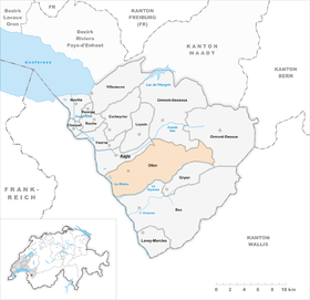
| Location of the municipality | |
  |
|
Ollon is a municipality in the Aigle district in the canton of Vaud in Switzerland . The former German name Olun is no longer used today.
geography


Ollon lies at 478 m above sea level. M. , 3 km southeast of the district capital Aigle (air line). The village extends on the debris cone of the Bondet brook at the foot of the slope on the eastern edge of the Rhone Valley, in a climatically protected south-facing slope at the foot of the forest hills of the Bois de la Glaive .
The area of the 59.6 km² municipal area covers a section of the Vaudois Alps. The vast area is bounded to the west by the Rhone . From here, the municipality extends eastward over the broad valley in which the isolated hill area of Saint-Triphon (in Charpigny 508 m above sea level ) rises. At the foot of the slope are the flat alluvial cone of the Gryonne , which always forms the southern border, and the debris cone of the Bondet .
The eastern part of the municipality extends into the Vaudois Alps and includes the Chamossaire ( 2112 m above sea level ) with the two mountain lakes Lac de Bretaye and Lac Noir . On the south side of this mountain is the arena of Villars-sur-Ollon and Chesières high above the valley of the Gryonne and the Rhône. North of Chamossaire is the valley of the Grande Eau , whose upper valley flank still belongs to Ollon. In a narrow corner, the area extends further east over the Chaux Ronde ( 2028 m above sea level ) and the Col de la Croix road pass to the rocky western flank of the Culan , which already belongs to the massif of Les Diablerets . On the rock face of the Culan is around 2200 m above sea level. M. reached the highest point of Ollon. In 1997, 9% of the municipal area was accounted for by settlements, 45% for forests and woodlands, 42% for agriculture and a little more than 4% was unproductive land.
Numerous hamlets, individual farms and alpine settlements belong to Ollon, including:
- Saint-Triphon , 429 m above sea level M. , in a hilly area in the Rhône Valley (430 inhabitants)
- Villy, 411 m above sea level M. , at the foot of the slope south of Ollon (205 inhabitants)
- Sala, 469 m above sea level M. , at the foot of the slope near the entrance to the Gryonne valley (52 inhabitants)
- Les Fontaines, 502 m above sea level M. , on the slope above Sala (54 inhabitants)
- Antagnes, 567 m above sea level M. , above the entrance to the Gryonne Valley (258 inhabitants)
- Glutières, 773 m above sea level M. , on the slope above Ollon (88 inhabitants)
- Forchex, 748 m above sea level M. , on the southern slope above the Gryonne valley (29 inhabitants)
- Auliens, 807 m above sea level M. , on the southern slope above the Gryonne valley (14 inhabitants)
- Paluaires, 765 m above sea level M. , on the southern slope above the Gryonne valley (23 inhabitants)
- Les Combes, 884 m above sea level M. , on the southern slope above the Gryonne valley (27 inhabitants)
- Huémoz, 1004 m above sea level M. , in a panoramic location high above the Rhône Valley (176 inhabitants)
- Les Ecovets, 1,300 m above sea level M. , in a saddle high above the Rhône Valley (38 inhabitants)
- Chesières, 1208 m above sea level M. , on the terrace above the Gryonne valley south of Chamossaire (1,373 inhabitants)
- Villars-sur-Ollon , 1253 m above sea level M. , on the terrace above the Gryonne valley south of Chamossaire (1438 inhabitants)
- Arveyes, 1231 m above sea level M. , on the southern slope of the Bois du Bilioley above the Gryonne valley (268 inhabitants)
- Verchiez, 543 m above sea level M. , in a saddle between the heights of Plantour and Bois de la Glaive (31 inhabitants)
- Plan d'Essert, 655 m above sea level M. , on the southern slope of the Bois de la Glaive (31 inhabitants)
- Panex, 935 m above sea level M. , on a ledge between the valleys of Grande Eau and Bondet (126 inhabitants)
- Plambuit, 1123 m above sea level M. , on a terrace above the valley of the Grande Eau (22 inhabitants)
- Bretaye, 1806 m above sea level M. , Alpine settlement on Lac de Bretaye, east of Chamossaire (23 inhabitants)
- Ensex, 1787 m above sea level M. , Alpine settlement on the southern slope of the Chaux Ronde
- La Croix, 1753 m above sea level M. , Alpine settlement near the Col de la Croix
Neighboring municipalities of Ollon are Bex , Gryon , Ormont-Dessus , Ormont-Dessous and Aigle in the canton of Vaud and Monthey and Collombey-Muraz in the canton of Valais .
population

With 7,463 inhabitants (as of December 31, 2018), Ollon is one of the larger municipalities in the canton of Vaud. 79.2% of the residents are French-speaking, 5.4% English-speaking and 3.9% German-speaking (as of 2000). The population of Ollon in 1900 was 3428 people. In the course of the 20th century the population increased slowly but steadily (4126 inhabitants in 1960). Only since 1980 (4429 inhabitants) has a significantly increased population growth been recorded.
economy
Until the end of the 19th century, Ollon was a predominantly agricultural village. From about 1840 the upper part of the municipality around Villars-sur-Ollon and Chesières developed into an important tourist destination.
Today Ollon offers around 2100 jobs. With 14% of the workforce still employed in the primary sector, agriculture still has a certain place in the employment structure of the population. Around 12% of the workforce is employed in the industrial sector, while the service sector accounts for 74% of the workforce (as of 2001).
Agriculture still shows great diversity thanks to the extensive municipal area and the different altitudes. There are extensive arable and fruit growing crops in the Rhône plain . On the perfectly sunny slopes at Ollon, Verchiez and Sala as well as at Saint-Triphon, viticulture is practiced on an area of around 140 hectares . Sweet chestnut forests thrive on the slopes above the vineyards . The higher elevations are used for dairy farming and cattle breeding . To the east of the Chamossaire and in the area of the Col de la Croix there are extensive alpine pastures for grazing livestock.
The industry is mainly located in the Rhône plain, but is not very well represented in Ollon compared to the neighboring communities. On the hills of Saint-Triphon, a black limestone was extracted in several quarries, which was widely used in western Switzerland for architectural purposes and is known under the name Marbre de St. Triphon . Many fountain basins, even in Bern, were made by stonemasons from this stone, which is one of the most important Swiss architectural materials. The companies are active in the construction and transport sector. Otherwise, in addition to meeting daily needs, the industry is mainly geared towards the needs of tourism. After 1990, test drillings were carried out near Ollon for a possible radioactive waste repository.
tourism
With the opening of the road from Ollon to Chesières in 1867, the rapid economic boom in Villars-sur-Ollon and Chesières through tourism began. Since then, numerous hotels, holiday apartments, weekend houses and sports centers (tennis, golf, ice rink) have been built. Today Villars and Chesières are among the most important winter sports resorts in the region. The surrounding heights are accessible by several mountain railways and the Villars-Bretaye cogwheel railway and ski lifts. The ski region of Villars-sur-Ollon is connected to that of Gryon by the railway line to Gryon and several ski lifts. Even during the summer, Villars is a popular place for relaxation and hiking for day tourists.
traffic
The community is very well developed in terms of transport. It is located near the main road 9 , which leads from Lausanne via Sion to the Simplon Pass . From this road branches off at Ollon the road to Villars-sur-Ollon. The next motorway junction to the A9 (Lausanne – Sion), which opened in 1970 and crosses the municipality, is around 3 km from the town center.
On June 10, 1857, the Villeneuve - Bex section of the railway line from Lausanne to Sion was inaugurated with the Saint-Triphon Gare station. Three private railways, which are now operated by the Transports Publics du Chablais , touch the municipality of Ollon: the Chemin de fer Aigle-Ollon-Monthey-Champéry (since April 2, 1907), the Chemin de fer Aigle-Sépey-Diablerets (since December 22, 1913; with stops at Verchiez, Plambuit and Exergillod) and the Chemin de fer Bex-Villars-Bretaye . The Gryon - Villars-sur-Ollon section was put into operation on June 10, 1901, and the extension to La Bretaye opened in 1913.
Bus routes from Aigle via Ollon to Villars-sur-Ollon and from Ollon to Plambuit take care of the fine distribution in public transport.
history
The municipality of Ollon was settled very early. Grave fields from the Bronze Age and the Iron Age have been discovered in the Rhone Valley . During the Roman period , the important trade route from Aventicum (Avenches) to Octodurum (Martigny) crossed the area. There are also remains from this period.
The place was first mentioned in a document in 516, when King Sigismund of Burgundy donated what was then the aulonum to the newly founded Abbey of Saint-Maurice . The place names Olonum , Oluns and the patois form Ulon appeared later .
Ollon has been part of the abbey since it was first mentioned. In the 13th century it gradually came under the influence of the Counts of Savoy. With the conquest of Aigle by Bern in 1476, Ollon came under the administration of the Aigle governorate , but always formed its own mandement. After the collapse of the Ancien Régime , the village belonged to the canton of Léman from 1798 to 1803 during the Helvetic Republic , which then became part of the canton of Vaud when the mediation constitution came into force . In 1798 it was assigned to the Aigle district.
At the beginning of the 19th century, the high parts of the municipality (around Huémoz, which for a long time was the most important mountain village above Ollon) sought political independence. However, this undertaking was not approved by the Vaudois Grand Council. Salt mines were discovered at Panex as early as the 16th century and the deposits were exploited with the first Swiss salt works (abandoned in 1832). With the improved transport connections, Villars-sur-Ollon and Chesières developed into important tourist destinations in the second half of the 19th century.
coat of arms
Description : A common silver cross is square on green and red .
Attractions
The wine-growing village of Ollon has a picturesque townscape with numerous well-preserved wine-growing houses from the 17th to 19th centuries. The present Reformed Church of Saint-Victor, mentioned in 1244, was owned by the Saint-Maurice Abbey. The church was given its current shape when it was rebuilt in the 15th century and when it was redesigned in the 17th century. In the choir there is a frieze from the 15th century depicting the apostles.
In the center of the town is the Hôtel de Ville (town hall) from 1722 with a massive Bern roof. The castle with the name Château de La Roche has been mentioned since 1386, but presumably already existed at the end of the 12th century. It has a small round tower and was extensively restored in the 16th century.
The Maison des Salins is in Panex. A tunnel and a burning building are still preserved from the former salt mine.
In the district of Saint-Triphon, whose small village center lies on a limestone hill in the flat area of the Rhone plain, there is a private and publicly accessible botanical garden (Jardin Botanique). This garden complex shows alpine and Mediterranean plant communities and has a small succulent house and a specialist library. The garden, including its scientific inventory, is owned by William Aviolat , who lives there and maintains the facility on a daily basis.

Rectory and Church of St-Victor

Village center

Catholic Church

Train composition of tpc in the station

Collège de Perrossale

Les Verschy sports center

View to St-Triphon

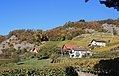
Vineyards near Ollon
Ollon Verchiez


Personalities
- Jacques Chamorel (1901–1962), lawyer and politician (LDP)
- Ruth Niehaus (1925–1994), actress
- Frédéric Rouge (1867–1950), painter
Web links
- Official website of the municipality of Ollon (French)
- Emmanuel Abetel et al. a .: Ollon. In: Historical Lexicon of Switzerland .
- François Berger: Saint-Triphon. In: Historical Lexicon of Switzerland .
- Website of the tourist region Villars-Gryon
- Castle website: Château de la Roche (French)
- Aerial views of the village
Individual evidence
- ↑ Permanent and non-permanent resident population by year, canton, district, municipality, population type and gender (permanent resident population). In: bfs. admin.ch . Federal Statistical Office (FSO), August 31, 2019, accessed on December 22, 2019 .
- ↑ Demandeurs d'emploi, chômeurs et taux de chômage par commune. ( XLS , 115 kB) Statistique Vaud, Département des finances et des relations extérieures (Statistics Vaud, Department of Finance and Foreign Affairs), accessed on June 14, 2015 (French).
- ^ Michel Septfontaine: Belles et utiles pierres de chez nous. Lausanne 1999, pp. 21-22
- ↑ The Botanical Garden of St-Triphon. St-Triphon, accessed May 4, 2016 .
Aigle | Bex | Chessel | Corbeyrier | Gryon | Lavey-Morcles | Leysin | Noville | Ollon | Ormont lingerie | Ormont-Dessus | Rennaz | Roche (VD) | Villeneuve (VD) | Yvorne
Former parishes: Lavey | Morcles
Canton of Vaud | Districts of the canton of Vaud | Municipalities of the canton of Vaud