Ondara
| Ondara municipality | ||
|---|---|---|
 Plaça del Convent
|
||
| coat of arms | Map of Spain | |

|
|
|
| Basic data | ||
| Autonomous Community : | Valencia | |
| Province : | Alicante | |
| Comarca : | Marina Alta | |
| Coordinates | 38 ° 50 ′ N , 0 ° 1 ′ E | |
| Height : | 36 msnm | |
| Area : | 10.41 km² | |
| Residents : | 6,894 (Jan 1, 2019) | |
| Population density : | 662.25 inhabitants / km² | |
| Postal code : | E-03760 | |
| Municipality number ( INE ): | 03095 | |
| administration | ||
| Official language : | Castilian , Valencian | |
| Mayor : | José Joaquín Ferrando Soler ( PP ) (2009) | |
| Website : | www.ondara.org | |
| Location of the municipality | ||
 
|
||
Ondara is a small town in the province of Alicante in Spain .
The city was built by the Moors . Jacob I (Aragón) incorporated the city into the Kingdom of Valencia in 1244 , which belonged to the Crown of Aragon .
Worth seeing
The typical Arab construction of the houses and streets can still be seen today. Are worth seeing
- the town hall built in the 17th century,
- the bullring renovated in 1957 ,
- two churches from the 16th and 17th centuries
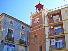
- the Torre del Relotge (clock tower), the only remnant of the originally four-towered Moorish castle and
- a 150 year old well.
The patron saint of Ondaras is the Virgen de la Soledad (Virgin of Solitude).
Web links
Commons : Ondara - collection of images, videos and audio files
Individual evidence
- ↑ Cifras oficiales de población resultantes de la revisión del Padrón municipal a 1 de enero . Population statistics from the Instituto Nacional de Estadística (population update).

