
Oppenberg (Rottenmann municipality)
|
Oppenberg ( scattered houses ) locality cadastral municipality Oppenberg |
|||
|---|---|---|---|
|
|||
| Basic data | |||
| Pole. District , state | Liezen (LI), Styria | ||
| Judicial district | Liezen | ||
| Pole. local community | Rottenmann | ||
| Coordinates | 47 ° 29 '16 " N , 14 ° 16' 27" E | ||
| height | 1006 m above sea level A. | ||
| Residents of the village | 239 (January 1, 2020) | ||
| Building status | 105 (2001) | ||
| Area d. KG | 92.81 km² | ||
| Post Code | 8786 | ||
| Statistical identification | |||
| Locality code | 15830 | ||
| Cadastral parish number | 67510 | ||
| Counting district / district | Oppenberg (61263 005) | ||
 Oppenberg rectory and parish church |
|||
| Source: STAT : index of places ; BEV : GEONAM ; GIS-Stmk | |||

Oppenberg is a former municipality with 238 inhabitants (as of October 31, 2013) in Styria in the judicial district or district of Liezen . As part of the structural reform of the Styrian community , it was merged with the Rottenmann community at the beginning of 2015 , and the new community continues to use the name Rottenmann Municipality. The basis for this is the Styrian Municipal Structural Reform Act - StGsrG.
geography
Oppenberg is located with two side valleys at about 1000 meters above sea level in the Liezen district in the Austrian state of Styria . The surrounding mountains are the Blosen, Hochgrössen and the Schüttkogel.
The Gulling , which flows through the Gullingtal and then flows into the Enns north of Aigen im Ennstal, rises in the former municipality of Oppenberg .
There were no other cadastral communities apart from Oppenberg.
history
The Church of the Birth of Mary with the famous anonymous surgery painting from the 18th century dates from the 12th century. In the Middle Ages gold, silver and copper mining was carried out here. The Rottenmann Augustinian Canons' monastery had held the mountain shelf for all mountain finds in this area since 1463. The abolition of the manorial lords took place in 1848. The local community as an autonomous body was established in 1850. After the annexation of Austria in 1938, the community came to the Reichsgau Steiermark, 1945 to 1955 it was part of the British zone of occupation in Austria.
Culture and sights
See also: List of listed objects in Rottenmann
- Pilgrimage church of the “Nativity of Mary” from the 12th century with the Dreikönigsschrein (crib shrine) by Erasmus Grasser from 1480.
- Calvary
- Jagdgut "in der Strechen", formerly built by Max von Gutmann , now owned by the Flick Private Foundation .

Catholic parish church of the Birth of Mary and cemetery
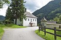
Vicarage (Oppenberg 46)
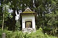
6. Wayside shrine on the Oppenberg processional path


politics
Mayor was Franz Schrattenthaler (OVL). The municipal council was composed as follows (after the 2010 elections): 6 Oppenberger Volksliste, 2 ÖVP , 1 SPÖ
coat of arms
The municipal
coat of arms was awarded with effect from August 1, 1994.
Description of coat of arms: In blue, a twelve-rayed faceted golden star with three elongated rays, surrounded by three (1: 2) outwardly swept golden canopy.
Personalities
Honorary citizen
- 1985 Josef Krainer (1930–2016), governor
Individual evidence
- ↑ State of Styria: Final population status on October 31, 2013 ( Memento of the original from April 15, 2015 in the Internet Archive ) Info: The archive link was inserted automatically and has not yet been checked. Please check the original and archive link according to the instructions and then remove this notice. (Excel file, 85 KB; accessed May 2, 2015)
- ^ Styrian municipal structural reform .
- ↑ Section 3, Paragraph 6, Item 4 of the law of December 17, 2013 on the restructuring of the municipalities of the State of Styria ( Styrian Municipal Reform Act - StGsrG). Provincial Law Gazette for Styria of April 2, 2014. No. 31, year 2014. ZDB -ID 705127-x . P. 3.
- ^ Announcements from the Styrian State Archives 47, 1997, p. 38
Web links
- 61229 - Oppenberg (Rottenmann municipality). Community data, Statistics Austria .

Bärndorf | Boder | Bruckmühl | Büschendorf | Edlach | Klamm | Oppenberg | City of Rottenmann | Sankt Georgen | Singsdorf | Strechau | Stretching | Villmannsdorf