Pěnkavčí vrch
| Pěnkavčí vrch | ||
|---|---|---|
|
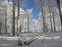
Pěnkavčí vrch from the south |
||
| height | 792 m nm | |
| location | Czech Republic | |
| Mountains | Lusatian Mountains | |
| Dominance | 2.5 km → Listen | |
| Coordinates | 50 ° 50 '54 " N , 14 ° 36' 39" E | |
|
|
||
| rock | Phonolite | |
Pěnkavčí vrch (German Finkenkoppe , also Finkenkuppe ) is the second highest mountain of the Lusatian Mountains in the Czech Republic with 792 m nm .
Location and surroundings
The massive phonoly elevation is located 2.5 km west of the Lausche ( 793 m , Czech: Luž ) and is covered by a high beech forest. Over the hill that runs watershed between the basins of the Elbe and Oder , the northern and western springs and streams carry their water to Lausur and Mandau , while inflows to Hamerský Potok (Hammersbach) and Boberský Potok (Bober Bach) over the Svitávka (Zwittebach) and Ploučnice (Polzen) drain to the Elbe.
To the north of the Finkenkoppe, separated by the Milířka ( Kohlhaubach ) valley , about one and a half kilometers away is the Weberberg ( 711 m ), over which the German-Czech border runs. The Hamerský potok (Hammerbach) forms the natural border in the east. Located to the west of the Valley Lesenský brook ( Goldflössel ) and the Míšeňský dul ( Meißen base ) separates the Finke Koppe from the solid from which Jedlova ( Tannenberg ) and Tolštejn ( Tollenstein ) protrude. Southwestern, at the origin of Goldflössels, is located opposite the comb Jelení kameny ( Hirschstein ) in 605 m of Stožecké sedlo ( Schöberpass ), via which the built 1794-1797 road Rumburk according Česká Lípa leads. South of the Pěnkavčí vrch rises the cone of the 702.5 m high Bouřný ( Friedrichsberg ). The foremost row of bunkers on the Schöberlinie , a section of the Czechoslovak state fortifications built in 1937, runs through the pass between them, which was constructed in two rows in a lightweight design.
Development
The touristic development of the mountain came late. Along the historical border between the Reichstadt and Rumburg dominions , which still separates the Okres Děčín from the Okres Česká Lípa today , a paved hiking trail was laid from 1907 from Vogelherd (Ptačinec) to Schöbersattel ( Stožecké sedlo ) and in 1909 A refuge was built on the summit, which collapsed in 1925. Later, the hiking trail was led around the summit to the west due to the high tree cover only severely restricted view options. Along the old route there are still individual boundary stones from 1704 and 1750.
particularities
Ptačinec
The Ptačinec (Vogelherd) is the northernmost branch of the Pěnkavčí vrch. The elevation ( 679 m nm ) is 2.5 kilometers west of Waltersdorf near the German-Czech border. A connection path once led from the Kohlhaugrund (Milířky údolí) near Innozenzidorf (Lesné) to the Eisgasse and Waltersdorf via the Černá brána (Black Gate) saddle below the bird herd to the Weberberg .
A quartzite rock standing directly on the border bears the designation Dreiecker (Trojhran). On the 673 m high rock, the border leading from the east on the ridge of the Lusatian Mountains turns out of the mountains out to the north in the direction of Dolní Podluží (Niedergrund) and Varnsdorf (Warnsdorf) in the North Bohemian Netherlands . In addition to a granite modern boundary stone attached to the rock, old boundary signs and several dates from the period from 1653 to 1783 are carved into the rock. A device fitted in German territory panel explained that the rock the triangle between the dominions Rumburg (R), Reich city (RE) and the common image of the city Zittau (Z) showed.
On the western slope of the bird herd there are the Vrabčí kámen (sparrows), two free-standing quartzite rocks that are used as easy climbing rocks and are also known as Babice.
Western slope
Several rock formations can be found on the western slope of the Finkenkoppe. Below the Na milíři hunting lodge at the transition to the sandstone surface of the Devil's Plan (Čertova pláň), the Jezevčí kámen (badger stone) located above the Jezevčí důl is worth mentioning.
Further south towards the valley of the Lesenský potok (Goldflössel) follow the basalt rocks of the Klapáč (Powder Schöber , 635 m ), Granát (Granatenschöber, 680 m ) and Pětikostelní kámen (Fünfkirchenstein, 689 m ). The latter takes its name from the fact that five church towers should be visible from its view to the northwest. The westernmost foothill is the Smrčec (Fichtenschöber, 630 m ) on the Schöber Pass ( Stožecké sedlo ).
literature
- Jiří Švécar: Nejsevernější Čechy - The northernmost Bohemia , self-published, 1995
- Andreas Bültemeier: Hikes in the Lusatian Mountains and the Bohemian Netherlands , Oberlausitzer Verlag, Spitzkunnersdorf, 2003; ISBN 3-933827-29-9 .


