
Parey (Elbe-Parey)
|
Parey
Unified municipality Elbe-Parey
|
|
|---|---|
.png) |
|
| Height : | 40 m above sea level NHN |
| Area : | 21.93 km² |
| Residents : | 2094 (December 31, 2018) |
| Population density : | 95 inhabitants / km² |
| Incorporation : | September 1, 2001 |
| Postal code : | 39317 |
| Area code : | 039349 |
Parey is a district of the Elbe-Parey community in the Jerichower Land district in Saxony-Anhalt .
geography
Parey is the administrative and geographical center of the unitary municipality Elbe-Parey, which is located in the northeast of Saxony-Anhalt. Parey is surrounded on three sides by waterways. The place is located directly on the west bank of the Elbe-Havel Canal , three kilometers to the west the Elbe flows past. Both are connected north of Parey by the Pareyer connecting canal and the Parey lock . On the southern outskirts there is a 2 km² forest area. The Middle Elbe Elbe Landscape Biosphere Reserve extends towards the Elbe. State road 54 runs through the village and connects Parey with its neighboring towns of Derben in the north and Güsen in the south. The distance to the district town of Burg is 21 kilometers. In addition to the residential areas of the settlement and western colony, which face west, the town center has an area of 1.3 km² and is 40 meters above sea level.
history
In connection with the establishment of the Diocese of Brandenburg, King Otto I's deed of foundation mentioned the forest “porei with the villages that have been built and are still being built”. The year of the document fluctuates between 946 and 948. However, archaeological finds have shown that the Pareyer valley sand island (see also Elbe-Urstromtal ) was inhabited in earlier times. At the time of the Slavic settlement in the 5th and 6th centuries, the Pareyer area belonged to the Untergau Semcici.
From the 10th century on, Parey was closely linked to the von Plotho noble family . This bond is still evident today in the Pareyer coat of arms, in which the Plotho lily is depicted. Already in 946 there was a Plothosches castle estate in Parey. After August 10, 1434, the cities of Magdeburg and probably also Zerbst besieged and stormed Parey Castle, as they both besieged and captured Jerichow and Plotho Castle (Altenplatow) afterwards. In 1435 Parey had to be returned. However, the Plothos feud with Zerbst did not end until 1438 with an arbitration award. In the course of further history, the castle and the place were destroyed by a flood of the Elbe in 1499, the inhabitants settled in another place, which corresponds to the current location. Between 1521 and 1525 the castle and village were fiefdoms of the Havelberg diocese.
From 1655 at the latest, the Plotho property was divided into two manors, each of which had its own castle. The larger estate I owned 750 hectares of land. In 1698 Werner von Plotho donated a richly furnished church to the village. The Brandenburg state servant Ludwig Otto von Plotho is known as the owner of Gut II around 1700 . At this time, Parey was already under Brandenburg state sovereignty. The next higher administrative unit was the entire district of Jerichow, from which the district of Jerichow II (1818) with the district town of Genthin developed over the district of Jerichow II (1785) . In a fire in 1736 the larger Renaissance style castle was destroyed and later replaced by a simpler baroque building. In 1800 the von Plotho family lost the manor II due to unclear feudal relationships. Until the 19th century, Parey was the seat of a postal expedition , where the stagecoach could change horses.

At the instigation of the Prussian King Friedrich II, the construction of the Plauer Canal began in 1743, from which the Elbe-Havel Canal later emerged in connection with the Ihle Canal. The canal flowed into the Elbe north of Parey, and the wooden old Parey lock was installed at Parey, which was south of the canal, to regulate the gradient . In connection with industrialization in the first half of the 19th century, a lignite seam was discovered during earth bores in the Pareyer area, which, however, like most of the other deposits found in the Jerichower Land, was not mined. Rather, the abundant clay deposits were used by brick factories, 16 of which have settled near Parey over the years.
In 1890 a ship school was founded in Parey. In the years from 1888 to 1892 the Elbe was re-diked near Parey and in this context a new breakthrough was created between the Elbe and Plauer Canal. The Parey lock was converted into a new two-chamber composite system. In 1922, the Köster sawmill built an electrically operated cable crane for mechanically loading and unloading the wooden carts. Because of its construction, which is unique in Germany, the facility was later placed under monument protection.
Until the beginning of the Second World War, Parey's economic structure was largely determined by the brick making, shipping and wood processing, in addition to agriculture. The number of brickworks had already declined sharply at the beginning of the 20th century, but with Hoffmann's ring kiln brickwork, a modern and high-performance company was established in 1888, which continued to produce until 1978. About 220 pareyers were employed in the shipping industry around 1920. With the opening of the Güsen – Jerichow railway line in 1924, Parey had its own station. A concrete plant started operations in the 1930s. With the extension of the Elbe-Havel Canal, the waterway led directly past Parey from 1938. The number of inhabitants had risen to 2945 in 1939.
On September 30, 1928, the manor district of Parey on the Elbe (at the end of the 19th century there were still two manor districts) was united with the rural community of Parey. In the official gazette of the administrative district of Magdeburg in 1935 the "formation of pension goods from the Rittergute 1 Parey" was announced.
After the Second World War, Plotho's goods were expropriated and the land was distributed to smallholders. The Pareyer industrial companies were nationalized as "nationally owned". The Plotho Castle was transferred to the local community, which initially housed public facilities there, but had it demolished in 1951 due to excessive maintenance costs. The Parey steel construction was created from the former concrete plant, and with 750 employees, it has become the largest employer in the area. As a result of the first administrative reform in the GDR, Parey was incorporated into the Genthin district. In 1964 the population was 3,030. In 1970 a Catholic chapel was consecrated on the main street, which was abandoned in 2010 and has since been demolished.
After the reunification of Germany in 1990, mainly the economic structure changed in Parey. As before, the steel u. Lattice mast construction is the largest operation, alongside a gravel plant and a branch of the screw and wire union form the industrial core (status 2007). An assembly and loading system with a lifting device for 500-tonne loads and a 35-meter-long cantilever arm was built on the Elbe-Havel Canal. In 1999 passenger traffic on the Güsen – Jerichow railway line was discontinued. After the formation of the Elbe-Parey community on September 1, 2001, Parey became the administrative center and location of the central secondary school.
politics
The Parey local council consists of nine members.
Local mayor is Cora Schröder (CDU).
coat of arms
The coat of arms was approved on June 28, 1995 by the Magdeburg Regional Council.

Blazon : "In silver three (1: 2) red lilies."
The symbolism is based on the coat of arms of the Barons von Plotho. This is justified because the fate of Parey and its citizens was decisively influenced by the noble house of Plotho in earlier times. The heraldic symbol of the Bourbon lily is borrowed from Plotho's coat of arms.
Historical coat of arms
The former municipality of Parey already had a coat of arms-like seal image in its municipality seal. This was used in the period after the Second World War until around the introduction of the districts and counties in the GDR (1945–1952). Another source is the County Home Museum in Genthin.
Culture and sights
- The Soviet Memorial for Red Army soldiers , plus the graves for two Polish women known by name and two unknown Soviet citizens who were abducted to Germany during the Second World War and were victims of forced labor , as well as for four Germans who died.
- The Holy Trinity Church was built between 1697 and 1698 on a hill in the village. The family crypt of those of Plotho is located in their rooms.
- The Hoffmann ring furnace , built in 1885, has 20 combustion chambers and was built according to the original patent by Hoffmann und Licht.
- The wooden cable crane system was built in 1922 from the former sawmill and is unique in Germany with a cable haulage of 120 meters.
- The two-chamber lock at Parey from 1892 connects the Elbe-Havel Canal with the Elbe.
- The Parey windmill was built as a Paltrock windmill and is now a monument.

Pareyer lock
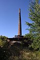
Technical monument ring furnace
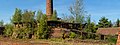
Ring kiln with loading ramp

Evangelical Trinity Church
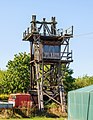
Pylon with steering position

Wooden pylon

Nutria in the Herrenseegraben


Personalities
- Erich Christoph Edler Herr and Freiherr von Plotho (1707–1788), Prussian politician
- Thassilo Krug von Nidda (1814–1871), Prussian major general
- Wilfried Hilgert (1933–2016), entrepreneur and chess patron
Web links
Individual evidence
- ↑ above: Magdeburg Schöppenchronik (Chronicles of the cities of Lower Saxony 7, Magdeburg) . Ed .: Historical Commission at the Royal Academy of Sciences. Leipzig 1869, p. 380 .
- ^ Washke, Hermann: Regesta and documents of the Ducal House and State Archives in Zerbst in the years 1401–1500 . Dessau 1909, p. No. 305 .
- ↑ Administrative region of Magdeburg (Ed.): Official Gazette of the Government of Magdeburg . 1928, ZDB -ID 3766-7 , p. 224 .
- ↑ Administrative region of Magdeburg (Ed.): Official Gazette of the Government of Magdeburg . 1935, ZDB -ID 3766-7 , p. 147 .
- ^ Catholic chapel on the website of the parish Genthin
- ↑ StBA: Changes in the municipalities in Germany, see 2001
- ^ Parey local council