
Ferchland
|
Ferchland
Unified municipality Elbe-Parey
|
|
|---|---|
 |
|
| Height : | 38 m above sea level NHN |
| Area : | 12.02 km² |
| Residents : | 563 (December 31, 2018) |
| Population density : | 47 inhabitants / km² |
| Incorporation : | September 1, 2001 |
| Postal code : | 39317 |
| Area code : | 039349 |

Ferchland is part of the Elbe-Parey community in the Jerichower Land district in Saxony-Anhalt .
geography
The village of Ferchland is located on the east bank of the Elbe . While the Ferchlander steep bank of the Elbe on Galgenberg reaches a height of 61.8 meters above sea level, the terrain drops to 35 meters in the east to the neighboring town of Nielebock . A narrow strip of agricultural land is bordered by forest to the north and south. The elevation of the Galgenberg continues in the south as Derbenscher Berg.
The district road 1196 runs through Ferchland, which had crossed the Elbe by means of the Ferchland-Grieben ferry until June 2020 and connects to the neighboring town of Nielebock in the east. You can reach Klietznick in the north and Derben in the south via Landesstraße 54, which runs north-south through the town . The administrative center of the unified municipality in Parey is seven kilometers away, and the district town of Burg is 26 kilometers away.
history
Already 4600 years ago in the Stone Age people lived in the area of today's Ferchland, as archaeological finds have proven. Remnants of Slavic and Germanic settlements were also found. Linguists also attribute Slavic and Germanic origins to the place name. The first syllable is said to be derived from the Slavic “vruchu” summit, while “land” can be clearly assigned to the German-speaking area. A document dated December 4, 1302 speaks of a place "Verchlande", in which Gerhard von Plotho concludes a contract on forest use with the Jerichow Monastery . It was the first written mention of Ferchland.
On the basis of broken fragments it can be assumed that there was already a street that was inhabited on both sides by the middle of the 12th century. Another document from 1376 mentions two knight seats, one owned by the von Rauneberg family, the other owned by Henning von Barby. In 1435 the families von Redekin and von Clöden are mentioned as owners of the manor. In 1559 there is talk of a knight von Randau who messed with the city of Magdeburg because of his raids . An order by the Archbishop of Magdeburg, Siegmund, about the taxes to be paid to the church around 1560 names two manors and 29 landlords.

_IMG_8892.jpg)
An Elbe ferry was mentioned for the first time in 1722, and in 1729 the old church, which had previously stood on the banks of the Elbe, was replaced by a new building at what was then the northeastern exit of the village. According to written records, there is said to have been a fire brigade in Ferchland as early as 1754, and in 1783 the local chronicle reports numerous deaths in small children from smallpox , typhus and dysentery . When Prussia reorganized its territorial administration after the Congress of Vienna , Ferchland was incorporated into the Jerichow II district with the district town of Genthin .
On May 17 and 18, 1813, Lützow marched with three squadrons of his squad to Ferchland and crossed the Elbe here to reach Stendal.
In 1820 there was a royal forester's house, a ferry house, two jugs, two windmills and a ship mill in Ferchland , the 333 inhabitants lived in 59 houses.
At Elbe kilometer 374.85, the Ferchländer level was set up on the right bank of the Elbe in 1874 and was read daily until 1963. From November 1, 1935, the level zero point was lowered by one meter from 30.91 meters to 29.91 meters + NN . The lower part of the Ferchländer level consists of seven visible hewn sandstone blocks. On the side facing the Elbe, an iron level lath is attached, in which the 2-centimeter scale made of porcelain and the numbers are embedded.
At the beginning of the 20th century the place had about 760 inhabitants. The founding of the “Deutsches Haus” craft association in 1902 indicates that this guild has a strong presence. The Güsen – Jerichow railway line, completed in 1925, with its “Ferchland” station did not result in any significant structural changes, especially as it passed the site at some distance.
On September 30, 1928, the Ferchland manor district was united with the rural community of Ferchland.
The plan of the Economic Research Association Berlin to set up a fuel store in Ferchland brought about major changes . In preparation for this, a housing estate was built on the Galgenberg in 1935.
With the beginning of the Second World War in 1939, the large tank farm (WIFO) began operations. It was bombed by the US 8th Air Force on January 14, 1945. On April 29, an exchange of prisoners took place at the Ferchländer ferry station between the Wenck Army fighting in the Elbe bridgehead area and the 9th US Army . On May 3rd and 4th, surrender negotiations between officers of the Wenck Army and the US Army took place in the Stendal town hall . Until May 7th, thousands of soldiers and refugees in Ferchland around Fischbeck and north of Schönhausen crossed the Elbe in the already reduced bridgehead area. On May 7, 1945 around 5 p.m., Panzer General Walther Wenck crossed the Elbe with his chief of staff and some officers near Ferchland and was taken prisoner by the Americans. On May 8th, thousands of German soldiers who were already in American captivity were handed over to the Soviet troops at the Ferchland ferry station.
After the Second World War, the land reform ordered by the Soviet occupation forces expropriated the manors and the property was divided among 66 smallholders. They were transferred to cooperative management in the 1950s. The ferry traffic was stopped and the connection to the western bank of the Elbe was interrupted. When the GDR carried out a regional reform in 1952, Ferchland came to the Genthin district . In 1957, a Catholic chapel was inaugurated in the hall of a restaurant on the corner of Hauptstrasse and Elbstrasse, which was abandoned in 1991. In 1964 1041 people lived in the village.
The time after German reunification was initially characterized by structural renovation, such as the installation of a central sewage network. On April 4, 1998, ferry traffic was resumed after an interruption of almost 50 years. Several small businesses, a large wood processing company and an animal production cooperative were established. In addition, with the establishment of a larger tourist station, the prerequisites for tourism were created. On the occasion of the 700th anniversary, a wind farm was put into operation on June 8, 2002 . On September 1, 2001, Ferchland joined forces with other communities to form the Elbe-Parey community.
politics
The Ferchland local council consists of five members.
The local mayor is Otto Schmidt (WGFE).
coat of arms

Old seal of the community of Ferchland from 1927
Old seal of the Ferchland community from 1949


|
|
Blazon : "In silver, three red fish on stakes, the top and bottom turned to the left."
The municipality of Ferchland decided on April 21, 1998 to include the previously used symbolism of fish in the new coat of arms. In order to clearly distinguish itself from the coat of arms of the municipality of Derben, which has long been associated with Ferchland with fishing and ferry rights, the fish in the coat of arms of Ferchland were arranged in mirror image and tinged differently. The coat of arms was designed by the Magdeburg municipal heraldist Jörg Mantzsch and led to the approval process in 1998. |
| Justification for the coat of arms: Ferchland has used three fish in the image seal since the 18th century. These fish refer to the former abundance of fish on the Elbe, on which Ferchland is located with its historic and now re-established ferry. Since the fish identify themselves with the so-called adipose fin , it is evidently a reference to the salmon . The fish pointing in both directions also indicate the migration of salmon in its coming and going. |
Historical coat of arms
The former community of Ferchland already had a coat of arms-like seal image in its community seal. This was used in the period after the Second World War until about the introduction of the districts and counties in the GDR (1945–1952).
Another source is the County Home Museum in Genthin.
Culture and sights

- The Ferchland – Grieben ferry connecting the towns of Ferchland and Grieben across the Elbe was able to start operating from 1998 to June 2020.
- The Ferchland village church, built between 1729–1730 as a half-timbered cross church , is now in the center of the village. The church tower had to be demolished in 1935 down to the massive base and rebuilt according to the specifications of the monument protection authority in the height and shape of the old half-timbered tower.
- The previous Romanesque church, probably from the 12th or 13th century, used to be on the banks of the Elbe and had to be demolished because of the threat of collapse.
- Two memorial stones on the church square remember all the villagers who perished in the First and Second World Wars .
- In front of the church is the peace oak from 1871.
- You have a wide view of the Elbe from the Galgenberg near the ferry, which rises more than 30 meters (61.8 meters above sea level) over the Elbe on the steep bank.
- A Dutch steam mill from 1892 is now shut down and has no blades. It was last powered by electricity.
- In front of the former ferry house is the stick anchor from the 18th century, which used to hold a ship's mill in its position in the Elbe.
- Picture gallery
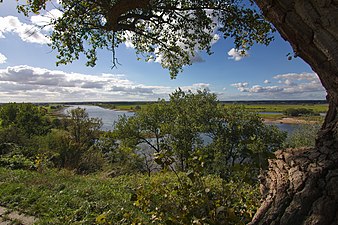
View from Galgenberg to the Elbe

Old tower dutchman

Memorial stone

War memorial

Information board Ferchland 1696
_IMG_8952.jpg)
_IMG_8918.jpg)


swell
- CD Saxony-Anhalt - Official Topographic Maps, State Office for Land Surveying and Geoinformation, 2003.
literature
- Horst Wedau: My home in the Jerichower Land. Ferchland in old pictures and reports. Ferchland 2016.
Web links
Individual evidence
- ↑ Port city on the "Blue Ribbon" - the Magdeburg Elbe Shipping, Tangermünde Local History Museum, Havel Shipping under sail, The Elbe near Ferchland v. Paul Ahlemann, village chronicle
- ^ Geographical map by Dr. Aribert Kampe
- ↑ "Right and left of the Kleinbahn in Bismarcklande", 1926, page 19
- ↑ Administrative region of Magdeburg (Ed.): Official Gazette of the Government of Magdeburg . 1928, ZDB -ID 3766-7 , p. 223 .
- ↑ Volksstimme of May 8, 2018, Genthiner Rundblick page 19
- ^ Catholic chapel on the website of the parish Genthin
- ↑ StBA: Changes in the municipalities in Germany, see 2001
- ↑ Ferry Ferchland-Grieben ( Memento from September 24, 2015 in the Internet Archive )
- ↑ Churches in Jerichower Land, page 37, Ferchland village church
- ↑ Ferchland village church on Tourist Information
- ↑ Genthiner Wochenblatt v. 1935, Volksstimme of August 6, 2014, family knowledge
- ↑ Village chronicle and state main archive Saxony-Anhalt, Dept. Magdeburg, A 9c XI War and Domain Chamber of Magdeburg. Office Derben mit Ferchland, No. 28, Bl. 171.
- ↑ World War Victims at www.volksstimme.de
- ↑ Info on Galgenberg on the Ferchland page of the municipality