Peace Arch Park
|
Peace Arch Provincial Park
|
||
|
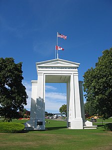
The Peace Arch as seen from the south side |
||
| location | British Columbia (Canada); Washington (USA) | |
| surface | 8.1 ha | |
| WDPA ID | 65351 | |
| Geographical location | 49 ° 0 ′ N , 122 ° 45 ′ W | |
|
|
||
| Setup date | Nov 7, 1939 | |
| administration | BC parks | |
The Peace Arch Park is located on the border between the US state of Washington and the Canadian province of British Columbia , directly at the western end of the transcontinental mainland border of the two states. Since it is a park that extends across borders, it is counted among the Peace Parks .
The park consists of Peace Arch State Park, which covers 9 acres on the United States side and Peace Arch Provincial Park, which covers 8.1 acres on the Canadian side. The park is named after the Peace Arch built in 1921 .
The park is a category II protected area ( national park ).
See also
Web links
Commons : Peace Arch Park - collection of pictures, videos and audio files
- Peace Arch Park . In: BC Geographical Names (English)
- Peace Arch Park . In: English language website of the park at BC Parks
- Peace Arch Park in the Geographic Names Information System of the United States Geological Survey
- Peace Arch State Park In: English language park website at Washington State Parks and Recreation Commission
- Entry in the Washington encyclopedia HistoryLink (English)

