Petite-Île (Municipality)
| Petite-Île | |
|---|---|

|

|
| region | Reunion |
| Department | Reunion |
| Arrondissement | Saint-Pierre |
| Canton | Saint-Pierre-3 |
| Community association | Villes Solidaires |
| Coordinates | 21 ° 20 ′ S , 55 ° 34 ′ E |
| height | 0-1,518 m |
| surface | 33.93 km 2 |
| Residents | 12,162 (January 1, 2017) |
| Population density | 358 inhabitants / km 2 |
| Post Code | 97429 |
| INSEE code | 97405 |
| Website | www.petite-ile.re |
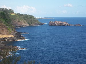
 The coast of Petite-Île |
|
Petite-Île (in German: Small Island ) is a French commune in the overseas department of Réunion with 12,162 inhabitants (January 1, 2017).
geography
The municipality is located in the south of Réunion, on the slopes of the Piton de la Fournaise volcano and borders the municipalities of Saint-Joseph and Saint-Pierre . It got its name after the upstream Petite Île ( German small island ).
history
In 1727 the economic use of what was later to become the municipality began: Governor Antoine Boucher granted several citizens from the municipality and then the island's capital Saint-Paul concessions for the cultivation of coffee, fruit and vegetables.
- 1735 - 35 households are registered in the municipality
- 1816 - 110 inhabitants
- 1857 - founding of the parish
- 1883 - first paved road to St. Pierre
- 1935 - church planting
- 1954 - Connection to the power grid
Education
There is a college in the municipality .
Economy and tourism
The community is dominated by agriculture. The main production goods are sugar cane, perfume plants, citrus fruits and vegetables.
There are numerous tourist guest houses in the village and a four-star hotel complex on the beach at Grande-Anse.


