Pliessnitz
| Pliessnitz | ||
|
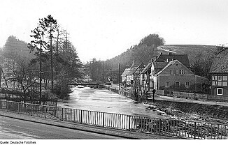
The Pließnitz in Kunnersdorf on the Eigen (1976) |
||
| Data | ||
| Water code | DE : 67432 | |
| location | Saxony, district of Görlitz | |
| River system | Or | |
| Drain over | Lusatian Neisse → Oder → Stettiner Haff | |
| origin | Confluence of Petersbach and Berthelsdorfer Wasser in Rennersdorf / OL 51 ° 1 ′ 16 ″ N , 14 ° 47 ′ 20 ″ E |
|
| Source height | 258.9 m above sea level NN | |
| muzzle | South of Görlitz near Hagenwerder coordinates: 51 ° 4 '12 " N , 14 ° 58' 4" E 51 ° 4 '12 " N , 14 ° 58' 4" E |
|
| Mouth height | 193 m above sea level NN | |
| Height difference | 65.9 m | |
| Bottom slope | 3.4 ‰ | |
| length | 19.3 km | |
| Catchment area | 180 km² | |
| Discharge at the level Tauchritz A Eo : 163 km² Location: 2.1 km above the mouth |
NNQ (07/23/2005) MNQ 1965/2005 MQ 1965/2005 Mq 1965/2005 MHQ 1965/2005 HHQ (07/20/1981) |
124 l / s 360 l / s 1.14 m³ / s 7 l / (s km²) 29.9 m³ / s 122 m³ / s |
| Medium-sized cities | Goerlitz | |
| Small towns | Bernstadt ad Eigen | |
The Pließnitz is an approximately 20 kilometer long left tributary of the Lausitzer Neisse in eastern Saxony . It arises southwest of Görlitz in Rennersdorf / OL through the confluence of the Petersbach and Berthelsdorfer Wasser , flows through the Eigenschen Kreis , and flows into the Neisse at Hagenwerder , over which the water flows into the Oder and further into the Baltic Sea .
The approximately 180 square kilometers large catchment area of the Pließnitz is almost half drained by its source rivers.
geography
The Petersbach, the longest source river of the Pließnitz at over ten kilometers, rises at around 362 m above sea level. NN am Kottmar . Flowing in an easterly direction, it absorbs several rivulets before changing its direction of flow to the southeast at Herrnhut . Near the Niederruppersdorf Castle , the Petersbach takes on the Ruppersdorfer Bach, also coming from the Kottmar . In the further course, now again eastward, the Petersbach takes up the Triebenbach and takes its northeast direction, only to take up the Erlichbach near Euldorf a little later . The now water-rich Petersbach meanders northwest on the Eichler and joins the Berthelsdorfer Wasser in Rennersdorf / OL to the north .
The Berthelsdorfer water rises in two springs in 375- 380 m above sea level. NN north of Strahwalde . It flows through Strahwalde and Berthelsdorf in an easterly direction before it changes its course to the southeast before Rennersdorf and finally joins the Petersbach.
The stream, now called Pließnitz, continues to flow in a north-easterly direction and enters the Eigenschen Kreis after Rennersdorf . The Pließnitz flows through Kunnersdorf and Bernstadt . In Altbernsdorf it takes the Kemnitzbach coming from the northwest and the Weißbach coming from the southwest.
In the further course it flowed through Schönau and Berzdorf before it took up the Gaulebach coming from Kiesdorf north of Hagenwerder and flowed into the Lausitz Neisse a little later . As a result of the lignite mining in the Berzdorf opencast mine , to which Berzdorf and part of Niederschönau fell victim, the Pließnitz had to be relocated. Today it is routed south of Schönau around the former opencast mine and now reaches the Neisse near Hagenwerder upstream of the original mouth.
Flood and flood protection
Wide floodplains and a low water level are characteristic of the course of the river. As a result of the short but steep rivers of the source brooks, the Pließnitz swells enormously in one to two hour downpours. The water level of the Petersbach can rise to over two meters within a short time, that of the Berthelsdorf water from 15 centimeters to a peak of 170 centimeters.

The floods of June 14, 1880 wreaked havoc. In sections, the water level of the Pließnitz reached a height of 6 meters within 15 minutes. A water level of 4.15 meters was reached at the Rittermühle in Rennersdorf / OL and a level of 2.79 meters at Sandmühlplatz in Bernstadt ad Eigen . The water masses destroyed and damaged numerous buildings and bridges. In Schönau auf dem Eigen , four houses, three barns and nine sheds were destroyed. 12 other buildings were so badly damaged that they had to be removed after the flood. 99 other buildings showed serious damage and 42 families with 137 people had become homeless. In Ruppersdorf / OL , four houses were torn away, in Rennersdorf the floods tore away 11 houses and brought another 23 buildings to collapse. In Bernstadt ad Eigen, 7 houses were washed away and 20 buildings collapsed. Due to the short warning time caused by the short period of time between the onset of precipitation and the occurrence of the flood peak, the flood claimed numerous lives. Contemporary sources give at least 31 deaths for the places along the Pließnitz (Ruppersdorf 1 dead, Rennersdorf 16 dead, Bernstadt 12 dead, Altbernsdorf auf dem Eigen 1 dead, Schönau 3 dead).
In order to contain the Pließnitz floods, which had left some devastation in the past centuries, the Rennersdorf flood retention basin was put into operation at Petersbach in 2010 . The flow rate of the Petersbach, which can rise from 0.48 m³ / s on average to more than 170 m³ / s, should be better regulated.
use
Since November 2002, water has been taken from the Pließnitz to flood Lake Berzdorf .
Evidence and further literature
literature
- Görlitz and its surroundings (= values of the German homeland . Volume 54). 1st edition. Verlag Hermann Böhlaus successor, Weimar 1994, ISBN 3-7400-0932-2 .
- Between Löbau and Herrnhut (= values of the German homeland . Volume 56). 1st edition. Verlag Hermann Böhlaus successor, Weimar 1996, ISBN 3-7400-0935-7 .
Footnotes
- ↑ Görlitz district geoportal. Office for District Development, District of Görlitz, accessed on April 22, 2012 .
- ↑ Hydrological Handbook. (PDF; 637 kB) Part 3 - Main aquatic values. Free State of Saxony - State Office for Environment and Geology, p. 72 , accessed on December 25, 2017 .
- ↑ a b G. Th. Reichelt: The flooding of the Lausitz on June 14, 1880 . Chemnitz 1880, p. 4 ( digital copy of the SLUB Dresden )
- ↑ Hildegard Kother: Severe weather in Großhennersdorf . In: Großhennersdorfer stories. Vol. 1, Großhennersdorf 2004, p. 4. ( online as PDF ( memento from July 23, 2015 in the Internet Archive ); 3.2 MB)
- ↑ How Pließnitz forced father and son to ride on the roof. In: Saxon newspaper. 17th August 2011.
- ↑ Manfred Winter: Water washes away houses and people. In: Saxon newspaper. October 5, 2002.
- ↑ Rennersdorf flood retention basin - new construction of a flood retention basin on Petersbach. (PDF; 1.6 MB) ( Memento from May 14, 2016 in the Internet Archive ), Landestalsperrenverwaltung Saxony , September 21, 2010.
- ↑ Around the Berzdorfer See. Archived from the original on July 8, 2012 ; Retrieved February 6, 2010 .

