
North Karelia
| coat of arms | map |
|---|---|

|
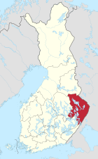  |
| Basic data | |
| Country: | Finland |
| Municipalities: | 13 |
| Administrative headquarters: | Joensuu |
| Surface: | 21,583.67 km² of which land: 17,762.59 |
| Residents: | 164,443 May 31, 2016 |
| Population density: | 7.6 inhabitants per km² |
| ISO 3166 : | FI-13 |
North Karelia ( Finnish. Pohjois-Karjala , Swedish. Norra Karelen ) is a landscape (maakunta) in Finland . From 1960 to 1997 it formed its own province (lääni) . North Karelia is part of the historical Karelia region divided between Finland and Russia . Until 1617 it belonged to the Russian Empire .
North Karelia is one of the most sparsely populated and structurally weakest regions in Finland. The largest city in the region is Joensuu .
North Karelia is the easternmost part of the continental area of the European Union . Only Cyprus is further east. There is a regional partnership with the Kusel district .
coat of arms
Description: The heraldic shield in red shows two silver right arms breaking out of the edge of the shield , swinging a silver sword with gold hilt on the right and a gold hilted scimitar on the left . A golden crown floats between the arms .
- see also the coat of arms of the Finnish region of North Karelia
Communities
There are 12 municipalities in North Karelia, five of which are cities (in bold). Population figures as of December 31, 2018.
- Ilomantsi (4973)
- Joensuu (76,551)
- Juuka (4709)
- Kitee (10,358)
- Kontiolahti (14,849)
- Lieksa (11,098)
- Liperi (12,145)
- Nurmes (7641 + 2143, with the municipality of Valtimo, which was incorporated on January 1, 2020)
- Outokumpu (6803)
- Polvijärvi (4307)
- Rääkkylä (2181)
- Tohmajärvi (4482)
swell
- ↑ Tilastokeskus.fi (Finnish Statistics Office), Finnish
- ↑ Statistical Office Finland: Table 11ra - Key figures on population by region, 1990-2018
Web links
Åland | Malice | Kuopio | Kymi | Lapland | Mikkeli | Central Finland | North Karelia | Oulu | Uusimaa | Turku-Pori | Vaasa