
Pontécoulant
| Pontécoulant | ||
|---|---|---|
|
||
| region | Normandy | |
| Department | Calvados | |
| Arrondissement | Vire | |
| Canton | Condé-sur-Noireau | |
| Community association | Intercom de la Vire au Noireau | |
| Coordinates | 48 ° 53 ′ N , 0 ° 35 ′ W | |
| height | 98–245 m | |
| surface | 2.38 km 2 | |
| Residents | 80 (January 1, 2017) | |
| Population density | 34 inhabitants / km 2 | |
| Post Code | 14110 | |
| INSEE code | 14512 | |

Pontécoulant is a French commune with a population of 80 (as at 1st January 2017) in the department of Calvados in the region of Normandy ; it belongs to the Arrondissement Vire and the canton of Condé-sur-Noireau .
geography
Pontécoulant is located about 38 kilometers south-southwest of Caen on the Druance river , which borders the municipality in the south. Pontécoulant is completely surrounded by the municipality of Condé-en-Normandie .
Population development
| year | 1962 | 1968 | 1975 | 1982 | 1990 | 1999 | 2006 | 2013 |
| Residents | 108 | 125 | 109 | 106 | 105 | 108 | 93 | 88 |
| Source: Cassini and INSEE | ||||||||
Attractions
- Saint-Michel church from the 18th century
- Pontécoulant castle from the 16th century with park, now a museum

Saint-Michel church
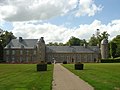
Pontécoulant Castle


Personalities
- Philippe Gustave le Doulcet, comte de Pontécoulant (1795–1874), astronomer
literature
- Le Patrimoine des Communes du Calvados. Volume 1, Flohic Editions, Paris 2001, ISBN 2-84234-111-2 , pp. 593-596.
Web links
Commons : Pontécoulant - collection of images, videos and audio files