Saint-Aubin-des-Bois (Calvados)
| Saint-Aubin-des-Bois | ||
|---|---|---|
|
|
||
| region | Normandy | |
| Department | Calvados | |
| Arrondissement | Vire | |
| Canton | Vire | |
| Community association | Intercom de la Vire au Noireau | |
| Coordinates | 48 ° 50 ′ N , 1 ° 8 ′ W | |
| height | 129-218 m | |
| surface | 8.26 km 2 | |
| Residents | 234 (January 1, 2017) | |
| Population density | 28 inhabitants / km 2 | |
| Post Code | 14380 | |
| INSEE code | 14559 | |
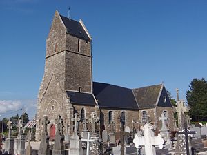
 Saint-Aubin church |
||
Saint-Aubin-des-Bois is a French commune with a population of 234 (as at 1st January 2017) in the department of Calvados in the region of Normandy . It belongs to the Arrondissement of Vire and the Canton of Vire . The inhabitants are known as Saintaulnais .
geography
Saint-Aubin-des-Bois is the westernmost municipality in the Calvados department. It is located around 73 km southwest of Caen , right on the border with the Manche department . The municipality is surrounded by Beslon in the north-west and north, Noues-de-Sienne in the entire east, Boisyvon in the south and Saint-Maur-des-Bois in the south-west and west.
Population development
| year | 1793 | 1836 | 1876 | 1926 | 1946 | 1968 | 1990 | 2016 |
| Residents | 636 | 660 | 588 | 446 | 408 | 351 | 230 | 237 |
| Source: Cassini, EHESS and INSEE | ||||||||
Attractions
- Saint-Aubin church from the 15th century; inside the church are two canopies and two grave stones from the 17th century as historique monument classified
- 19th century mansion
Web links
Commons : Saint-Aubin-des-Bois - Collection of images, videos and audio files
Individual evidence
- ↑ Saint-Aubin-des-Bois - Cassini
- ↑ Saint-Aubin-des-Bois - INSEE
- ↑ Baldachin (I) in the Base Palissy of the French Ministry of Culture (French)
- ↑ Gravestone (I) in the base Palissy of the French Ministry of Culture (French)
- ^ Gravestone (II) in the base Palissy of the French Ministry of Culture (French)
- ↑ Baldachin (II) in the Base Palissy of the French Ministry of Culture (French)
