
Longvillers
| Longvillers | ||
|---|---|---|
|
||
| region | Normandy | |
| Department | Calvados | |
| Arrondissement | Vire | |
| Canton | Aunay-sur-Odon | |
| Community association | Pré-Bocage intercom | |
| Coordinates | 49 ° 3 ′ N , 0 ° 38 ′ W | |
| height | 87-187 m | |
| surface | 6.65 km 2 | |
| Residents | 360 (January 1, 2017) | |
| Population density | 54 inhabitants / km 2 | |
| Post Code | 14310 | |
| INSEE code | 14379 | |
 Mairie of the parish |
||

Longvillers ( ) is a French municipality with 360 inhabitants (as of January 1 2017) in the department of Calvados in the region of Normandy . It belongs to the arrondissement of Vire and the canton of Aunay-sur-Odon .
geography
Longvillers is about 25 kilometers southwest of Caen . The municipality is surrounded by Épinay-sur-Odon in the north and north-east, Le Mesnil-au-Grain in the east and south-east, Aunay-sur-Odon in the south, Saint-Georges-d'Aunay in the south-west and west and Maisoncelles-Pelvey in northwest direction.
Population development
| year | 1793 | 1836 | 1876 | 1926 | 1946 | 1968 | 1990 | 2016 |
| Residents | 464 | 537 | 399 | 288 | 293 | 221 | 288 | 359 |
| Source: Cassini, EHESS and INSEE | ||||||||
Attractions
- Saint-Vigor church
- 15th century manor house
- Remains of the Longvillers monastery , a former Cistercian abbey from 1135
- Lavoir
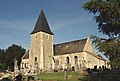
Saint-Vigor church
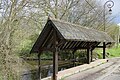
Lavoir


Web links
Commons : Longvillers - collection of images, videos and audio files
- General information about Longvillers on communes.com ( French )