
Malherbe-sur-Ajon
| Malherbe-sur-Ajon | ||
|---|---|---|
|
||
| region | Normandy | |
| Department | Calvados | |
| Arrondissement | Vire | |
| Canton | Aunay-sur-Odon | |
| Community association | Pré-Bocage intercom | |
| Coordinates | 49 ° 4 ′ N , 0 ° 34 ′ W | |
| height | 84-228 m | |
| surface | 11.77 km 2 | |
| Residents | 548 (January 1, 2017) | |
| Population density | 47 inhabitants / km 2 | |
| Post Code | 14260 | |
| INSEE code | 14037 | |

Malherbe-sur-Ajon is a French commune of 548 inhabitants (as of January 1, 2017) in the department of Calvados in the region of Normandy . It belongs to the arrondissement of Vire and the canton of Aunay-sur-Odon .
The municipality was created as part of a regional reform on January 1, 2016 through the merger of the former municipalities and now districts of Banneville-sur-Ajon and Saint-Agnan-le-Malherbe . Banneville-sur-Ajon acts as the "parent district" as the administrative center of Malherbe-sur-Ajon.
geography
Malherbe-sur-Ajon is surrounded by Landes-sur-Ajon in the north-west and north, Vacognes-Neuilly in the north-east, Maisoncelles-sur-Ajon in the east, Courvaudon in the south-east and south, Aunay-sur-Odon or Bauquay in the south-west and Le Mesnil -au-grain to the west.
structure
| District | INSEE code | Area (km²) | Population (2016) |
|---|---|---|---|
| Banneville-sur-Ajon (administrative headquarters) | 14037 | 5.63 | 430 |
| Saint-Agnan-le-Malherbe | 14553 | 6.14 | 119 |
Attractions
-
Banneville-sur-Ajon :
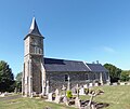
- neo-Gothic church of Saint-Melaine
- Saint Clair Chapel , Monument historique
-
Saint-Agnan-le-Malherbe :
- Saint-Agnan Church

Saint-Melaine church

Saint Clair Chapel
Saint-Agnan Church


Web links
Individual evidence
- ↑ Information text on the municipal merger on calvados.gouv.fr
- ↑ Population figures retrospectively from January 1, 2016
- ↑ Chapel Saint-Clair in the Base Mérimée of the French Ministry of Culture (French)