Prithvi Rajmarg
| Highway H4 in Nepal | |||||||||||||||||||||||||||||||||||||||||||||||||||||||||||||||||||||||||
| Prithvi Rajmarg पृथ्वी राजमार्ग |
|||||||||||||||||||||||||||||||||||||||||||||||||||||||||||||||||||||||||

|
|||||||||||||||||||||||||||||||||||||||||||||||||||||||||||||||||||||||||
| Basic data | |||||||||||||||||||||||||||||||||||||||||||||||||||||||||||||||||||||||||
| Operator: | Department of Roads | ||||||||||||||||||||||||||||||||||||||||||||||||||||||||||||||||||||||||
| Start of the street: |
Pokhara ( 28 ° 12 ′ N , 83 ° 59 ′ E ) |
||||||||||||||||||||||||||||||||||||||||||||||||||||||||||||||||||||||||
| End of street: |
Kathmandu ( 27 ° 42 ′ N , 85 ° 19 ′ E ) |
||||||||||||||||||||||||||||||||||||||||||||||||||||||||||||||||||||||||
| Overall length: | 174 km | ||||||||||||||||||||||||||||||||||||||||||||||||||||||||||||||||||||||||
|
Province: |
|||||||||||||||||||||||||||||||||||||||||||||||||||||||||||||||||||||||||
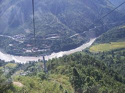
| Prithvi Rajmarg near Kurintar (Darechok) | |||||||||||||||||||||||||||||||||||||||||||||||||||||||||||||||||||||||||
|
Course of the road
|
|||||||||||||||||||||||||||||||||||||||||||||||||||||||||||||||||||||||||
The Prithvi Rajmarg ( Nepali पृथ्वी राजमार्ग ; English Prithvi Highway ) is a highway in Nepal that connects the capital Kathmandu with the city of Pokhara further west .
The 174 km long overland road runs from Pokhara in the valley of the Seti Gandaki via Lekhnath to Shuklagandaki . The road continues via Vyas to Dumre into the valley of the Marsyangdi . It follows the river via Ambukhaireni to its mouth. The Prithvi Rajmarg then runs upstream along the Trishuli . Finally it branches off to the east. At Naubise the Tribhuvan Rajmarg meets the Prithvi Rajmarg coming from the south. The Prithvi Rajmarg reaches the greater Kathmandu area and ends in the capital. The trunk road was completed in 1974.
Web links
Commons : Prithvi Rajmarg - Collection of images, videos and audio files
