Benguela Province
| Benguela | |
|---|---|
| Basic data | |
| Country | Angola |
| Capital | Benguela |
| surface | 39,826.8 km² |
| Residents | 2,231,385 (2014) |
| density | 56 inhabitants per km² |
| ISO 3166-2 | AO-BGU |
| Website | www.benguela.gov.ao ( Portuguese ) |
| politics | |
| Governador | Isaac Francisco Maria dos Anjos |
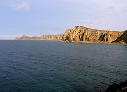
| The Blue Bay in the Benguela Province | |
Coordinates: 12 ° 33 ' S , 13 ° 31' E
Benguela is a province of the African state of Angola .
history
The Portuguese crown created the Kingdom of Benguela in 1615 in order to create the prerequisites for developing the desired land connection to Mozambique . Benguela was, along with the Kingdom of Congo and the Kingdom of Ngola, one of the three kingdoms in Angola that were contractually linked with Portugal. The trade base established here did not meet the expectations of the Portuguese in terms of mineral resources and soil quality, so that only a village for slave trade emerged here, under the name Mbaka. Until the 19th century, Mbaka was the end point for slave caravans from the interior of Africa.
With the age of the imperialist efforts of European states to acquire colonies in Africa, Portugal increased its presence in the region at the end of the 19th century in order to protect it from the desires of the German Empire and other states. Even before the Berlin Congo Conference , at which the European powers divided up the African colonial territories in 1884/85, Portugal had strengthened its colonial administration in 1869 and divided Angola into the three districts of Luanda , Benguela and Moçâmedes . This was followed by the elevation of the towns of Bocoio , Balombo and Ganda to small towns ( Vilas ), as seats of now independent districts, and in 1913 Lobito was raised to a city ( Cidade ). In the course of its development towards the end of the 19th century, and further strengthened around 1940, the population of the region increased and changed with the influx of other peoples. Among them are the Angola Germans .
The Benguela Railway , built from 1899 , the growing importance of the port of Lobito, and the emerging industrial operations, especially for processing sisal fiber , ensured sustained development in the Benguela district, which only subsided when the sisal market collapsed in the 1960s. Since then, after turning to the rich fish stocks off the coast, fishing has provided the most important economic impetus.
From the end of the 1960s, the population structure changed again as a result of the regional economic upheaval, but in particular due to the massive emigration of European settlers after Angola's independence in 1975 and the influx of numerous internally displaced persons during the Angolan civil war (1975-2002).
administration
The province of Benguela has an area of 39,827 km² and about 2.2 million inhabitants (2014 census), about 68.6% of whom live in the coastal districts of Lobito, Benguela and Baía Farta. The capital is the city of Benguela , the second largest city in the province after Lobito.
The province is divided into ten districts ( Municipios ), which are further structured in 39 municipalities (Comunas).
The counties of the Benguela Province:
Web links
- Official website of the provincial government
- Profile of the province of Benguela on the official website for the 2014 census
- 1988 U.S. government statistics
- Benguela Province presented by the Angolan Embassy in London
Individual evidence
- ^ Provincial history page on the provincial government website, accessed April 19, 2014
- ↑ Profile of Benguela Province on the official website of the Provincial Government, accessed March 6, 2013
- ^ Angola: Administrative division (provinces and municipalities) - population figures, charts and map. Retrieved March 1, 2018 .


