Rübke (Neu Wulmstorf)
|
Rübke
Unified municipality Neu Wulmstorf
|
|
|---|---|
| Coordinates: 53 ° 29 ′ 30 ″ N , 9 ° 46 ′ 35 ″ E | |
| Height : | -1–7 m |
| Residents : | 583 (December 1, 2016) |
| Incorporation : | July 1, 1972 |
| Postal code : | 21629 |
| Area code : | 040 |
|
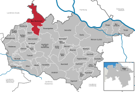
Location of Rübke in Neu Wulmstorf
|
|
|
Apple harvest in Rübke
|
|
(Low German Rübk) is part of the unified community ofNeu Wulmstorfinthe Harburg districtin northeasternLower Saxonyin theHamburg metropolitan regionand has around 600 inhabitants.
geography
location
Rübke is located on the southern border of the third mile of the Old Country and essentially consists of the two streets Nincoper Deich and Buxtehude Straße.
Natural allocation
Rübke is located in the extreme southeast of the natural area Das Alte Land (No. 670.02), which belongs to the main unit Harburger Elbmarschen (670) and the main unit group Lower Elbe Lowlands (Elbmarsch) (67). Directly to the south are the Harburg Mountains in the Black Mountains natural area (640.00) in the sub-unit Wilseder terminal moraines (640.0), which belong to the main unit Hohe Heide (640) and the main unit group Lüneburg Heath (64).
Neighboring communities
In the south, Rübke in the community of Neu Wulmstorf borders on the district of Neu Wulmstorf, in the west on Buxtehude , in the north and east on Hamburg .
history
As part of the three miles of self-governing Alten Land, Rübke belonged to the Prussian district of Jork until August 1, 1932 , before it became part of the Harburg district when it was dissolved. During the storm surge in 1962 , Rübke was affected by floods as a result of large dike breaches in the Süderelbe area between Neuenfelde and Harburg .
Incorporations
Rübke went on in the course of the establishment of the unified community Neu Wulmstorf on July 1, 1972 in Neu Wulmstorf.
Population development
During the French period , Rüpke had 387 inhabitants and belonged to the Département des Bouches de l'Elbe in the Mairie Estebrugge and the east side of the moor .
On December 1, 1910, Rübke had 353 inhabitants.
| year | 1812 | 1910 | 1925 | 1933 | 1939 | 2015 | 2016 |
|---|---|---|---|---|---|---|---|
| population | 387 | 353 | 397 | 399 | 350 | 550 | 583 |
traffic
Rübke is located north of the third construction phase of the federal motorway 26 , the railway line Hamburg-Harburg - Cuxhaven ( Niederelbebahn ) with a stop of the Hamburg S-Bahn (S3 Stade-Pinneberg) and the federal highway 73 .
As part of the planning for the A26, there were considerable conflicts in connection with the route on the southern outskirts. Due to the directly adjacent nature reserve Moorgürtel and “ Moore bei Buxtehude ”, a very local route was chosen, which meets with resistance from the residents. The completion of the construction phase with its own junction is planned for 2020. After that, there will be a particular traffic load, as the connection to the federal motorway 7 through the Hamburg state is not yet foreseeable and the A26 will end here for at least a few years. An already completed first section of the federal highway 3n then connects the A26 with the B73 west of Neu Wulmstorf.
nature
Rübke is located in the middle of some special local recreation areas and nature reserves :
- Old country
- Harburg Mountains
- NSG moor belt
- NSG Moore near Buxtehude (an EU bird sanctuary )
- NSG Fischbeker Heide
- LSG Buxtehuder Geestrand
Web links
Individual evidence
- ↑ a b “Things worth knowing about the community of Neu Wulmstorf”, status of the population: December 2016, leaflet of the community of Neu Wulmstorf, January 2017
- ^ Prussian State Ministry, § 66, Ordinance on the reorganization of districts, from August 1, 1932 Preußische Gesetzessammlung, Berlin 1932; No. 43 , R. von Deckers Verlag, G. Schenk, 1932, pages 255-273
- ↑ NI GVBl., June 23, 1972, Law on the reorganization of the municipalities in the Harburg area, Lower Saxony Law and Ordinance Gazette 1972, (No. 30, pp. 320–322)
- ↑ The story of Neu Wulmstorf
- ↑ a b A. FL Lasius: The French Imperial State under the government of Emperor Napoleon the Great in 1812. Kißling, Osnabrück 1813, p. 57 ( online ).
- ^ A b Register of municipalities in Germany 1900, Kingdom of Prussia, Province of Hanover, District of Stade, District of Jork
- ^ A b c Michael Rademacher: German administrative history. (No longer available online.) Archived from the original on September 24, 2015 ; accessed on March 9, 2015 . Info: The archive link was inserted automatically and has not yet been checked. Please check the original and archive link according to the instructions and then remove this notice.
- ^ A 26: Start of construction between Buxtehude and Neu Wulmstorf. September 5, 2013, archived from the original on October 29, 2013 ; Retrieved September 15, 2013 .
- ↑ A26: Start of construction for the third section. (No longer available online.) August 19, 2013, formerly in the original ; Retrieved September 15, 2013 . ( Page no longer available , search in web archives ) Info: The link was automatically marked as defective. Please check the link according to the instructions and then remove this notice.


