San (river)
|
San Сян, Saan |
||
|
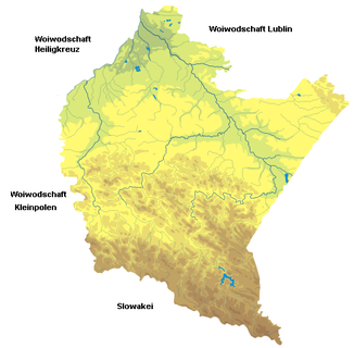
The San River System within the Subcarpathian Mountains (Woj.) |
||
| Data | ||
| location | Ukraine , Poland | |
| River system | Vistula | |
| Drain over | Vistula → Baltic Sea | |
| source | At Bieszczady in Poland / Ukraine 49 ° 0 ′ 10 ″ N , 22 ° 52 ′ 30 ″ E |
|
| Source height | 950 m npm | |
| muzzle | near Szczytniki in the Vistula ( Wisła ) Coordinates: 50 ° 44 ′ 12 " N , 21 ° 50 ′ 43" E 50 ° 44 ′ 12 " N , 21 ° 50 ′ 43" E |
|
| Mouth height | 0 m npm | |
| Height difference | 950 m | |
| Bottom slope | 2.2 ‰ | |
| length | 433 km | |
| Catchment area | 16,861 km² | |
| Drain |
MQ |
210 m³ / s |
| Left tributaries | Wisłok , Osława | |
| Right tributaries | Wiar , Tanew , Lubaczówka | |
| Big cities | Lesko , Sanok , Przemyśl , Stalowa Wola | |
| Medium-sized cities | Jaroslaw | |
| Small towns | Dynów | |
|
Saantal, below the Sobień mountain near Sanok, Poland |
||
|
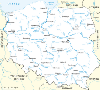
Location of the San in the Polish river system |
||
The San ( Ukrainian Сян ; German Saan ) is a right tributary of the Vistula in southeastern Poland , on the border with Ukraine .
The river has its source on the northern slope of the Carpathian Forest at the Uschok Pass on the Carpathian watershed , not far from the source of the Ush . The source is located in the southeast of the Bieszczady National Park on Ukrainian territory. Piniaszkowy Peak and Sjanky are nearby. The San initially flows to the northwest, from Sanok to the north, from Dynów to the east, from Przemyśl again to the northwest, leaves the mountainous region at Jarosław and flows into the Vistula below Sandomierz .
A little below its source, the San forms the border between Poland and Ukraine for around 50 km , after which it flows through Polish territory.
The San has a length of 433 km, making it the sixth longest Polish river. It is navigable from Jarosław . The catchment area is 16,861 km², of which 14,390 km² in Poland, the rest in Ukraine.
Together with Pisa , Narew and Vistula, the San defined the border between the German and Soviet spheres of interest, as laid down in the secret additional protocol to the German-Soviet non-aggression pact of August 23, 1939. After a section of this border was moved from the Vistula to the Bug in the subsequent diplomatic agreements , Poland was divided for the fourth time in September 1939 .
The name
On old maps one can find the spellings 1097 san , reku Sanъ , k Sanovi , nad Sanomъ (1152), Sanu (1287), San 1339, Szan 1406, Sanok 1438, Saan 1439, Sayn 1445, San 1467, Szan 1517, Schan 1526 The name can be derived from the Proto-Indo-European word san ("quickly" or "fast river"), in Celtic the word "san" means "river".
Important tributaries
|
in the upper reaches |
in the lower reaches
|
Cities on the San
literature
- Janusz Rieger : names of waters in the river basin of the San catchment area . Steiner, 2004, ISBN 3-515-08522-X
- Janusz Rieger: names of waters in the Wislok river basin . Stuttgart 1988.
- Akta Grodzkie i Ziemskie . Lwów 1868
- Adam Carnival: Osadnictwo Ziemi Sanockiej . 1946
- Adam Fastnacht: Slownik Historyczno-Geograficzny Ziemi Sanockiej w Sredniowieczu . Krakow 2002, ISBN 83-88385-14-3
- Ernst Schwarz : From the " Forest Germans " in Galicia . In: Silesia . Volume III, pp. 147-156.
- Wojciech Blajer : Comments on the state of research on the Enklawen of the medieval German settlement between Wisłoka and San . In: Jan Gancarski (Red.): Późne średniowiecze w Karpatach polskich . Krosno 2007, ISBN 978-83-60545-57-7
Web links
Individual evidence
- ↑ Josef von Reilly . The Kingdom of Galicia and Lodomeria middle circles. Nro. 36. Vienna. 1791 .; “The Saan, which rises in the Sanok district, on the Saana mountain, from which the Sanok guttes the Oslawa river , from there goes to the towns of Przemisl, Jaroslaw, etc., and falls above Radomisl into the Wiechsel. This river is also navigable ”. [in:] Johann Andreas Demian: Representation of the Austrian monarchy according to the latest statistical relationships . 1804. p. 12.
- ↑ "similar to the name above, from: Sa (a common river name) and boki ( bok the side, the edge, the bank) ab, similar to Rhineland and analogous to the Bialoboki, Wisloboki, Naliboki, Cetyrboki, composed ( Sa residents)" . [in:] Roman St. Kaulfuss: The Slavs in the oldest times up to Samo (623) . 1842, p. 45; "As Sa-boki instead of San-boki (those who live on the San River)" [in:] Yearbooks for Scientific Criticism . 1843; “South of the Avareni (in Galicia ) set Ptolom. the Anartophracti (south of the Ombrones). The Burgiones are followed by the Arsiaetae, then the Saboki (on the San), the Piengitae [...] “[in:] Zeitschrift für Ethnologie . Berlin Society for Anthropology, Ethnology and Prehistory. German Society for Anthropology, Ethnology and Prehistory, German Society for Ethnology. Volume 3. 1871, p. 481.
- ^ "[...] San (Latin graphics as in Sandomierz , Santok , etc.). Cf. altind. sindhu- "river", the Irish GN Shannon and the Maiz tributary Sinn “[in:] Irena Kwilecka : Etnolingwistyczne i kulturowe związki Słowian z Germanami . Instytut Słowianoznawstwa PAN . 1987. ISBN 83-04-02472-1 , p. 64.


